 |
|
Cheraw Muni/lynch Bellinger Field Airport |
Cheraw Municipal Airport
Lynch Bellinger Field |
| IATA: HCW – ICAO: KCQW – FAA LID: CQW |
| Summary |
| Airport type |
Public |
| Owner |
Town of Cheraw |
| Serves |
Cheraw, South Carolina |
| Elevation AMSL |
239 ft / 73 m |
| Coordinates |
34°42′46″N 079°57′25″W / 34.71278°N 79.95694°W / 34.71278; -79.95694 |
| Runways |
| Direction |
Length |
Surface |
| ft |
m |
| 8/26 |
5,000 |
1,524 |
Asphalt |
| Statistics (2008) |
| Aircraft operations |
17,900 |
| Based aircraft |
18 |
| Source: Federal Aviation Administration |
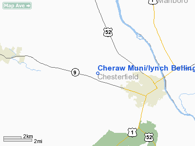
Cheraw Municipal Airport (IATA: HCW, ICAO: KCQW, FAA LID: CQW), also known as Lynch Bellinger Field, is a public use airport in Chesterfield County, South Carolina, United States. It is owned by the Town of Cheraw and located three nautical miles (6 km) northwest of its central business district.
Although most U.S. airports use the same three-letter location identifier for the FAA and IATA, this airport is assigned CQW by the FAA and HCW by the IATA.
Facilities and aircraft
The airport covers an area of 235 acres (95 ha) at an elevation of 239 feet (73 m) above mean sea level. It has one runway designated 8/26 with an asphalt surface measuring 5,000 by 75 feet (1,524 x 23 m).
For the 12-month period ending May 1, 2008, the airport had 17,900 aircraft operations, an average of 49 per day: 99% general aviation and 1% military. At that time there were 18 aircraft based at this airport: 16 single-engine, 1 jet and 1 helicopter.
The above content comes from Wikipedia and is published under free licenses – click here to read more.
Location & QuickFacts
| FAA Information Effective: | 2008-09-25 |
| Airport Identifier: | CQW |
| Airport Status: | Operational |
| Longitude/Latitude: | 079-57-25.2150W/34-42-46.3500N
-79.957004/34.712875 (Estimated) |
| Elevation: | 239 ft / 72.85 m (Surveyed) |
| Land: | 235 acres |
| From nearest city: | 3 nautical miles NW of Cheraw, SC |
| Location: | Chesterfield County, SC |
| Magnetic Variation: | 08W (2005) |
Owner & Manager
| Ownership: | Publicly owned |
| Owner: | Town Of Cheraw |
| Address: | P O Box 111
Cheraw, SC 29520 |
| Phone number: | 843-537-7283 |
| Manager: | Wendell Hall |
| Address: | Rt 3, Box 250
Cheraw, SC 29520 |
| Phone number: | 843-537-6423 |
Airport Operations and Facilities
| Airport Use: | Open to public |
| Wind indicator: | Yes |
| Segmented Circle: | Yes |
| Control Tower: | No |
| Lighting Schedule: | DUSK-DAWN
ACTVT MIRL RY 07/25 - CTAF. MIRL RY 07/25 OPERS LOW INTST CONT. |
| Beacon Color: | Clear-Green (lighted land airport) |
| Landing fee charge: | No |
| Sectional chart: | Charlotte |
| Region: | ASO - Southern |
| Boundary ARTCC: | ZJX - Jacksonville |
| Tie-in FSS: | AND - Anderson |
| FSS on Airport: | No |
| FSS Toll Free: | 1-800-WX-BRIEF |
| NOTAMs Facility: | AND (NOTAM-d service avaliable) |
| Federal Agreements: | NGY |
Airport Communications
| CTAF: | 122.800 |
| Unicom: | 122.800 |
Airport Services
| Fuel available: | 100LLA |
| Airframe Repair: | MAJOR |
| Power Plant Repair: | MAJOR |
| Bottled Oxygen: | NONE |
| Bulk Oxygen: | NONE |
Runway Information
Runway 08/26
| Dimension: | 5000 x 75 ft / 1524.0 x 22.9 m |
| Surface: | ASPH, Good Condition |
| Surface Treatment: | Porous Friction Course |
| Weight Limit: | Single wheel: 30000 lbs.
Dual wheel: 48000 lbs. |
| Edge Lights: | Medium |
| |
Runway 08 |
Runway 26 |
| Longitude: | 079-57-53.3700W | 079-56-57.0600W |
| Latitude: | 34-42-37.9200N | 34-42-54.7800N |
| Elevation: | 239.00 ft | 188.00 ft |
| Alignment: | 70 | 127 |
| Traffic Pattern: | Left | Left |
| Markings: | Non-precision instrument, Good Condition | Non-precision instrument, Good Condition |
| Crossing Height: | 33.00 ft | 26.00 ft |
| VASI: | 2-light PAPI on left side | 2-light PAPI on left side |
| Visual Glide Angle: | 3.45° | 3.00° |
| Runway End Identifier: | Yes | Yes |
| Obstruction: | 43 ft pole, 644.0 ft from runway, 295 ft left of centerline, 10:1 slope to clear | 48 ft pole, 1193.0 ft from runway, 303 ft right of centerline, 20:1 slope to clear |
|
Radio Navigation Aids
| ID |
Type |
Name |
Ch |
Freq |
Var |
Dist |
| CQW | NDB | Cheraw | | 409.00 | 05W | 4.8 nm |
| BES | NDB | Bennettsville | | 230.00 | 07W | 12.4 nm |
| RCZ | NDB | Roscoe | | 375.00 | 07W | 15.5 nm |
| UDG | NDB | Darlington | | 245.00 | 06W | 16.6 nm |
| PYG | NDB | Pageland | | 270.00 | 06W | 18.9 nm |
| AFP | NDB | Anson County | | 283.00 | 07W | 19.7 nm |
| HVS | NDB | Hartsville | | 341.00 | 07W | 20.1 nm |
| ME | NDB | Maxtn | | 257.00 | 08W | 25.4 nm |
| HFF | NDB | Mackall | | 278.00 | 06W | 30.0 nm |
| DLC | NDB | Dillon | | 274.00 | 05W | 33.1 nm |
| CDN | NDB | Camden | | 263.00 | 05W | 39.5 nm |
| TWL | NDB | Wesley | | 204.00 | 06W | 39.6 nm |
| JB | NDB | Jigel | | 384.00 | 08W | 41.7 nm |
| MAO | NDB | Marion | | 388.00 | 06W | 44.3 nm |
| LKR | NDB | Lancaster | | 400.00 | 07W | 44.5 nm |
| RSY | NDB | Robeson | | 359.00 | 08W | 44.8 nm |
| VU | NDB | Aller | | 346.00 | 06W | 47.0 nm |
| SMS | NDB | Sumter | | 252.00 | 04W | 47.8 nm |
| LBT | VOR | Lumberton | | 110.00 | 08W | 45.0 nm |
| CTF | VOR/DME | Chesterfield | 019X | 108.20 | 03W | 16.2 nm |
| FLO | VORTAC | Florence | 099X | 115.20 | 03W | 32.5 nm |
| SDZ | VORTAC | Sandhills | 055X | 111.80 | 03W | 35.3 nm |
Images and information placed above are from
http://www.airport-data.com/airport/CQW/
We thank them for the data!
| General Info
|
| Country |
United States
|
| State |
SOUTH CAROLINA
|
| FAA ID |
CQW
|
| Time |
UTC-5(-4DT)
|
| Latitude |
34.712875
34° 42' 46.35" N
|
| Longitude |
-79.957006
079° 57' 25.22" W
|
| Elevation |
239 feet
73 meters
|
| Type |
Civil
|
| Magnetic Variation |
007° W (01/06)
|
| Beacon |
Yes
|
| Operating Agency |
U.S.CIVIL AIRPORT WHEREIN PERMIT COVERS USE BY TRANSIT MILITARY AIRCRAFT
|
| Operating Hours |
SEE REMARKS FOR OPERATING HOURS OR COMMUNICATIONS FOR POSSIBLE HOURS
|
| Daylight Saving Time |
Second Sunday in March at 0200 to first Sunday in November at 0200 local time (Exception Arizona and that portion of Indiana in the Eastern Time Zone)
|
We don't guarantee the information is fresh and accurate. The data may
be wrong or outdated.
For more up-to-date information please refer to other sources.
|
|


