 |
|
Charleston Executive Airport |
| Charleston Executive Airport |
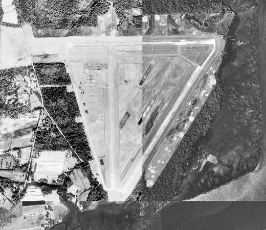 |
| USGS aerial image as of 12 February 1989 |
| IATA: none – ICAO: KJZI – FAA LID: JZI |
| Summary |
| Airport type |
Public |
| Owner |
Charleston County Aviation Authority |
| Serves |
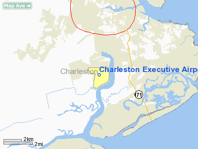
Charleston, South Carolina |
| Elevation AMSL |
17 ft / 5 m |
| Coordinates |
32°42′03″N 080°00′10″W / 32.70083°N 80.00278°W / 32.70083; -80.00278 |
| Runways |
| Direction |
Length |
Surface |
| ft |
m |
| 9/27 |
5,000 |
1,524 |
Concrete |
| 4/22 |
4,313 |
1,315 |
Concrete |
| Statistics (2008) |
| Aircraft operations |
55,000 |
| Based aircraft |
58 |
| Source: Federal Aviation Administration |
Charleston Executive Airport (ICAO: KJZI, FAA LID: JZI) is a public use airport located in Charleston in Charleston County, South Carolina, United States. It is approximately six nautical miles (11 km) southwest of the central business district of the city. It is owned by the Charleston County Aviation Authority. The airport serves the general aviation community, with no scheduled commercial airline service.
Although most U.S. airports use the same three-letter location identifier for the FAA and IATA, this airport is assigned JZI by the FAA but has no designation from the IATA. History
The airport opened in April 1943 named Johns Island Army Airfield. Initially it was an auxiliary to Columbia Army Air Base as an unmanned emergency landing airfield. On 31 March 1944, jurisdiction was transferred to Charleston Army Airfield when Charleston was reassigned to Air Transport Command. It served as an emergency landing base with no permanent structures being used for transatlantic flights. On 25 August 1945 the airfield was turned over to local authorities which converted it into a civil airport. The occasional military aircraft still uses the airport.
Facilities and aircraft
Charleston Executive Airport covers an area of 1,373 acres (556 ha) at an elevation of 17 feet (5 m) above mean sea level. It has two concrete paved runways: 9/27 is 5,000 by 150 feet (1,524 x 46 m) and 4/22 is 4,313 by 150 feet (1,315 x 46 m).
For the 12-month period ending October 23, 2008, the airport had 55,000 aircraft operations, an average of 150 per day: 91% general aviation and 5% military and 4% air taxi. At that time there were 58 aircraft based at this airport: 79% single-engine, 16% multi-engine, 2% jet and 3% helicopter.
The above content comes from Wikipedia and is published under free licenses – click here to read more.
Location & QuickFacts
| FAA Information Effective: | 2008-09-25 |
| Airport Identifier: | JZI |
| Airport Status: | Operational |
| Longitude/Latitude: | 080-00-10.5000W/32-42-03.1000N
-80.002917/32.700861 (Estimated) |
| Elevation: | 17 ft / 5.18 m (Surveyed) |
| Land: | 1373 acres |
| From nearest city: | 6 nautical miles SW of Charleston, SC |
| Location: | Charleston County, SC |
| Magnetic Variation: | 05W (1985) |
Owner & Manager
| Ownership: | Publicly owned |
| Owner: | Charleston Co Avn Authority |
| Address: | 5500 Intl Blvd, Rm 101
Charleston, SC 29418-6911 |
| Phone number: | 843-767-7010 |
| Manager: | Sue Stevens |
| Address: | 5500 International Blvd
Charleston, SC 29418 |
| Phone number: | 843-767-7010 |
Airport Operations and Facilities
| Airport Use: | Open to public |
| Wind indicator: | Yes
SUPPLEMENTARY UNLGTD WINDCONES RYS 04 & 27. |
| Segmented Circle: | Yes |
| Control Tower: | No |
| Lighting Schedule: | DUSK-DAWN
ACTVT MIRL RY 04/22 & HIRL RY 09/27 - CTAF. |
| Beacon Color: | Clear-Green (lighted land airport) |
| Landing fee charge: | No |
| Sectional chart: | Charlotte |
| Region: | ASO - Southern |
| Boundary ARTCC: | ZJX - Jacksonville |
| Tie-in FSS: | AND - Anderson |
| FSS on Airport: | No |
| FSS Toll Free: | 1-800-WX-BRIEF |
| NOTAMs Facility: | AND (NOTAM-d service avaliable) |
| Federal Agreements: | NGPRY |
Airport Communications
| CTAF: | 122.800 |
| Unicom: | 122.800 |
Airport Services
| Fuel available: | 100LLA |
| Airframe Repair: | MINOR |
| Power Plant Repair: | MINOR |
| Bulk Oxygen: | NONE |
Runway Information
Runway 04/22
| Dimension: | 4313 x 150 ft / 1314.6 x 45.7 m |
| Surface: | CONC, Good Condition
RY 09/27 PAVEMENT SHOWING EXTENSIVE WEAR AND DETERIORATION. |
| Weight Limit: | Single wheel: 45000 lbs.
Dual wheel: 56000 lbs. |
| Edge Lights: | Medium |
| |
Runway 04 |
Runway 22 |
| Longitude: | 080-00-20.9890W | 079-59-54.0921W |
| Latitude: | 32-41-28.0251N | 32-42-04.1380N |
| Elevation: | 10.00 ft | 11.00 ft |
| Alignment: | 32 | 127 |
| Traffic Pattern: | Left | Left |
| Markings: | Basic, Good Condition | Basic, Good Condition |
| Obstruction: | 75 ft tree, 2134.0 ft from runway, 259 ft right of centerline, 25:1 slope to clear | 67 ft tree, 2670.0 ft from runway, 391 ft right of centerline, 36:1 slope to clear |
|
Runway 09/27
| Dimension: | 5000 x 150 ft / 1524.0 x 45.7 m |
| Surface: | CONC, Fair Condition
RY 09/27 PAVEMENT SHOWING EXTENSIVE WEAR AND DETERIORATION. |
| Weight Limit: | Single wheel: 45000 lbs.
Dual wheel: 56000 lbs. |
| Edge Lights: | High |
| |
Runway 09 |
Runway 27 |
| Longitude: | 080-00-42.3324W | 079-59-43.8236W |
| Latitude: | 32-42-17.5234N | 32-42-18.1755N |
| Elevation: | 17.00 ft | 10.00 ft |
| Alignment: | 89 | 127 |
| ILS Type: | ILS/DME
| |
| Traffic Pattern: | Left | Left |
| Markings: | Non-precision instrument, Good Condition
ALL MARKINGS ON RY 09/27 ARE FADING DUE TO EXCESSIVE RUBBER BUILD UP AND WEATHER. | Non-precision instrument, Good Condition |
| Crossing Height: | 49.00 ft | 43.00 ft |
| VASI: | 4-light PAPI on left side | 4-light PAPI on left side |
| Visual Glide Angle: | 3.00° | 3.00° |
| Obstruction: | 74 ft tree, 2782.0 ft from runway, 522 ft right of centerline, 35:1 slope to clear | 81 ft , 4188.0 ft from runway, 399 ft left of centerline, 49:1 slope to clear |
|
Radio Navigation Aids
| ID |
Type |
Name |
Ch |
Freq |
Var |
Dist |
| JZI | NDB | Johns Island | | 283.00 | 05W | 0.2 nm |
| CH | NDB | Ashly | | 329.00 | 05W | 17.2 nm |
| DYB | NDB | Dorchester County | | 365.00 | 05W | 25.7 nm |
| MKS | NDB | Moncks Corner | | 354.00 | 05W | 29.5 nm |
| RBW | NDB | Walterboro | | 221.00 | 05W | 34.9 nm |
| NBC | TACAN | Beaufort | 042X | | 05W | 38.6 nm |
| CHS | VORTAC | Charleston | 082X | 113.50 | 05W | 11.8 nm |
| CHS | VOT | Charleston | | 111.00 | | 12.5 nm |
Remarks
- DEER & BIRDS ON & INVOF ARPT.
- UNEVEN/BROKEN PAVEMENT ON RY 09/27
- ARPT CLSD TO SINGLE-WHEEL ACFT WITH PUBLISHED MAX TKOF WT OVR 45,000 LBS AND DUAL WHEEL ACFT WITH PUBLISHED MAX TKOF WT OVR 56,000 LBS.
- ARPT EXISTED PRIOR TO 1958
Images and information placed above are from
http://www.airport-data.com/airport/JZI/
We thank them for the data!
| General Info
|
| Country |
United States
|
| State |
SOUTH CAROLINA
|
| FAA ID |
JZI
|
| Latitude |
32-42-03.100N
|
| Longitude |
080-00-10.500W
|
| Elevation |
17 feet
|
| Near City |
CHARLESTON
|
We don't guarantee the information is fresh and accurate. The data may
be wrong or outdated.
For more up-to-date information please refer to other sources.
|
|


