 |
|
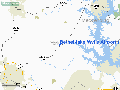
Bethel-lake Wylie Airport |
Location & QuickFacts
| FAA Information Effective: | 2008-09-25 |
| Airport Identifier: | SC08 |
| Airport Status: | Operational |
| Longitude/Latitude: | 081-08-14.2700W/35-03-00.5040N
-81.137297/35.050140 (Estimated) |
| Elevation: | 670 ft / 204.22 m (Estimated) |
| Land: | 150 acres |
| From nearest city: | 6 nautical miles NE of York, SC |
| Location: | York County, SC |
| Magnetic Variation: | 05W (1985) |
Owner & Manager
| Ownership: | Privately owned |
| Owner: | William F. Childers |
| Address: | 7552 Charlotte Hwy
York, SC 29745 |
| Phone number: | 803-684-6345 |
| Manager: | William F. Childers |
| Address: | 7552 Charlotte Hwy
York, SC 29745 |
| Phone number: | 803-684-6345 |
Airport Operations and Facilities
| Airport Use: | Private |
| Segmented Circle: | No |
| Control Tower: | No |
| Sectional chart: | Atlanta |
| Region: | ASO - Southern |
| Boundary ARTCC: | ZTL - Atlanta |
| Tie-in FSS: | AND - Anderson |
| FSS Toll Free: | 1-800-WX-BRIEF |
Runway Information
Runway 04/22
| Dimension: | 1500 x 70 ft / 457.2 x 21.3 m |
| Surface: | TURF, Poor Condition |
| |
Runway 04 |
Runway 22 |
| Traffic Pattern: | Left | Left |
|
Radio Navigation Aids
| ID |
Type |
Name |
Ch |
Freq |
Var |
Dist |
| GHJ | NDB | Stonia | | 260.00 | 06W | 8.5 nm |
| UZ | NDB | Rally | | 227.00 | 05W | 10.0 nm |
| DCM | NDB | Chester | | 220.00 | 06W | 16.1 nm |
| TWL | NDB | Wesley | | 204.00 | 06W | 22.1 nm |
| LKR | NDB | Lancaster | | 400.00 | 07W | 24.0 nm |
| SLP | NDB | First River | | 417.00 | 06W | 25.7 nm |
| IZN | NDB | Lincolnton | | 432.00 | 06W | 29.4 nm |
| UOT | NDB | Union County | | 326.00 | 04W | 33.2 nm |
| FRT | NDB | Fairmont | | 248.00 | 05W | 42.7 nm |
| PYG | NDB | Pageland | | 270.00 | 06W | 43.5 nm |
| VW | NDB | Temky | | 280.00 | 05W | 43.7 nm |
| RFE | NDB | Rutherford | | 344.00 | 05W | 43.9 nm |
| FDW | NDB | Winnsboro | | 414.00 | 05W | 44.2 nm |
| HK | NDB | Tawba | | 332.00 | 06W | 45.0 nm |
| FIQ | NDB | Fiddlers | | 391.00 | 07W | 47.5 nm |
| CLT | VOR/DME | Charlotte | 097X | 115.00 | 05W | 12.4 nm |
| CTF | VOR/DME | Chesterfield | 019X | 108.20 | 03W | 48.9 nm |
| BZM | VOR/DME | Barretts Mountain | 045X | 110.80 | 06W | 49.5 nm |
| FML | VORTAC | Fort Mill | 071X | 112.40 | 02W | 9.7 nm |
| SPA | VORTAC | Spartanburg | 104X | 115.70 | 02W | 38.9 nm |
| CLT | VOT | Charlotte | | 112.00 | | 13.9 nm |
| HKY | VOT | Hickory Regional | | 110.00 | | 43.3 nm |
Remarks
Images and information placed above are from
http://www.airport-data.com/airport/SC08/
We thank them for the data!
| General Info
|
| Country |
United States
|
| State |
SOUTH CAROLINA
|
| FAA ID |
SC08
|
| Latitude |
35-03-00.504N
|
| Longitude |
081-08-14.270W
|
| Elevation |
670 feet
|
| Near City |
YORK
|
We don't guarantee the information is fresh and accurate. The data may
be wrong or outdated.
For more up-to-date information please refer to other sources.
|
|


