 |
|
| Barnwell Regional Airport |
 |
| IATA: BNL – ICAO: KBNL |
| Summary |
| Airport type |
Public |
| Owner |
Public |
| Operator |
Barnwell County |
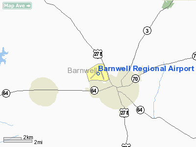
| Serves |
Barnwell, South Carolina |
| Location |
Barnwell County, near Barnwell, South Carolina |
| Elevation AMSL |
246 ft / 75 m |
| Coordinates |
33°15′28″N 081°23′18″W / 33.25778°N 81.38833°W / 33.25778; -81.38833Coordinates: 33°15′28″N 081°23′18″W / 33.25778°N 81.38833°W / 33.25778; -81.38833 |
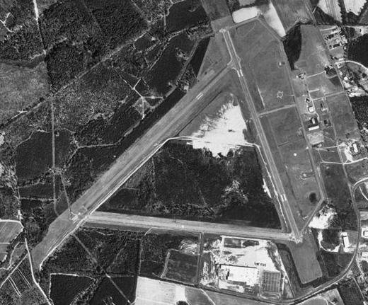
| Runways |
| Direction |
Length |
Surface |
| ft |
m |
| 5/23 |
5,255 |
1,602 |
Asphalt |
| 17/35 |
5,119 |
1,560 |
Asphalt |
Barnwell Regional Airport (IATA: BNL, ICAO: KBNL) is a public airport located 1 mile northwest of Barnwell, South Carolina. The airport serves the general aviation community, with no scheduled commercial airline service. History
The airport was built by the United States Army Air Forces and opened in May 1943. Barnwell Army Airfield was a satellite airfield of Columbia Army Air Base, supporting B-25 Mitchell medium bomber training for Third Air Force III Air Support Command. Training was accomplished by 44th Station Compliment Squadron which also maintained the facility. After the war, the airfield was turned over to local authorities which converted it into a civil airport.
The above content comes from Wikipedia and is published under free licenses – click here to read more.
Location & QuickFacts
| FAA Information Effective: | 2008-09-25 |
| Airport Identifier: | BNL |
| Airport Status: | Operational |
| Longitude/Latitude: | 081-23-18.0000W/33-15-28.0000N
-81.388333/33.257778 (Estimated) |
| Elevation: | 246 ft / 74.98 m (Surveyed) |
| Land: | 1163 acres |
| From nearest city: | 1 nautical miles NW of Barnwell, SC |
| Location: | Barnwell County, SC |
| Magnetic Variation: | 05W (1990) |
Owner & Manager
| Ownership: | Publicly owned |
| Owner: | Barnwell County |
| Address: | County Courthouse
Barnwell, SC 29812 |
| Phone number: | 803-541-1000 |
| Manager: | John Boney
CHAIRMAN. |
| Address: | 10404 Dunbartan Blvd., Po Box 899
Barnwell, SC 29812 |
| Phone number: | 803-259-7998 |
Airport Operations and Facilities
| Airport Use: | Open to public |
| Wind indicator: | Yes |
| Segmented Circle: | Yes |
| Control Tower: | No |
| Lighting Schedule: | DUSK-DAWN |
| Beacon Color: | Clear-Green (lighted land airport) |
| Landing fee charge: | No |
| Sectional chart: | Atlanta |
| Region: | ASO - Southern |
| Boundary ARTCC: | ZJX - Jacksonville |
| Tie-in FSS: | AND - Anderson |
| FSS on Airport: | No |
| FSS Toll Free: | 1-800-WX-BRIEF |
| NOTAMs Facility: | AND (NOTAM-d service avaliable) |
| Federal Agreements: | NGRY |
Airport Communications
| CTAF: | 122.800 |
| Unicom: | 122.800 |
Airport Services
| Fuel available: | 100LLA
SELF SVC FUEL. |
| Airframe Repair: | MAJOR |
| Power Plant Repair: | MAJOR |
| Bottled Oxygen: | NONE |
| Bulk Oxygen: | NONE |
Runway Information
Runway 05/23
| Dimension: | 5255 x 70 ft / 1601.7 x 21.3 m |
| Surface: | ASPH, Poor Condition
RWY 05/23 PAVEMENT CRACKED WITH GRASS GROWING THROUGH PRODUCING LOOSE STONES. |
| Weight Limit: | Single wheel: 12000 lbs. |
| |
Runway 05 |
Runway 23 |
| Longitude: | 081-23-54.0300W | 081-23-09.9710W |
| Latitude: | 33-15-09.3120N | 33-15-45.8210N |
| Elevation: | 242.00 ft | 240.00 ft |
| Alignment: | 45 | 127 |
| Traffic Pattern: | Right | Left |
| Markings: | Non-precision instrument, Poor Condition
RUNWAY MARKINGS FADED. | Non-precision instrument, Poor Condition
RUNWAY MARKINGS FADED. |
| Runway End Identifier: | No | No |
| Centerline Lights: | No | No |
| Touchdown Lights: | No | No |
| Obstruction: | 56 ft tree, 750.0 ft from runway, 274 ft right of centerline, 9:1 slope to clear | 108 ft tree, 2398.0 ft from runway, 279 ft right of centerline, 20:1 slope to clear |
|
Runway 17/35
| Dimension: | 5119 x 100 ft / 1560.3 x 30.5 m |
| Surface: | ASPH, Good Condition
RWY 05/23 PAVEMENT CRACKED WITH GRASS GROWING THROUGH PRODUCING LOOSE STONES. |
| Weight Limit: | Single wheel: 20000 lbs.
Dual wheel: 60000 lbs. |
| Edge Lights: | Medium |
| |
Runway 17 |
Runway 35 |
| Longitude: | 081-23-13.8080W | 081-22-53.6060W |
| Latitude: | 33-15-52.3900N | 33-15-04.6790N |
| Elevation: | 236.00 ft | 245.00 ft |
| Alignment: | 127 | 127 |
| Traffic Pattern: | Right | Left |
| Markings: | Non-precision instrument, Good Condition | Non-precision instrument, Good Condition |
| Crossing Height: | 52.00 ft | 45.00 ft |
| VASI: | 2-light PAPI on left side | 2-light PAPI on left side |
| Visual Glide Angle: | 3.00° | 3.00° |
| Approach lights: | ODALS | |
| Runway End Identifier: | Yes | No |
| Centerline Lights: | No | No |
| Touchdown Lights: | No | No |
| Obstruction: | 104 ft tree, 3168.0 ft from runway, 341 ft left of centerline, 28:1 slope to clear | 64 ft tree, 1772.0 ft from runway, 341 ft right of centerline, 24:1 slope to clear |
|
Radio Navigation Aids
| ID |
Type |
Name |
Ch |
Freq |
Var |
Dist |
| BKO | NDB | Barnwell | | 392.00 | 06W | 5.6 nm |
| OYI | NDB | Orangeburg | | 226.00 | 05W | 26.1 nm |
| AIK | NDB | Aiken | | 347.00 | 04W | 27.8 nm |
| EMR | NDB | Emory | | 385.00 | 04W | 32.9 nm |
| BXG | NDB | Burke County | | 356.00 | 04W | 33.6 nm |
| LNH | NDB | Millen | | 205.00 | 05W | 36.4 nm |
| JYL | NDB | Sylvania | | 245.00 | 04W | 38.0 nm |
| RBW | NDB | Walterboro | | 221.00 | 05W | 42.6 nm |
| ALD | VOR | Allendale | | 116.70 | 01W | 15.5 nm |
| EDS | VOR/DME | Edisto | 051X | 111.40 | 05W | 29.1 nm |
| CAE | VORTAC | Columbia | 094X | 114.70 | 02W | 39.7 nm |
| IRQ | VORTAC | Colliers | 086X | 113.90 | 04W | 47.3 nm |
| VAN | VORTAC | Vance | 041X | 110.40 | 06W | 48.9 nm |
| MMT | VORTAC | Mc Entire | 079X | 113.20 | 05W | 49.7 nm |
Remarks
- ARPT EXISTED PRIOR TO 1958
Images and information placed above are from
http://www.airport-data.com/airport/BNL/
We thank them for the data!
| General Info
|
| Country |
United States
|
| State |
SOUTH CAROLINA
|
| FAA ID |
BNL
|
| Latitude |
33-15-28.000N
|
| Longitude |
081-23-18.000W
|
| Elevation |
246 feet
|
| Near City |
BARNWELL
|
We don't guarantee the information is fresh and accurate. The data may
be wrong or outdated.
For more up-to-date information please refer to other sources.
|
|


