 |
|
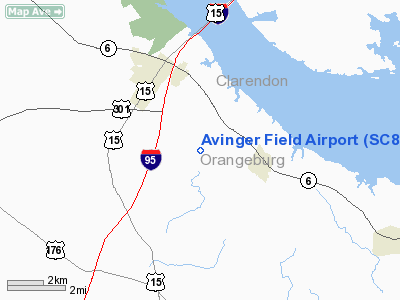
Location & QuickFacts
| FAA Information Effective: | 2008-09-25 |
| Airport Identifier: | SC87 |
| Airport Status: | Operational |
| Longitude/Latitude: | 080-27-20.0000W/33-26-34.0000N
-80.455556/33.442778 (Estimated) |
| Elevation: | 138 ft / 42.06 m (Estimated) |
| Land: | 0 acres |
| From nearest city: | 1 nautical miles NW of Vance, SC |
| Location: | Orangeburg County, SC |
| Magnetic Variation: | 05W (1990) |
Owner & Manager
| Ownership: | Privately owned |
| Owner: | Ira D Avinger Sr |
| Address: | Route 1 Box 822
Vance, SC 29163 |
| Phone number: | 803-492-7839 |
| Manager: | Ira D Avinger Sr |
| Address: | Route 1 Box 822
Vance, SC 29163 |
| Phone number: | 803-492-7839 |
Airport Operations and Facilities
| Airport Use: | Private |
| Segmented Circle: | No |
| Control Tower: | No |
| Sectional chart: | Charlotte |
| Region: | ASO - Southern |
| Boundary ARTCC: | ZJX - Jacksonville |
| Tie-in FSS: | AND - Anderson |
| FSS Toll Free: | 1-800-WX-BRIEF |
Runway Information
Runway 13/31
| Dimension: | 3000 x 100 ft / 914.4 x 30.5 m |
| Surface: | TURF, |
| |
Runway 13 |
Runway 31 |
| Traffic Pattern: | Left | Left |
| Obstruction: | 100 ft trees, 1500.0 ft from runway | 100 ft trees, 1500.0 ft from runway |
|
Radio Navigation Aids
| ID |
Type |
Name |
Ch |
Freq |
Var |
Dist |
| MNI | NDB | Manning | | 381.00 | 06W | 15.3 nm |
| OYI | NDB | Orangeburg | | 226.00 | 05W | 22.6 nm |
| DYB | NDB | Dorchester County | | 365.00 | 05W | 24.6 nm |
| MKS | NDB | Moncks Corner | | 354.00 | 05W | 26.1 nm |
| RBW | NDB | Walterboro | | 221.00 | 05W | 32.4 nm |
| SMS | NDB | Sumter | | 252.00 | 04W | 33.3 nm |
| CH | NDB | Ashly | | 329.00 | 05W | 33.3 nm |
| MMT | NDB | Mc Entire | | 427.00 | 05W | 34.2 nm |
| CKI | NDB | Kingstree | | 404.00 | 06W | 34.3 nm |
| CFY | NDB | Evans | | 420.00 | 06W | 42.5 nm |
| PHH | NDB | Andrews | | 255.00 | 06W | 46.6 nm |
| BKO | NDB | Barnwell | | 392.00 | 06W | 48.9 nm |
| HEK | NDB | Stuckey | | 236.00 | 06W | 49.7 nm |
| JZI | NDB | Johns Island | | 283.00 | 05W | 50.0 nm |
| SSC | TACAN | Shaw | 038X | | 05W | 32.2 nm |
| ALD | VOR | Allendale | | 116.70 | 01W | 49.4 nm |
| EDS | VOR/DME | Edisto | 051X | 111.40 | 05W | 20.2 nm |
| VAN | VORTAC | Vance | 041X | 110.40 | 06W | 2.0 nm |
| MMT | VORTAC | Mc Entire | 079X | 113.20 | 05W | 33.7 nm |
| CAE | VORTAC | Columbia | 094X | 114.70 | 02W | 38.9 nm |
| CHS | VORTAC | Charleston | 082X | 113.50 | 05W | 39.1 nm |
| CHS | VOT | Charleston | | 111.00 | | 38.4 nm |
Remarks
Images and information placed above are from
http://www.airport-data.com/airport/SC87/
We thank them for the data!
| General Info
|
| Country |
United States
|
| State |
SOUTH CAROLINA
|
| FAA ID |
SC87
|
| Latitude |
33-26-34.000N
|
| Longitude |
080-27-20.000W
|
| Elevation |
138 feet
|
| Near City |
VANCE
|
We don't guarantee the information is fresh and accurate. The data may
be wrong or outdated.
For more up-to-date information please refer to other sources.
|
|


