 |
|
| Aiken Municipal Airport |
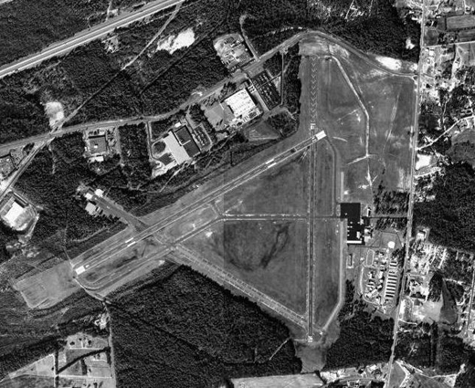 |
| USGS aerial image as of 19 January 1994 |
| IATA: AIK – ICAO: KAIK – FAA LID: AIK |
| Summary |
| Airport type |
Public |
| Owner |
City of Aiken |
| Serves |
Aiken, South Carolina |
| Location |
Aiken County, near Aiken, South Carolina |
| Elevation AMSL |
528 ft / 161 m |
| Coordinates |
33°38′58″N 081°41′06″W / 33.64944°N 81.685°W / 33.64944; -81.685 |
| Website |
CityOfAikenSC.gov/... |
| Runways |
| Direction |
Length |
Surface |
| ft |
m |
| 7/25 |
5,500 |
1,676 |
Asphalt |
| 1/19 |
3,800 |
1,158 |
Asphalt |
| Statistics (2008) |
| Aircraft operations |
43,900 |
| Based aircraft |
53 |
| Source: Federal Aviation Administration |
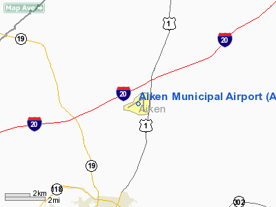
Aiken Municipal Airport (IATA: AIK, ICAO: KAIK, FAA LID: AIK) is a city-owned public-use airport located five nautical miles (9 km) north of the central business district of Aiken, a city in Aiken County, South Carolina, United States. The airport serves the general aviation community, with no scheduled commercial airline service. History
The airport was built by the United States Army Air Forces and named Aiken Army Airfield. It opened on 24 December 1942 as a satellite airfield of Morris Army Airfield, North Carolina. It was assigned to Third Air Force, III Tactical Air Command as a group training airfield for reconnaissance units.
The formal activation date of the airfield was 23 June 1943 when the 66th Tactical Reconnaissance Group arrived along with subordinate units of the 97th Tactical Reconnaissance Squadron and 19th Liaison squadron. The 118th Tactical Reconnaissance Squadron arrived on 29 August 1943.
The airfield was reassigned to First Air Force on 10 January 1944 and the 359th Army Air Force Base Unit was assigned host unit. The airfield became a replacement training airfield for single-engine fighter pilots, training on P-40 Warhawk and P-51 Mustang aircraft, beginning on 19 October 1944. Active flying at the airfield ended on 28 February 1945, and the base was turned over to Air Technical Service Command for disposition on 31 March 1945.
The airfield was turned over to local government authorities afterward and was converted into a civil airport.
Facilities and aircraft
Aiken Municipal Airport covers an area of 700 acres (283 ha) at an elevation of 528 feet (161 m) above mean sea level. It has two asphalt paved runways: 7/25 is 5,500 by 100 feet (1,676 x 30 m) and 1/19 is 3,800 by 75 feet (1,158 x 23 m).
For the 12-month period ending July 24, 2008, the airport had 43,900 aircraft operations, an average of 120 per day: 93% general aviation, 6% air taxi and 1% military. At that time there were 53 aircraft based at this airport: 70% single-engine, 23% multi-engine and 7% jet.
The above content comes from Wikipedia and is published under free licenses – click here to read more.
Location & QuickFacts
| FAA Information Effective: | 2008-09-25 |
| Airport Identifier: | AIK |
| Airport Status: | Operational |
| Longitude/Latitude: | 081-41-06.1305W/33-38-57.7530N
-81.685036/33.649376 (Estimated) |
| Elevation: | 528 ft / 160.93 m (Surveyed) |
| Land: | 700 acres |
| From nearest city: | 5 nautical miles N of Aiken, SC |
| Location: | Aiken County, SC |
| Magnetic Variation: | 06W (2005) |
Owner & Manager
| Ownership: | Publicly owned |
| Owner: | City Of Aiken |
| Address: | Po Box 1177
Aiken, SC 29801 |
| Phone number: | 803-648-7654 |
| Manager: | Larry Morris
FBO MGR, BETH NORTH, AIKEN AVIATION 803-648-7803. |
| Address: | Director Of Public Works, Po Box 1177
Aiken, SC 29802 |
| Phone number: | 803-642-7610 |
Airport Operations and Facilities
| Airport Use: | Open to public |
| Wind indicator: | Yes |
| Segmented Circle: | Yes |
| Control Tower: | No |
| Lighting Schedule: | DUSK-DAWN
ACTIVATE MIRL RY 07/25 AND ODALS RY 25 - CTAF. |
| Beacon Color: | Clear-Green (lighted land airport) |
| Landing fee charge: | No |
| Sectional chart: | Atlanta |
| Region: | ASO - Southern |
| Boundary ARTCC: | ZJX - Jacksonville |
| Responsible ARTCC: | ZTL - Atlanta |
| Tie-in FSS: | AND - Anderson |
| FSS on Airport: | No |
| FSS Toll Free: | 1-800-WX-BRIEF |
| NOTAMs Facility: | AND (NOTAM-d service avaliable) |
| Federal Agreements: | NGRY3 |
Airport Communications
| CTAF: | 122.800 |
| Unicom: | 122.800
ALTIMETER SETTING AVBL ON 122.8. |
Airport Services
| Fuel available: | 100LLA |
| Bottled Oxygen: | NONE |
| Bulk Oxygen: | NONE |
Runway Information
Runway 01/19
| Dimension: | 3800 x 75 ft / 1158.2 x 22.9 m |
| Surface: | ASPH, Good Condition |
| Surface Treatment: | Aggregate Friction Seal Coat |
| Weight Limit: | Single wheel: 22000 lbs. |
| Edge Lights: | Medium |
| |
Runway 01 |
Runway 19 |
| Longitude: | 081-40-51.2000W | 081-40-50.9100W |
| Latitude: | 33-38-36.6900N | 33-39-14.2700N |
| Elevation: | 528.00 ft | 493.00 ft |
| Alignment: | 0 | 127 |
| Traffic Pattern: | Left | Left |
| Markings: | Basic, Good Condition | Basic, Good Condition |
| Obstruction: | 16 ft tree, 575.0 ft from runway, 85 ft left of centerline, 23:1 slope to clear | 27 ft tree, 883.0 ft from runway, 138 ft right of centerline, 25:1 slope to clear |
|
Runway 07/25
| Dimension: | 5500 x 100 ft / 1676.4 x 30.5 m |
| Surface: | ASPH, Good Condition |
| Weight Limit: | Single wheel: 22000 lbs.
Dual wheel: 65000 lbs. |
| Edge Lights: | Medium |
| |
Runway 07 |
Runway 25 |
| Longitude: | 081-41-44.8125W | 081-40-48.2801W |
| Latitude: | 33-38-45.8555N | 33-39-12.7914N |
| Elevation: | 515.00 ft | 494.00 ft |
| Alignment: | 60 | 127 |
| Traffic Pattern: | Left | Left |
| Markings: | Non-precision instrument, Good Condition | Precision instrument, Good Condition |
| Crossing Height: | 22.00 ft | 26.00 ft |
| VASI: | 2-light PAPI on left side | 2-light PAPI on left side |
| Visual Glide Angle: | 3.00° | 3.00° |
| Approach lights: | | ODALS |
| Runway End Identifier: | | Yes |
| Obstruction: | , 50:1 slope to clear | 65 ft tree, 2315.0 ft from runway, 570 ft left of centerline, 32:1 slope to clear |
|
Radio Navigation Aids
| ID |
Type |
Name |
Ch |
Freq |
Var |
Dist |
| AIK | NDB | Aiken | | 347.00 | 04W | 0.4 nm |
| EMR | NDB | Emory | | 385.00 | 04W | 19.2 nm |
| BKO | NDB | Barnwell | | 392.00 | 06W | 22.4 nm |
| BXG | NDB | Burke County | | 356.00 | 04W | 39.9 nm |
| EOE | NDB | Enoree | | 278.00 | 05W | 39.9 nm |
| OYI | NDB | Orangeburg | | 226.00 | 05W | 41.4 nm |
| GIW | NDB | Coronaca | | 239.00 | 04W | 41.5 nm |
| HQU | NDB | Thomson-mcduffie | | 333.00 | 04W | 42.2 nm |
| AA | NDB | Cedar | | 341.00 | 04W | 47.1 nm |
| MMT | NDB | Mc Entire | | 427.00 | 05W | 47.5 nm |
| LNH | NDB | Millen | | 205.00 | 05W | 47.5 nm |
| FDW | NDB | Winnsboro | | 414.00 | 05W | 49.1 nm |
| ALD | VOR | Allendale | | 116.70 | 01W | 43.1 nm |
| EDS | VOR/DME | Edisto | 051X | 111.40 | 05W | 43.0 nm |
| IRQ | VORTAC | Colliers | 086X | 113.90 | 04W | 24.1 nm |
| CAE | VORTAC | Columbia | 094X | 114.70 | 02W | 33.9 nm |
| GRD | VORTAC | Greenwood | 102X | 115.50 | 01W | 43.1 nm |
| MMT | VORTAC | Mc Entire | 079X | 113.20 | 05W | 47.1 nm |
Images and information placed above are from
http://www.airport-data.com/airport/AIK/
We thank them for the data!
| General Info
|
| Country |
United States
|
| State |
SOUTH CAROLINA
|
| FAA ID |
AIK
|
| Latitude |
33-38-58.400N
|
| Longitude |
081-41-04.100W
|
| Elevation |
528 feet
|
| Near City |
AIKEN
|
We don't guarantee the information is fresh and accurate. The data may
be wrong or outdated.
For more up-to-date information please refer to other sources.
|
|


