 |
|
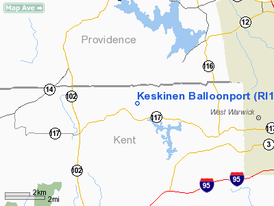
Keskinen Balloonport Airport |
Location & QuickFacts
| FAA Information Effective: | 2008-09-25 |
| Airport Identifier: | RI16 |
| Airport Status: | Operational |
| Longitude/Latitude: | 071-38-14.2340W/41-42-53.3590N
-71.637287/41.714822 (Estimated) |
| Elevation: | 255 ft / 77.72 m (Estimated) |
| Land: | 0 acres |
| From nearest city: | 1 nautical miles N of Coventry Center, RI |
| Location: | Kent County, RI |
| Magnetic Variation: | 15W (1985) |
Owner & Manager
| Ownership: | Privately owned |
| Owner: | Oliver J. Keskinen |
| Address: | 802 Town Farm Road
Coventry, RI 02816 |
| Phone number: | 401-397-5506 |
| Manager: | Oliver J. Keskinen |
| Address: | 802 Town Farm Road
Coventry, RI 02816 |
| Phone number: | 401-397-5506 |
Airport Operations and Facilities
| Airport Use: | Private |
| Wind indicator: | No |
| Segmented Circle: | No |
| Control Tower: | No |
| Landing fee charge: | No |
| Sectional chart: | New York |
| Region: | ANE - New England |
| Boundary ARTCC: | ZBW - Boston |
| Tie-in FSS: | BDR - Bridgeport |
| FSS on Airport: | No |
| FSS Toll Free: | 1-800-WX-BRIEF |
Runway Information
Balloonport B1
| Dimension: | 600 x 300 ft / 182.9 x 91.4 m |
| Surface: | TURF, |
| |
Runway B1 |
Runway |
| Traffic Pattern: | Left | Left |
|
Radio Navigation Aids
| ID |
Type |
Name |
Ch |
Freq |
Var |
Dist |
| ORW | FAN MARKER | Canton | | | 15W | 34.4 nm |
| SFZ | NDB | Central | | 241.00 | 15W | 14.0 nm |
| IHM | NDB | Mansfield | | 220.00 | 16W | 26.2 nm |
| TAN | NDB | Taunton | | 227.00 | 16W | 29.4 nm |
| FFF | NDB | Plymouth | | 257.00 | 16W | 38.2 nm |
| HF | NDB | Lomis | | 244.00 | 15W | 44.6 nm |
| IMR | NDB | Marshfield | | 368.00 | 16W | 48.8 nm |
| SKR | NDB | Shaker Hill | | 251.00 | 16W | 49.0 nm |
| NZW | TACAN | South Weymouth | 061X | | 15W | 40.7 nm |
| PUT | VOR/DME | Putnam | 121X | 117.40 | 14W | 17.2 nm |
| ORW | VOR/DME | Norwich | 037X | 110.00 | 14W | 18.8 nm |
| GON | VOR/DME | Groton | 45Y | 110.85 | 14W | 29.7 nm |
| SEY | VOR/DME | Sandy Point | 125X | 117.80 | 15W | 33.0 nm |
| HFD | VOR/DME | Hartford | 096X | 114.90 | 13W | 41.1 nm |
| MVY | VOR/DME | Marthas Vineyard | 092X | 114.50 | 15W | 49.9 nm |
| PVD | VORTAC | Providence | 103X | 115.60 | 14W | 9.3 nm |
| BOS | VORTAC | Boston | 074X | 112.70 | 16W | 48.3 nm |
| BDL | VORTAC | Bradley | 027X | 109.00 | 14W | 49.0 nm |
| CEF | VORTAC | Westover | 87X | 114.00 | 14W | 49.2 nm |
| PVD | VOT | Providence | | 108.20 | | 9.5 nm |
| GON | VOT | Groton | | 110.25 | | 29.9 nm |
| ORH | VOT | Worcester | | 108.20 | | 34.8 nm |
| HFD | VOT | Hartford | | 108.20 | | 45.5 nm |
| BED | VOT | Laurence G Hanscom Fld | | 110.00 | | 47.9 nm |
| BOS | VOT | Boston Logan Intl | | 111.00 | | 48.4 nm |
| BDL | VOT | Bradley Intl | | 111.40 | | 48.7 nm |
Remarks
Images and information placed above are from
http://www.airport-data.com/airport/RI16/
We thank them for the data!
| General Info
|
| Country |
United States
|
| State |
RHODE ISLAND
|
| FAA ID |
RI16
|
| Latitude |
41-42-53.359N
|
| Longitude |
071-38-14.234W
|
| Elevation |
255 feet
|
| Near City |
COVENTRY CENTER
|
We don't guarantee the information is fresh and accurate. The data may
be wrong or outdated.
For more up-to-date information please refer to other sources.
|
|


