 |
|
| Zelienople Municipal Airport |
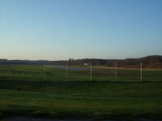 |
| Runway at Zelienople Municipal Airport |
| IATA: none – ICAO: none – FAA LID: PJC |
| Summary |
| Airport type |
Public |
| Owner |
Airport Authority of Zelienople Borough |
| Serves |
Zelienople, Pennsylvania |
| Location |
Franklin Township, Pennsylvania |
| Elevation AMSL |
901 ft / 274.6 m |
| Coordinates |
40°48′06″N 080°09′39″W / 40.80167°N 80.16083°W / 40.80167; -80.16083 |
| Runways |
| Direction |
Length |
Surface |
| ft |
m |
| 17/35 |
4,102 |
1,250 |
Asphalt |
| Statistics (2007) |
| Aircraft operations |
31,025 |
| Based aircraft |
48 |
| Source: Federal Aviation Administration |
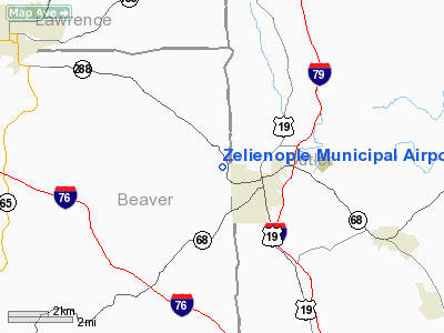
Zelienople Airport (FAA LID: PJC), is a public airport located 1 mile west of Zelienople, Pennsylvania, USA. Though it primarily serves the community of Zelienople (in Butler County), the airport is actually located over the county line in neighboring Beaver County. The Zelienople Municipal Airport is located in Fombell, PA Franklin Township. Fire response consists of 2 Engines, 1 Tanker, 1 Brush Truck, 1 Squad, and Command Vehicle. The airport is between PA 288 and PA 588. The airport began service in 1958, and is one of the many medium sized airports located north of the city of Pittsburgh.
The above content comes from Wikipedia and is published under free licenses – click here to read more.
Location & QuickFacts
| FAA Information Effective: | 2008-09-25 |
| Airport Identifier: | PJC |
| Airport Status: | Operational |
| Longitude/Latitude: | 080-09-38.6240W/40-48-05.8300N
-80.160729/40.801619 (Estimated) |
| Elevation: | 901 ft / 274.62 m (Surveyed) |
| Land: | 204 acres |
| From nearest city: | 1 nautical miles W of Zelienople, PA |
| Location: | Beaver County, PA |
| Magnetic Variation: | 09W (2000) |
Owner & Manager
| Ownership: | Publicly owned |
| Owner: | Arpt Auth Boro Zelienople |
| Address: | 1857 Route 588
Zelienople, PA 16063 |
| Phone number: | 724-452-1290 |
| Manager: | Dave Holman |
| Address: | 1857 Route 588
Zelienople, PA 16063 |
| Phone number: | 724-452-4719 |
Airport Operations and Facilities
| Airport Use: | Open to public |
| Wind indicator: | Yes |
| Segmented Circle: | Yes |
| Control Tower: | No |
| Lighting Schedule: | DUSK-DAWN
MIRL RY 17/35 OPER DUSK-2200, AFTER 2200 ACTVT MIRL RY 17/35 - CTAF. |
| Beacon Color: | Clear-Green (lighted land airport) |
| Landing fee charge: | No |
| Sectional chart: | Detroit |
| Region: | AEA - Eastern |
| Boundary ARTCC: | ZOB - Cleveland |
| Tie-in FSS: | AOO - Altoona |
| FSS on Airport: | No |
| FSS Toll Free: | 1-800-WX-BRIEF |
| NOTAMs Facility: | AOO (NOTAM-d service avaliable) |
| Federal Agreements: | NGY |
Airport Communications
Airport Services
| Fuel available: | 100LLA |
| Airframe Repair: | MINOR |
| Power Plant Repair: | MINOR |
| Bottled Oxygen: | HIGH |
| Bulk Oxygen: | LOW |
Runway Information
Runway 17/35
| Dimension: | 4102 x 75 ft / 1250.3 x 22.9 m |
| Surface: | ASPH, Fair Condition
TRANSVERSE CRACK NEAR TAXIWAY A2. |
| Edge Lights: | Medium |
| |
Runway 17 |
Runway 35 |
| Longitude: | 080-09-45.3560W | 080-09-31.8930W |
| Latitude: | 40-48-25.4380N | 40-47-46.2220N |
| Elevation: | 895.00 ft | 901.00 ft |
| Alignment: | 127 | 127 |
| Traffic Pattern: | Left | Left |
| Markings: | Non-precision instrument, Good Condition
RY 17 MKGS FADED. | Non-precision instrument, Good Condition
RY 35 MKGS FADED. |
| Runway End Identifier: | | Yes |
| Obstruction: | 64 ft hill, 389.0 ft from runway, 166 ft left of centerline, 2:1 slope to clear
RY 17 HAS +78 FT POLE, DIST 1,043 FT, 162 FT LEFT, 13:1 BASED ON DSPLCD THLD.
RY 17 HAS +4 FT FENCE, 106 FT FM RY END, BOTH SIDES OF CTRLN. | 70 ft trees, 450.0 ft from runway, 234 ft left of centerline, 3:1 slope to clear
RY 35 HAS 10:1 TO DSPLCD THLD. |
|
Radio Navigation Aids
| ID |
Type |
Name |
Ch |
Freq |
Var |
Dist |
| UCP | NDB | Castle | | 272.00 | 09W | 17.6 nm |
| HBD | NDB | Hubbard | | 408.00 | 08W | 27.0 nm |
| MKP | NDB | Mc Keesport | | 287.00 | 07W | 31.9 nm |
| PNU | NDB | Washington County | | 255.00 | 08W | 39.5 nm |
| TSO | NDB | Tolson | | 395.00 | 07W | 44.2 nm |
| BHU | NDB | Benje | | 382.00 | 07W | 48.0 nm |
| FKL | VOR | Franklin | | 109.60 | 06W | 40.7 nm |
| AGC | VOR/DME | Allegheny | 037X | 110.00 | 09W | 31.9 nm |
| HLG | VOR/DME | Wheeling | 059X | 112.20 | 07W | 37.5 nm |
| CIP | VOR/DME | Clarion | 076X | 112.90 | 06W | 38.0 nm |
| EWC | VORTAC | Ellwood City | 105X | 115.80 | 08W | 2.7 nm |
| MMJ | VORTAC | Montour | 057X | 112.00 | 08W | 18.9 nm |
| YNG | VORTAC | Youngstown | 027X | 109.00 | 05W | 39.4 nm |
Remarks
- DEER & GEESE ON & INVOF RY.
- TWY LGTS TO HGR AREA ONLY. PARALLEL TWY MKD WITH REFLECTORS.
- VFR USE ONLY.
Images and information placed above are from
http://www.airport-data.com/airport/PJC/
We thank them for the data!
|
|


