 |
|
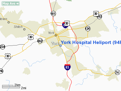
Location & QuickFacts
| FAA Information Effective: | 2008-09-25 |
| Airport Identifier: | 94PN |
| Airport Status: | Operational |
| Longitude/Latitude: | 076-43-04.8820W/39-56-45.3550N
-76.718023/39.945932 (Estimated) |
| Elevation: | 480 ft / 146.30 m (Estimated) |
| Land: | 0 acres |
| From nearest city: | 0 nautical miles SE of York, PA |
| Location: | York County, PA |
| Magnetic Variation: | 10W (1985) |
Owner & Manager
| Ownership: | Privately owned |
| Owner: | York Hospital |
| Address: | 1001 S George St
York, PA 17405 |
| Phone number: | 717-771-2673 |
| Manager: | Emergency, York Hospital |
| Address: | 1001 S George St
York, PA 17405 |
| Phone number: | 717-771-2450 |
Airport Operations and Facilities
| Airport Use: | Private
MEDICAL USE. |
| Wind indicator: | Yes |
| Segmented Circle: | No |
| Control Tower: | No |
| Lighting Schedule: | PHONE REQ
FOR PERIMETER LGTS CALL 717-771-2673. |
| Landing fee charge: | No |
| Sectional chart: | Washington |
| Region: | AEA - Eastern |
| Boundary ARTCC: | ZNY - New York |
| Tie-in FSS: | IPT - Williamsport |
| FSS on Airport: | No |
| FSS Toll Free: | 1-800-WX-BRIEF |
Airport Communications
Runway Information
Helipad H1
| Dimension: | 60 x 60 ft / 18.3 x 18.3 m |
| Surface: | CONC, |
| Edge Lights: | Low |
| |
Runway H1 |
Runway |
| Traffic Pattern: | Left | Left |
|
Radio Navigation Aids
| ID |
Type |
Name |
Ch |
Freq |
Var |
Dist |
| EUD | NDB | York | | 254.00 | 11W | 7.5 nm |
| BZJ | NDB | Bellgrove | | 328.00 | 10W | 30.4 nm |
| APG | NDB | Aberdeen | | 349.00 | 11W | 37.5 nm |
| FND | NDB | Ellicott | | 371.00 | 11W | 39.7 nm |
| IUB | NDB | Institute | | 404.00 | 08W | 39.8 nm |
| MTN | NDB | Martin | | 342.00 | 11W | 41.9 nm |
| MTN | TACAN | Martin | 068X | | 11W | 39.6 nm |
| FDK | VOR | Frederick | | 109.00 | 08W | 44.2 nm |
| PPM | VOR/DME | Phillips | 021X | 108.40 | 09W | 38.3 nm |
| LRP | VORTAC | Lancaster | 120X | 117.30 | 09W | 22.3 nm |
| HAR | VORTAC | Harrisburg | 072X | 112.50 | 10W | 26.8 nm |
| EMI | VORTAC | Westminster | 126X | 117.90 | 08W | 29.7 nm |
| RAV | VORTAC | Ravine | 093X | 114.60 | 11W | 36.9 nm |
| BAL | VORTAC | Baltimore | 098X | 115.10 | 11W | 46.7 nm |
| MXE | VORTAC | Modena | 079X | 113.20 | 09W | 48.3 nm |
| MDT | VOT | Harrisburg International | | 110.00 | | 15.3 nm |
Images and information placed above are from
http://www.airport-data.com/airport/94PN/
We thank them for the data!
| General Info
|
| Country |
United States
|
| State |
PENNSYLVANIA
|
| FAA ID |
94PN
|
| Latitude |
39-56-45.355N
|
| Longitude |
076-43-04.882W
|
| Elevation |
480 feet
|
| Near City |
YORK
|
We don't guarantee the information is fresh and accurate. The data may
be wrong or outdated.
For more up-to-date information please refer to other sources.
|
|


