 |
|
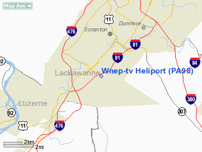
Location & QuickFacts
| FAA Information Effective: | 2008-09-25 |
| Airport Identifier: | PA98 |
| Airport Status: | Operational |
| Longitude/Latitude: | 075-40-50.6850W/41-22-12.2890N
-75.680746/41.370080 (Estimated) |
| Elevation: | 1035 ft / 315.47 m (Estimated) |
| Land: | 0 acres |
| From nearest city: | 1 nautical miles E of Moosic, PA |
| Location: | Lackawanna County, PA |
| Magnetic Variation: | 12W (1985) |
Owner & Manager
| Ownership: | Privately owned |
| Owner: | Wnep-tv |
| Address: | 16 Montage Mountain Rd
Moosic, PA 18507 |
| Phone number: | 717-346-7474 |
| Manager: | Elden A. Hale, Jr |
| Address: | 16 Montage Mountain Rd
Moosic, PA 18507 |
| Phone number: | 717-346-7474 |
Airport Operations and Facilities
| Airport Use: | Private |
| Wind indicator: | Yes |
| Segmented Circle: | No |
| Control Tower: | No |
| Sectional chart: | New York |
| Region: | AEA - Eastern |
| Boundary ARTCC: | ZNY - New York |
| Tie-in FSS: | IPT - Williamsport |
| FSS Toll Free: | 1-800-WX-BRIEF |
Runway Information
Helipad H1
| Dimension: | 60 x 60 ft / 18.3 x 18.3 m |
| Surface: | CONC, |
| |
Runway H1 |
Runway |
| Traffic Pattern: | Left | Left |
|
Radio Navigation Aids
| ID |
Type |
Name |
Ch |
Freq |
Var |
Dist |
| CYE | NDB | Crystal Lake | | 410.00 | 11W | 11.8 nm |
| HXM | NDB | Humbolt | | 366.00 | 10W | 27.0 nm |
| LQX | NDB | Carbon | | 339.00 | 12W | 33.7 nm |
| MS | NDB | Monga | | 359.00 | 12W | 43.9 nm |
| PIX | NDB | Picture Rocks | | 344.00 | 09W | 46.8 nm |
| HZL | VOR | Hazleton | | 109.40 | 09W | 31.1 nm |
| STW | VOR/DME | Stillwater | 033X | 109.60 | 11W | 43.1 nm |
| HNK | VOR/DME | Hancock | 115X | 116.80 | 11W | 44.7 nm |
| ETX | VOR/DME | East Texas | 039X | 110.20 | 09W | 47.4 nm |
| HUO | VOR/DME | Huguenot | 108X | 116.10 | 11W | 49.2 nm |
| FQM | VOR/DME | Williamsport | 091X | 114.40 | 09W | 49.4 nm |
| LVZ | VORTAC | Wilkes-barre | 053X | 111.60 | 10W | 5.9 nm |
| LHY | VORTAC | Lake Henry | 045X | 110.80 | 10W | 11.0 nm |
| FJC | VORTAC | Allentown | 122X | 117.50 | 10W | 40.0 nm |
| MIP | VORTAC | Milton | 029X | 109.20 | 09W | 49.2 nm |
Remarks
- APCH 170 DEGS - DEPART 350 DEGS; APCH 080 DEGS - DEPART 260 DEGS.
- TALL LGT STANDARDS IN CENTER OF INTERSTATE.
- CTC MGR OF WILKES-BARRE ATCT PRIOR TO OPNS AND ENTER INTO LTR OF AGREEMENT; PILOTS BE BRIEFED REGARDING OPNL PROCEDURES.
Images and information placed above are from
http://www.airport-data.com/airport/PA98/
We thank them for the data!
| General Info
|
| Country |
United States
|
| State |
PENNSYLVANIA
|
| FAA ID |
PA98
|
| Latitude |
41-22-12.289N
|
| Longitude |
075-40-50.685W
|
| Elevation |
1035 feet
|
| Near City |
MOOSIC
|
We don't guarantee the information is fresh and accurate. The data may
be wrong or outdated.
For more up-to-date information please refer to other sources.
|
|


