 |
|
Wilkes-barre Wyoming Valley Airport |
| Wilkes-Barre Wyoming Valley Airport |
| IATA: WBW – ICAO: KWBW |
| Summary |
| Airport type |
Public |
| Owner |
Luzerne County |
| Location |
Wilkes-Barre, Pennsylvania |
| Elevation AMSL |
545 ft / 166.1 m |
| Coordinates |
41°17′49.82″N 75°51′04.34″W / 41.2971722°N 75.8512056°W / 41.2971722; -75.8512056 |
| Runways |
| Direction |
Length |
Surface |
| ft |
m |
| 7/25 |
3,376 |
1,029 |
Asphalt |
| 9/27 |
2,200 |
671 |
Asphalt/Turf |
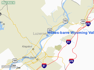
Wilkes-Barre Wyoming Valley Airport (IATA: WBW, ICAO: KWBW) is a public airport located in Forty Fort, Pennsylvania, 3 miles (5 km) north of the city of Wilkes-Barre in the Wyoming Valley region of northeastern Pennsylvania.
Facilities
Wilkes-Barre Wyoming Valley Airport covers 135 acres (0.55 km) and has two runways:
- Runway 7/25: 3,376 x 75 ft (1,029 x 23 m), Surface: Asphalt
- Runway 9/27: 2,200 x 100 ft (671 x 30 m), Surface: Asphalt/Turf
The above content comes from Wikipedia and is published under free licenses – click here to read more.
Location & QuickFacts
| FAA Information Effective: | 2008-09-25 |
| Airport Identifier: | WBW |
| Airport Status: | Operational |
| Longitude/Latitude: | 075-51-04.3400W/41-17-49.8200N
-75.851206/41.297172 (Estimated) |
| Elevation: | 545 ft / 166.12 m (Surveyed) |
| Land: | 135 acres |
| From nearest city: | 3 nautical miles N of Wilkes-barre, PA |
| Location: | Luzerne County, PA |
| Magnetic Variation: | 12W (1990) |
Owner & Manager
| Ownership: | Publicly owned |
| Owner: | County Of Luzerne |
| Address: | 200 N. River St.
Wilkes-barre, PA 18071 |
| Phone number: | 570-825-1600 |
| Manager: | Jim Scrobola |
| Address: | 2001 Wyoming Ave
Forty Fort, PA 18704 |
| Phone number: | 570-288-3257 |
Airport Operations and Facilities
| Airport Use: | Open to public |
| Wind indicator: | Yes |
| Segmented Circle: | Yes |
| Control Tower: | No |
| Lighting Schedule: | RDO-CTL
ACTVT MIRL RY 07/25, PAPI RYS 07 & 25, REIL RYS 07 & 25, ROTG BCN - CTAF RY 07/25 PRESET LOW INTST, TO ACTVT HIGHER INTST - CTAF. |
| Beacon Color: | Clear-Green (lighted land airport) |
| Landing fee charge: | No |
| Sectional chart: | New York |
| Region: | AEA - Eastern |
| Boundary ARTCC: | ZNY - New York |
| Tie-in FSS: | IPT - Williamsport |
| FSS on Airport: | No |
| FSS Toll Free: | 1-800-WX-BRIEF |
| NOTAMs Facility: | IPT (NOTAM-d service avaliable) |
| Federal Agreements: | NGY |
Airport Communications
| CTAF: | 122.800 |
| Unicom: | 122.800 |
Airport Services
| Fuel available: | 100LLA |
| Airframe Repair: | MAJOR |
| Power Plant Repair: | MAJOR |
| Bottled Oxygen: | NONE |
| Bulk Oxygen: | NONE |
Runway Information
Runway 07/25
| Dimension: | 3376 x 75 ft / 1029.0 x 22.9 m |
| Surface: | ASPH, Good Condition
FIRST 544 FT RY 27 ASPH; REMAINDER TURF. |
| Edge Lights: | Medium |
| |
Runway 07 |
Runway 25 |
| Longitude: | 075-51-22.1340W | 075-50-46.5430W |
| Latitude: | 41-17-39.9210N | 41-17-59.7180N |
| Elevation: | 544.00 ft | 543.00 ft |
| Alignment: | 54 | 127 |
| Traffic Pattern: | Left | Left |
| Markings: | Basic, Good Condition | Basic, Good Condition |
| Crossing Height: | 20.00 ft | 20.00 ft |
| VASI: | 2-light PAPI on left side | 2-light PAPI on left side |
| Visual Glide Angle: | 3.50° | 3.50° |
| Runway End Identifier: | Yes
RY 07 REIL OTS INDEFLY. | Yes
RY 25 REIL OTS INDEFLY. |
| Obstruction: | 95 ft trees, 1966.0 ft from runway, 172 ft left of centerline, 18:1 slope to clear | 14 ft berm, 507.0 ft from runway, 21:1 slope to clear |
|
Runway 09/27
| Dimension: | 2200 x 100 ft / 670.6 x 30.5 m |
| Surface: | ASPH-TURF, Good Condition
FIRST 544 FT RY 27 ASPH; REMAINDER TURF. |
| |
Runway 09 |
Runway 27 |
| Traffic Pattern: | Left | Left |
| Displaced threshold: | 660.00 ft | 0.00 ft |
| Obstruction: | 89 ft trees, 1226.0 ft from runway, 150 ft left of centerline, 13:1 slope to clear
APCH RATIO 21:1 TO DSPLCD THLD. | 61 ft trees, 1938.0 ft from runway, 101 ft left of centerline, 31:1 slope to clear |
|
Radio Navigation Aids
| ID |
Type |
Name |
Ch |
Freq |
Var |
Dist |
| CYE | NDB | Crystal Lake | | 410.00 | 11W | 5.3 nm |
| HXM | NDB | Humbolt | | 366.00 | 10W | 19.7 nm |
| LQX | NDB | Carbon | | 339.00 | 12W | 29.5 nm |
| PIX | NDB | Picture Rocks | | 344.00 | 09W | 38.8 nm |
| HZL | VOR | Hazleton | | 109.40 | 09W | 23.0 nm |
| FQM | VOR/DME | Williamsport | 091X | 114.40 | 09W | 41.8 nm |
| ETX | VOR/DME | East Texas | 039X | 110.20 | 09W | 43.7 nm |
| STW | VOR/DME | Stillwater | 033X | 109.60 | 11W | 48.0 nm |
| LVZ | VORTAC | Wilkes-barre | 053X | 111.60 | 10W | 7.5 nm |
| LHY | VORTAC | Lake Henry | 045X | 110.80 | 10W | 19.8 nm |
| FJC | VORTAC | Allentown | 122X | 117.50 | 10W | 38.7 nm |
| MIP | VORTAC | Milton | 029X | 109.20 | 09W | 40.3 nm |
Remarks
- HIGH TRANSMISSION LINES +152 FT; 6000 FT FM RY 25 THLD 585 FT L MKD WITH RED SPHERES.
- (A57-09) RY 09 APCH SLOPE 18:1 TO DSPLCD THLD.
- EXISTED PRIOR TO 1959.
Images and information placed above are from
http://www.airport-data.com/airport/WBW/
We thank them for the data!
| General Info
|
| Country |
United States
|
| State |
PENNSYLVANIA
|
| FAA ID |
WBW
|
| Latitude |
41-17-49.820N
|
| Longitude |
075-51-04.340W
|
| Elevation |
545 feet
|
| Near City |
WILKES-BARRE
|
We don't guarantee the information is fresh and accurate. The data may
be wrong or outdated.
For more up-to-date information please refer to other sources.
|
|


