|
|
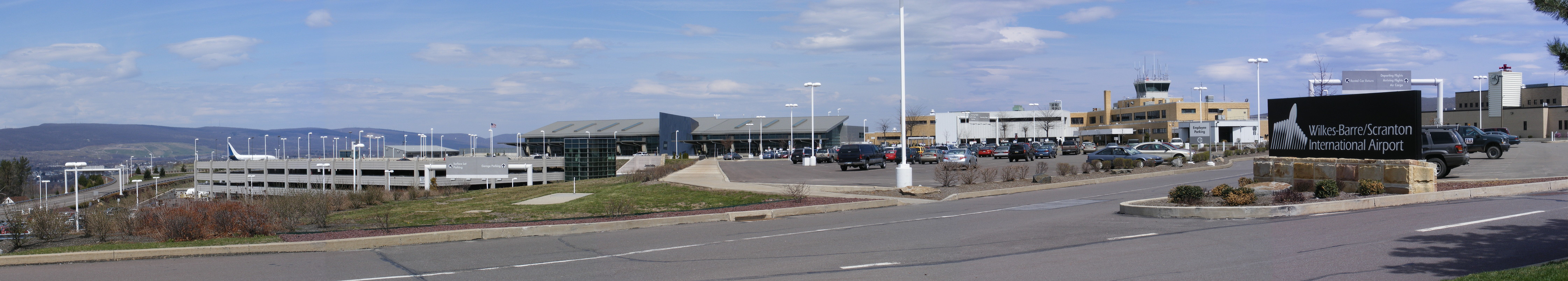
Wilkes-barre/scranton Intl Airport |
| Wilkes-Barre/Scranton International Airport |
 |
 |
| IATA: AVP – ICAO: KAVP – FAA LID: AVP |
| Summary |
| Airport type |
Public |
| Owner |
Luzerne and Lackawanna Counties |
| Serves |
Wilkes-Barre / Scranton |
| Location |
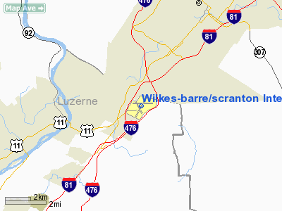
Pittston Township, Pennsylvania |
| Elevation AMSL |
962 ft / 293 m |
| Coordinates |
41°20′18″N 075°43′24″W / 41.33833°N 75.72333°W / 41.33833; -75.72333 |
| Website |
www.FlyAVP.com |
| Runways |
| Direction |
Length |
Surface |
| ft |
m |
| 4/22 |
7,501 |
2,286 |
Asphalt |
| 10/28 |
4,300 |
1,311 |
Asphalt |
| Statistics (2006) |
| Aircraft operations |
78,937 |
| Based aircraft |
30 |
| Source: Federal Aviation Administration |
Wilkes-Barre/Scranton International Airport (IATA: AVP, ICAO: KAVP, FAA LID: AVP) is an airport located in Pittston Township, Pennsylvania, near the border of Luzerne County and Lackawanna County, halfway between the cities of Wilkes-Barre and Scranton.
Five airlines serve the Wilkes-Barre/Scranton International Airport. These airlines are US Airways, United Airlines, Delta Air Lines, Continental Airlines, and American Airlines. Since the spring of 2002, the airport has increased the number of non-stop flights from the airport. Air Force One has landed several times in Avoca for various presidential visits to the Wilkes-Barre/Scranton area. In 1990, the airport was referenced in the film Home Alone when Catherine O'Hara's character Kate McCallister is stuck in the "Scranton airport" during a blizzard. The airport advertises itself as "your gateway to Northeastern Pennsylvania and the Pocono Mountains."
In May 2006, the Wilkes-Barre/Scranton International Airport completed an $80 million construction project on an entirely new terminal and parking garage. The new terminal has many conveniences such as jetways, a bigger waiting area, more gates, and a shopping and dining are.
The airport once offered a flight to Canada; even though this flight no longer exists, the "international" status, granted in 1975, is retained because this airport has a full time U.S. Customs Office. The airport was once home to a Hooters Air non-stop flight to Orlando and it currently hosts seasonal Southwest Airlines non-stop chartered flights to Orlando through Boscov's Travel. Also, in May 2008, Southern Skyways was planning to introduce a non-stop seasonal flight to Myrtle Beach, South Carolina. However, Myrtle Beach Direct Air operated those flights until leaving the airport in August 2008.
The name "Wilkes-Barre/Scranton International Airport" was coined by Congressman Daniel J. Flood of Wilkes-Barre. He had a love of the city, so he said Wilkes-Barre should be first, although Scranton is the larger city, and that Scranton comes first alphabetically.
Recent changes to airport scheduling have included the decision of Continental Airlines to terminate its Cleveland direct service and instead offer service to Newark Liberty, and Delta Airlines' decision to end its direct service to Atlanta. Delta subsequently took over the direct service to Detroit that had been operated by Northwest Airlines, with whom Delta merged. In January 2010 construction started on a new state of the art Airt Traffic Control tower and TRACON Center. The new tower will replace the current aging facility when commissioned somewhere around 2012 Facilities and aircraft
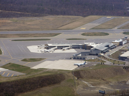 | |
Terminal buildings as seen from the air. |
Wilkes-Barre/Scranton International Airport covers an area of 905 acres (366 ha) which contains two asphalt paved runways:
- 4/22 measuring 7,501 x 150 ft (2,286 x 46 m)
- 10/28 measuring 4,300 x 150 ft (1,311 x 46 m).
For the 12-month period ending December 31, 2006, the airport had 78,937 aircraft operations, an average of 216 per day: 71% general aviation, 28% scheduled commercial, 1% military and <1% air taxi. There are 30 aircraft based at this airport: 60% single engine, 20% multi-engine, 13% jet aircraft and 7% helicopters.
General aviation on the field is serviced by FBO (Fixed Base Operator) Saker Aviation Services, formerly FirstFlight.
Airlines and destinations
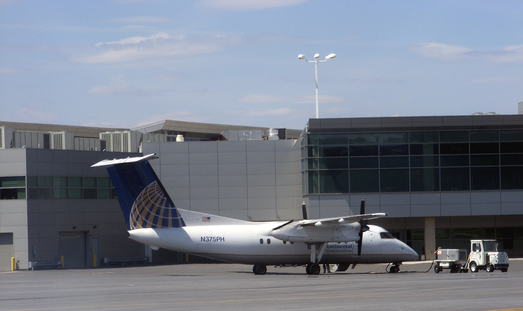
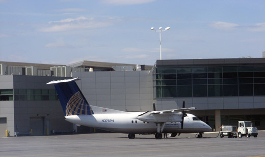 | |
A Continental Connection plane being serviced at the new terminal. |
| Airlines |
Destinations |
| American Eagle |
Chicago-O'Hare |
| Continental Connection operated by CommutAir |
Newark |
| Delta Connection operated by Pinnacle Airlines |
Detroit |
| United Express operated by Expressjet Airlines |
Chicago-O'Hare |
| US Airways Express operated by Air Wisconsin |
Philadelphia |
| US Airways Express operated by Mesa Airlines |
Charlotte [Seasonal] |
| US Airways Express operated by PSA Airlines |
Philadelphia, Charlotte |
| US Airways Express operated by Piedmont Airlines |
Philadelphia |
The above content comes from Wikipedia and is published under free licenses – click here to read more.
 |
(Click on the photo to enlarge) |
Location & QuickFacts
| FAA Information Effective: | 2008-09-25 |
| Airport Identifier: | AVP |
| Airport Status: | Operational |
| Longitude/Latitude: | 075-43-24.2000W/41-20-18.5000N
-75.723389/41.338472 (Estimated) |
| Elevation: | 962 ft / 293.22 m (Surveyed) |
| Land: | 905 acres |
| From nearest city: | 5 nautical miles SW of Wilkes-barre/scranton, PA |
| Location: | Luzerne County, PA |
| Magnetic Variation: | 11W (1980) |
Owner & Manager
| Ownership: | Publicly owned |
| Owner: | Luzerne And Lackawanna Co |
| Address: | 100 Terminal Road
Avoca, PA 18641 |
| Phone number: | 570-602-2030 |
| Manager: | Barry J. Centini |
| Address: | 100 Terminal Road
Avoca, PA 18641 |
| Phone number: | 570-602-2000 |
Airport Operations and Facilities
| Airport Use: | Open to public |
| Wind indicator: | Yes |
| Segmented Circle: | No |
| Control Tower: | Yes |
| Lighting Schedule: | DUSK-DAWN |
| Beacon Color: | Clear-Green (lighted land airport) |
| Landing fee charge: | Yes |
| Sectional chart: | New York |
| Region: | AEA - Eastern |
| Boundary ARTCC: | ZNY - New York |
| Tie-in FSS: | IPT - Williamsport |
| FSS Toll Free: | 1-800-WX-BRIEF |
| NOTAMs Facility: | AVP (NOTAM-d service avaliable) |
| Certification type/date: | I B S 05/1973 |
| Federal Agreements: | NGYH3 |
Airport Communications
Airport Services
| Fuel available: | 100LLA |
| Airframe Repair: | MAJOR |
| Power Plant Repair: | MAJOR |
| Bottled Oxygen: | LOW |
| Bulk Oxygen: | LOW |
Runway Information
Runway 04/22
| Dimension: | 7501 x 150 ft / 2286.3 x 45.7 m |
| Surface: | ASPH, Good Condition |
| Surface Treatment: | Saw-cut or plastic Grooved |
| Pavement Class: | 45 /F/A/X/T |
| Weight Limit: | Single wheel: 133000 lbs.
Dual wheel: 173000 lbs.
Dual tandem wheel: 300000 lbs. |
| Edge Lights: | High |
| |
Runway 04 |
Runway 22 |
| Longitude: | 075-43-53.5083W | 075-43-00.3912W |
| Latitude: | 41-19-43.3132N | 41-20-45.6731N |
| Elevation: | 962.00 ft | 911.00 ft |
| Alignment: | 32 | 127 |
| ILS Type: | ILS/DME
| ILS/DME
|
| Traffic Pattern: | Left | Right |
| Markings: | Precision instrument, Good Condition | Precision instrument, Good Condition |
| Crossing Height: | 65.00 ft | 54.00 ft |
| VASI: | 4-light PAPI on right side | 4-box on left side |
| Visual Glide Angle: | 3.00° | 3.00° |
| RVR Equipment: | touchdown | |
| Approach lights: | MALSR | |
| Runway End Identifier: | | Yes |
| Obstruction: | , 50:1 slope to clear | 87 ft tower, 4103.0 ft from runway, 396 ft right of centerline, 45:1 slope to clear |
|
Runway 10/28
| Dimension: | 4300 x 150 ft / 1310.6 x 45.7 m |
| Surface: | ASPH, Good Condition |
| Surface Treatment: | Saw-cut or plastic Grooved |
| Weight Limit: | Single wheel: 58000 lbs.
Dual wheel: 80000 lbs.
Dual tandem wheel: 125000 lbs. |
| Edge Lights: | Medium |
| |
Runway 10 |
Runway 28 |
| Longitude: | 075-43-47.6600W | 075-42-51.3141W |
| Latitude: | 41-20-26.1633N | 41-20-24.8861N |
| Elevation: | 922.00 ft | 934.00 ft |
| Alignment: | 91 | 127 |
| Traffic Pattern: | Right | Right |
| Markings: | Non-precision instrument, Good Condition | Non-precision instrument, Good Condition |
| Runway End Identifier: | Yes | Yes |
| Obstruction: | , 50:1 slope to clear | 48 ft trees, 800.0 ft from runway, 170 ft right of centerline, 13:1 slope to clear |
|
Radio Navigation Aids
| ID |
Type |
Name |
Ch |
Freq |
Var |
Dist |
| CYE | NDB | Crystal Lake | | 410.00 | 11W | 9.1 nm |
| HXM | NDB | Humbolt | | 366.00 | 10W | 24.4 nm |
| LQX | NDB | Carbon | | 339.00 | 12W | 31.7 nm |
| PIX | NDB | Picture Rocks | | 344.00 | 09W | 44.7 nm |
| MS | NDB | Monga | | 359.00 | 12W | 46.6 nm |
| HZL | VOR | Hazleton | | 109.40 | 09W | 28.4 nm |
| STW | VOR/DME | Stillwater | 033X | 109.60 | 11W | 43.8 nm |
| ETX | VOR/DME | East Texas | 039X | 110.20 | 09W | 45.6 nm |
| HNK | VOR/DME | Hancock | 115X | 116.80 | 11W | 47.2 nm |
| FQM | VOR/DME | Williamsport | 091X | 114.40 | 09W | 47.5 nm |
| LVZ | VORTAC | Wilkes-barre | 053X | 111.60 | 10W | 4.2 nm |
| LHY | VORTAC | Lake Henry | 045X | 110.80 | 10W | 13.6 nm |
| FJC | VORTAC | Allentown | 122X | 117.50 | 10W | 38.7 nm |
| MIP | VORTAC | Milton | 029X | 109.20 | 09W | 46.6 nm |
Remarks
- RY 10 CLSD FOR LANDINGS.
- FIRST 1,150 FT RY 10 NOT VISIBLE FROM ATCT.
- ENGINEERED MATERIALS ARRESTING SYSTEM (EMAS) 170 FT WIDTH 324 FT IN LENGTH LCTD 50 FT OFF DEP END RY 04.
- DEER & BIRDS ON & INVOF ARPT.
- RY 28 UNLGTD HIGH TERRAIN TREES: 1155 FT MSL .91 MI EAST AER 28; 1463 FT MSL 1.49 MI EAST-SOUTHEAST AER 28; 1667 FT MSL 2.25 MI EAST AER 28; 1920 FT MSL 2.84 MI EAST AER 28.
- UNLGTD TOWER 1130 FT MSL (20 FT AGL) 1.3 MI EAST AER 28; UNLGTD TOWER 1463 FT MSL (20 FT AGL) 1.7 MI EAST AER 28; UNLGTD TOWER 1652 FT MSL (20 FT AGL) 2.4 MI EAST AER 28.
- WESTERN 1/3 OF TWY D NOT VISIBLE FROM ATCT
- TWY E NOT VISIBLE FROM ATCT
- EXISTED PRIOR TO REQMT FOR AIRSPACE DETER.
Images and information placed above are from
http://www.airport-data.com/airport/AVP/
We thank them for the data!
| General Info
|
| Country |
United States
|
| State |
PENNSYLVANIA
|
| FAA ID |
AVP
|
| Latitude |
41-20-17.338N
|
| Longitude |
075-43-27.363W
|
| Elevation |
962 feet
|
| Near City |
WILKES-BARRE/SCRANTON
|
We don't guarantee the information is fresh and accurate. The data may
be wrong or outdated.
For more up-to-date information please refer to other sources.
|
|