 |
|
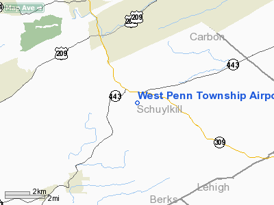
West Penn Township Airport |
Location & QuickFacts
| FAA Information Effective: | 2008-09-25 |
| Airport Identifier: | PS99 |
| Airport Status: | Operational |
| Longitude/Latitude: | 075-55-58.7270W/40-44-52.3280N
-75.932980/40.747869 (Estimated) |
| Elevation: | 1200 ft / 365.76 m (Estimated) |
| Land: | 6 acres |
| From nearest city: | 4 nautical miles SE of Tamaqua, PA |
| Location: | Schuylkill County, PA |
| Magnetic Variation: | 11W (1985) |
Owner & Manager
| Ownership: | Privately owned |
| Owner: | Michael John Savlik |
| Address: | Rd 1, Box 111
New Ringgold, PA 17960 |
| Phone number: | 717-386-4923 |
| Address: |
|
Airport Operations and Facilities
| Airport Use: | Private |
| Wind indicator: | Yes |
| Segmented Circle: | No |
| Control Tower: | No |
| Landing fee charge: | No |
| Sectional chart: | New York |
| Region: | AEA - Eastern |
| Boundary ARTCC: | ZNY - New York |
| Tie-in FSS: | IPT - Williamsport |
| FSS on Airport: | No |
| FSS Toll Free: | 1-800-WX-BRIEF |
Runway Information
Runway 09/27
| Dimension: | 2000 x 100 ft / 609.6 x 30.5 m |
| Surface: | TURF, |
| |
Runway 09 |
Runway 27 |
| Traffic Pattern: | Left | Left |
| Displaced threshold: | 500.00 ft | 300.00 ft |
|
Radio Navigation Aids
| ID |
Type |
Name |
Ch |
Freq |
Var |
Dist |
| LQX | NDB | Carbon | | 339.00 | 12W | 8.8 nm |
| HXM | NDB | Humbolt | | 366.00 | 10W | 14.8 nm |
| CYE | NDB | Crystal Lake | | 410.00 | 11W | 28.2 nm |
| BZJ | NDB | Bellgrove | | 328.00 | 10W | 33.9 nm |
| UKT | NDB | Quakertown | | 208.00 | 12W | 34.9 nm |
| DYL | NDB | Doylestown | | 237.00 | 10W | 44.6 nm |
| PIX | NDB | Picture Rocks | | 344.00 | 09W | 47.5 nm |
| ING | NDB | Ambler | | 275.00 | 11W | 47.7 nm |
| NXX | NDB | Willow Grove | | 388.00 | 12W | 49.2 nm |
| NXX | TACAN | Willow Grove | 061X | | 10W | 49.0 nm |
| HZL | VOR | Hazleton | | 109.40 | 09W | 16.2 nm |
| ETX | VOR/DME | East Texas | 039X | 110.20 | 09W | 15.2 nm |
| CKZ | VOR/DME | Pennridge | 025Y | 108.85 | 12W | 36.4 nm |
| FJC | VORTAC | Allentown | 122X | 117.50 | 10W | 21.8 nm |
| RAV | VORTAC | Ravine | 093X | 114.60 | 11W | 32.6 nm |
| LVZ | VORTAC | Wilkes-barre | 053X | 111.60 | 10W | 33.4 nm |
| PTW | VORTAC | Pottstown | 112X | 116.50 | 09W | 35.9 nm |
| MIP | VORTAC | Milton | 029X | 109.20 | 09W | 37.2 nm |
| LRP | VORTAC | Lancaster | 120X | 117.30 | 09W | 41.1 nm |
| SEG | VORTAC | Selinsgrove | 041X | 110.40 | 08W | 43.4 nm |
| LHY | VORTAC | Lake Henry | 045X | 110.80 | 10W | 48.3 nm |
Images and information placed above are from
http://www.airport-data.com/airport/PS99/
We thank them for the data!
| General Info
|
| Country |
United States
|
| State |
PENNSYLVANIA
|
| FAA ID |
PS99
|
| Latitude |
40-44-52.328N
|
| Longitude |
075-55-58.727W
|
| Elevation |
1200 feet
|
| Near City |
TAMAQUA
|
We don't guarantee the information is fresh and accurate. The data may
be wrong or outdated.
For more up-to-date information please refer to other sources.
|
|


