|
|
Van Sant Airport
(Vansant Airport) |
 |
| IATA: none – ICAO: none – FAA LID: 9N1 |
| Summary |
| Airport type |
Public |
| Owner/Operator |
Bucks County Airport Authority |
| Location |
Erwinna, Pennsylvania |
| Elevation AMSL |
390 ft / 119 m |
| Coordinates |
40°29′03″N 075°05′59″W / 40.48417°N 75.09972°W / 40.48417; -75.09972 |
| Website |
www.bcaanet.org/... |
| Runways |
| Direction |
Length |
Surface |
| ft |
m |
| 5G/23G |
1,340 |
408 |
Turf |
| 7/25 |
3,058 |
932 |
Turf |
| Statistics (2008) |
| Aircraft operations |
25,695 |
| Based aircraft |
53 |
| Source: Federal Aviation Administration |
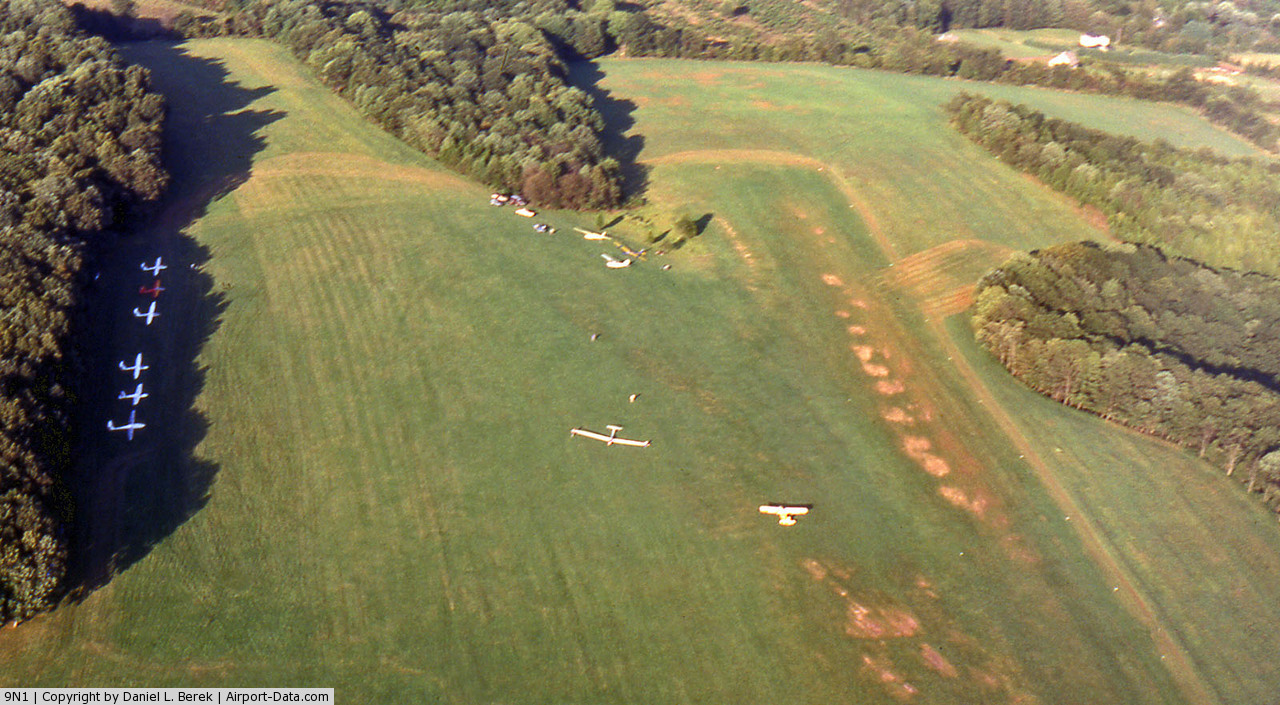
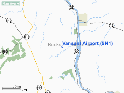
Vansant Airport or Van Sant Airport (FAA LID: 9N1) is a public use airport located in Bucks County, Pennsylvania, United States and owned by the Bucks County Airport Authority. It is two nautical miles (3.7 km) southwest of the central business district of Erwinna, Pennsylvania. History
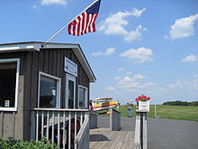
In 1944, John Van Sant (born 1912) bought the Silver Star Airport, renamed it to The Old Star Airport, and started his own business, Van Sant Flying Service. The business offered crop dusting and flight training. Since then the airport was sold then resold to the Bucks County park system. Now the airport is a landmark for Classic Biplane rides and vintage airplanes.
After World War II, John Van Sant founded and owned Van Sant Airport. His family sold it to Bucks County in 2003, and it was designated as a National Historic Landmark. The 198.5 acre (0.8 km²) piece of property was sold to the county for almost US$3 million. The Bucks County Airport Authority currently maintains the airport, and facilities on the field are leased to Sport Aviation, Inc, a fixed base operator (FBO).
Facilities and aircraft
The airport covers an area of 167 acres (68 ha) at an elevation of 390 feet (119 m) above mean sea level. It has two runways with turf surfaces:: 7/25 is 3,058 by 120 feet (932 x 37 m) and 5G/23G is 1,340 by 200 feet (408 x 61 m).
For the 12-month period ending June 17, 2008, the airport had 25,695 aircraft operations, an average of 70 per day: 100% general aviation and <1% military. At that time there were 53 aircraft based at this airport: 75% single-engine, 23% glider and 2% ultralight.
The above content comes from Wikipedia and is published under free licenses – click here to read more.
 |
(Click on the photo to enlarge) |
Location & QuickFacts
| FAA Information Effective: | 2008-09-25 |
| Airport Identifier: | 9N1 |
| Airport Status: | Operational |
| Longitude/Latitude: | 075-05-58.6180W/40-29-03.3710N
-75.099616/40.484270 (Estimated) |
| Elevation: | 390 ft / 118.87 m (Estimated) |
| Land: | 167 acres |
| From nearest city: | 2 nautical miles SW of Erwinna, PA |
| Location: | Bucks County, PA |
| Magnetic Variation: | 12W (1985) |
Owner & Manager
| Ownership: | Publicly owned |
| Owner: | Bucks County Airport Authority |
| Address: | P.o. Box 1185, 3879 Old Easton Road
Doylestown, PA 18901 |
| Phone number: | 215-345-1970 |
| Manager: | Azhar Husain |
| Address: | 516 Cafferty Rd Po Box 176
Erwinna, PA 18920 |
| Phone number: | 610-847-8320 |
Airport Operations and Facilities
| Airport Use: | Open to public |
| Wind indicator: | Yes |
| Segmented Circle: | No |
| Control Tower: | No |
| Landing fee charge: | No |
| Sectional chart: | New York |
| Region: | AEA - Eastern |
| Traffic Pattern Alt: | 800 ft |
| Boundary ARTCC: | ZNY - New York |
| Tie-in FSS: | IPT - Williamsport |
| FSS on Airport: | No |
| FSS Toll Free: | 1-800-WX-BRIEF |
| NOTAMs Facility: | IPT (NOTAM-d service avaliable) |
Airport Communications
| CTAF: | 122.800 |
| Unicom: | 122.800 |
Airport Services
| Fuel available: | 100LL |
| Airframe Repair: | MAJOR |
| Power Plant Repair: | MAJOR |
| Bottled Oxygen: | NONE |
| Bulk Oxygen: | NONE |
Runway Information
Runway 05G/23G
| Dimension: | 1340 x 200 ft / 408.4 x 61.0 m |
| Surface: | TURF, Good Condition |
| |
Runway 05G |
Runway 23G |
| Traffic Pattern: | Left | Left |
| Obstruction: | , 50:1 slope to clear | 43 ft trees, 286.0 ft from runway, 152 ft left of centerline, 6:1 slope to clear |
|
Runway 07/25
| Dimension: | 3058 x 120 ft / 932.1 x 36.6 m |
| Surface: | TURF, Good Condition |
| |
Runway 07 |
Runway 25 |
| Traffic Pattern: | Left | Left |
| Displaced threshold: | 365.00 ft | 0.00 ft |
| Obstruction: | 15 ft road, 43.0 ft from runway, 11 ft right of centerline, 2:1 slope to clear
APCH RATIO 27:1 TO DSPLCD THLD. | 25 ft trees, 659.0 ft from runway, 34 ft right of centerline, 26:1 slope to clear |
|
Radio Navigation Aids
| ID |
Type |
Name |
Ch |
Freq |
Var |
Dist |
| EWR | FAN MARKER | Maryann | | | 11W | 43.7 nm |
| DYL | NDB | Doylestown | | 237.00 | 10W | 9.0 nm |
| UKT | NDB | Quakertown | | 208.00 | 12W | 9.7 nm |
| NXX | NDB | Willow Grove | | 388.00 | 12W | 17.9 nm |
| ING | NDB | Ambler | | 275.00 | 11W | 23.2 nm |
| CAT | NDB | Chatham | | 254.00 | 11W | 34.2 nm |
| LQX | NDB | Carbon | | 339.00 | 12W | 36.0 nm |
| NEL | NDB | Lakehurst | | 396.00 | 13W | 43.9 nm |
| NXX | TACAN | Willow Grove | 061X | | 10W | 17.5 nm |
| NEL | TACAN | Lakehurst | 055X | | 11W | 43.5 nm |
| NEL | UHF/NDB | Lakehurst | | 274.80 | 13W | 43.9 nm |
| PNE | VOR | North Philadelphia | | 112.00 | 10W | 24.5 nm |
| CKZ | VOR/DME | Pennridge | 025Y | 108.85 | 12W | 10.3 nm |
| ARD | VOR/DME | Yardley | 019X | 108.20 | 10W | 16.4 nm |
| SBJ | VOR/DME | Solberg | 076X | 112.90 | 10W | 17.4 nm |
| BWZ | VOR/DME | Broadway | 089X | 114.20 | 11W | 22.7 nm |
| ETX | VOR/DME | East Texas | 039X | 110.20 | 09W | 27.3 nm |
| STW | VOR/DME | Stillwater | 033X | 109.60 | 11W | 32.5 nm |
| COL | VOR/DME | Colts Neck | 101X | 115.40 | 11W | 44.3 nm |
| FJC | VORTAC | Allentown | 122X | 117.50 | 10W | 21.8 nm |
| PTW | VORTAC | Pottstown | 112X | 116.50 | 09W | 26.3 nm |
| RBV | VORTAC | Robbinsville | 085X | 113.80 | 10W | 32.5 nm |
| GXU | VORTAC | Mc Guire | 043X | 110.60 | 11W | 36.7 nm |
| MXE | VORTAC | Modena | 079X | 113.20 | 09W | 43.0 nm |
| SAX | VORTAC | Sparta | 104X | 115.70 | 11W | 43.4 nm |
| PHL | VOT | Philadelphia Intl | | 109.80 | | 37.5 nm |
Remarks
- HEAVY GLIDER TFC.
- ARPT CLSD TO TRANSIENT TRAFFIC DEC THRU APR.
- GLIDERS OCNLLY USE POWER PLANE RWY FOR LNDG TO THE WEST.
- RWY 23 GLIDERS ONLY.
- RWY 05 LANDINGS AND TAKEOFFS PROHIBITED.
- VFR USE ONLY
Images and information placed above are from
http://www.airport-data.com/airport/9N1/
We thank them for the data!
| General Info
|
| Country |
United States
|
| State |
PENNSYLVANIA
|
| FAA ID |
9N1
|
| Latitude |
40-29-03.371N
|
| Longitude |
075-05-58.618W
|
| Elevation |
390 feet
|
| Near City |
ERWINNA
|
We don't guarantee the information is fresh and accurate. The data may
be wrong or outdated.
For more up-to-date information please refer to other sources.
|
|