 |
|
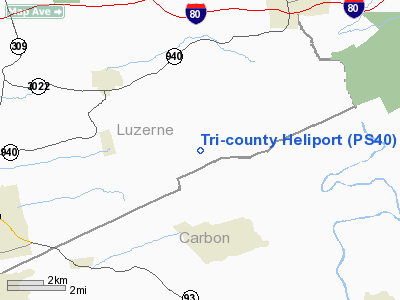
Location & QuickFacts
| FAA Information Effective: | 2008-09-25 |
| Airport Identifier: | PS40 |
| Airport Status: | Operational |
| Longitude/Latitude: | 075-50-03.7050W/40-59-10.3060N
-75.834362/40.986196 (Estimated) |
| Elevation: | 1700 ft / 518.16 m (Estimated) |
| Land: | 0 acres |
| From nearest city: | 2 nautical miles SE of Eckley, PA |
| Location: | Luzerne County, PA |
| Magnetic Variation: | 08W (1985) |
Owner & Manager
| Ownership: | Privately owned |
| Owner: | Tri-county Sanitation Co |
| Address: |
|
| Phone number: | 717-427-4500 |
| Manager: | Randy Freeman |
| Address: | 1963 Pen Argyl Road
Pen Argyl, PA 18072 |
| Phone number: | 610-863-6057 |
Airport Operations and Facilities
| Airport Use: | Private |
| Wind indicator: | Yes |
| Segmented Circle: | No |
| Control Tower: | No |
| Sectional chart: | New York |
| Region: | AEA - Eastern |
| Boundary ARTCC: | ZNY - New York |
| Tie-in FSS: | IPT - Williamsport |
| FSS Toll Free: | 1-800-WX-BRIEF |
Runway Information
Helipad H1
| Dimension: | 55 x 55 ft / 16.8 x 16.8 m |
| Surface: | ASPH-CONC, |
| |
Runway H1 |
Runway |
| Traffic Pattern: | Left | Left |
|
Radio Navigation Aids
| ID |
Type |
Name |
Ch |
Freq |
Var |
Dist |
| HXM | NDB | Humbolt | | 366.00 | 10W | 7.4 nm |
| LQX | NDB | Carbon | | 339.00 | 12W | 11.0 nm |
| CYE | NDB | Crystal Lake | | 410.00 | 11W | 13.5 nm |
| UKT | NDB | Quakertown | | 208.00 | 12W | 41.7 nm |
| PIX | NDB | Picture Rocks | | 344.00 | 09W | 43.3 nm |
| BZJ | NDB | Bellgrove | | 328.00 | 10W | 46.5 nm |
| HZL | VOR | Hazleton | | 109.40 | 09W | 13.2 nm |
| ETX | VOR/DME | East Texas | 039X | 110.20 | 09W | 25.3 nm |
| CKZ | VOR/DME | Pennridge | 025Y | 108.85 | 12W | 43.6 nm |
| STW | VOR/DME | Stillwater | 033X | 109.60 | 11W | 43.8 nm |
| BWZ | VOR/DME | Broadway | 089X | 114.20 | 11W | 47.4 nm |
| FQM | VOR/DME | Williamsport | 091X | 114.40 | 09W | 47.5 nm |
| LVZ | VORTAC | Wilkes-barre | 053X | 111.60 | 10W | 18.4 nm |
| FJC | VORTAC | Allentown | 122X | 117.50 | 10W | 23.3 nm |
| LHY | VORTAC | Lake Henry | 045X | 110.80 | 10W | 33.4 nm |
| MIP | VORTAC | Milton | 029X | 109.20 | 09W | 37.8 nm |
| RAV | VORTAC | Ravine | 093X | 114.60 | 11W | 43.5 nm |
| PTW | VORTAC | Pottstown | 112X | 116.50 | 09W | 47.6 nm |
| SEG | VORTAC | Selinsgrove | 041X | 110.40 | 08W | 49.1 nm |
Remarks
- LMTD SK-26 OR BELL 212 OR SMALLER; APP/DEP LMTD TO 700 FEET AGL IN AREA OF CONTROLLED AIRSPACE SURROUNDING HAZELTON APT.
Images and information placed above are from
http://www.airport-data.com/airport/PS40/
We thank them for the data!
| General Info
|
| Country |
United States
|
| State |
PENNSYLVANIA
|
| FAA ID |
PS40
|
| Latitude |
40-59-10.306N
|
| Longitude |
075-50-03.705W
|
| Elevation |
1700 feet
|
| Near City |
ECKLEY
|
We don't guarantee the information is fresh and accurate. The data may
be wrong or outdated.
For more up-to-date information please refer to other sources.
|
|


