 |
|
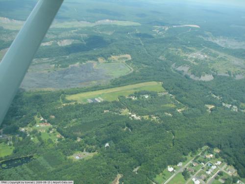 |
(Click on the photo to enlarge) |
Location & QuickFacts
| FAA Information Effective: | 2008-09-25 |
| Airport Identifier: | 7PN0 |
| Airport Status: | Operational |
| Longitude/Latitude: | 076-14-11.0000W/40-42-18.0000N
-76.236389/40.705000 (Estimated) |
| Elevation: | 930 ft / 283.46 m (Estimated) |
| Land: | 32 acres |
| From nearest city: | 1 nautical miles NE of Minersville, PA |
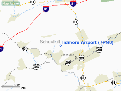
| Location: | Schuylkill County, PA |
| Magnetic Variation: | 11W (1985) |
Owner & Manager
| Ownership: | Privately owned |
| Owner: | Argie D. Tidmore |
| Address: | Po Box 86
Pottsville, PA 17901 |
| Phone number: | 570-622-1360
X26. |
| Manager: | Argie D. Tidmore |
| Address: | Po Box 86
Pottsville, PA 17901 |
| Phone number: | 570-622-1360 |
Airport Operations and Facilities
| Airport Use: | Private |
| Wind indicator: | Yes |
| Segmented Circle: | No |
| Control Tower: | No |
| Landing fee charge: | No |
| Sectional chart: | New York |
| Region: | AEA - Eastern |
| Traffic Pattern Alt: | 800 ft |
| Boundary ARTCC: | ZNY - New York |
| Tie-in FSS: | IPT - Williamsport |
| FSS on Airport: | No |
| FSS Toll Free: | 1-800-WX-BRIEF |
Airport Services
| Bottled Oxygen: | NONE |
| Bulk Oxygen: | NONE |
Runway Information
Runway 08/26
| Dimension: | 2000 x 150 ft / 609.6 x 45.7 m |
| Surface: | TURF, Good Condition |
| |
Runway 08 |
Runway 26 |
| Traffic Pattern: | Left | Left |
| Runway End Identifier: | No | No |
| Obstruction: | 33 ft tree, 492.0 ft from runway | 18 ft trees, 271.0 ft from runway |
|
Radio Navigation Aids
| ID |
Type |
Name |
Ch |
Freq |
Var |
Dist |
| HXM | NDB | Humbolt | | 366.00 | 10W | 20.2 nm |
| BZJ | NDB | Bellgrove | | 328.00 | 10W | 21.7 nm |
| LQX | NDB | Carbon | | 339.00 | 12W | 22.7 nm |
| CYE | NDB | Crystal Lake | | 410.00 | 11W | 35.5 nm |
| PIX | NDB | Picture Rocks | | 344.00 | 09W | 40.5 nm |
| UKT | NDB | Quakertown | | 208.00 | 12W | 46.1 nm |
| HZL | VOR | Hazleton | | 109.40 | 09W | 17.0 nm |
| ETX | VOR/DME | East Texas | 039X | 110.20 | 09W | 26.3 nm |
| FQM | VOR/DME | Williamsport | 091X | 114.40 | 09W | 45.2 nm |
| CKZ | VOR/DME | Pennridge | 025Y | 108.85 | 12W | 47.2 nm |
| RAV | VORTAC | Ravine | 093X | 114.60 | 11W | 18.9 nm |
| MIP | VORTAC | Milton | 029X | 109.20 | 09W | 27.3 nm |
| SEG | VORTAC | Selinsgrove | 041X | 110.40 | 08W | 29.9 nm |
| LRP | VORTAC | Lancaster | 120X | 117.30 | 09W | 35.3 nm |
| FJC | VORTAC | Allentown | 122X | 117.50 | 10W | 35.6 nm |
| LVZ | VORTAC | Wilkes-barre | 053X | 111.60 | 10W | 42.2 nm |
| PTW | VORTAC | Pottstown | 112X | 116.50 | 09W | 42.4 nm |
| HAR | VORTAC | Harrisburg | 072X | 112.50 | 10W | 45.1 nm |
| MDT | VOT | Harrisburg International | | 110.00 | | 38.9 nm |
Remarks
Images and information placed above are from
http://www.airport-data.com/airport/7PN0/
We thank them for the data!
| General Info
|
| Country |
United States
|
| State |
PENNSYLVANIA
|
| FAA ID |
7PN0
|
| Latitude |
40-42-18.000N
|
| Longitude |
076-14-11.000W
|
| Elevation |
930 feet
|
| Near City |
MINERSVILLE
|
We don't guarantee the information is fresh and accurate. The data may
be wrong or outdated.
For more up-to-date information please refer to other sources.
|
|


