 |
|
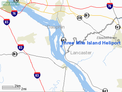
Three Mile Island Heliport |
Location & QuickFacts
| FAA Information Effective: | 2008-09-25 |
| Airport Identifier: | PS14 |
| Airport Status: | Operational |
| Longitude/Latitude: | 076-43-23.8860W/40-08-38.3360N
-76.723302/40.143982 (Estimated) |
| Elevation: | 310 ft / 94.49 m (Estimated) |
| Land: | 0 acres |
| From nearest city: | 3 nautical miles SE of Middletown, PA |
| Location: | Dauphin County, PA |
| Magnetic Variation: | 10W (1985) |
Owner & Manager
| Ownership: | Privately owned |
| Owner: | Amergen Three Mile Island Unit 1 |
| Address: | Route 441 South, Po Box 480
Middletown, PA 17057 |
| Phone number: | 717-944-7621 |
| Manager: | Amergen Three Mile Island Unit 1 |
| Address: | Route 441 South, Po Box 480
Middletown, PA 17051 |
| Phone number: | 717-944-7621 |
Airport Operations and Facilities
| Airport Use: | Private |
| Wind indicator: | Yes |
| Segmented Circle: | No |
| Control Tower: | No |
| Lighting Schedule: | PHONE REQ
FOR PERIMETER LGTS CALL 717-948-8000. |
| Landing fee charge: | No |
| Sectional chart: | New York |
| Region: | AEA - Eastern |
| Boundary ARTCC: | ZNY - New York |
| Tie-in FSS: | IPT - Williamsport |
| FSS on Airport: | No |
| FSS Toll Free: | 1-800-WX-BRIEF |
Runway Information
Helipad H1
| Dimension: | 175 x 65 ft / 53.3 x 19.8 m |
| Surface: | GRAVEL, |
| |
Runway H1 |
Runway |
| Traffic Pattern: | Left | Left |
|
Radio Navigation Aids
| ID |
Type |
Name |
Ch |
Freq |
Var |
Dist |
| EUD | NDB | York | | 254.00 | 11W | 15.2 nm |
| BZJ | NDB | Bellgrove | | 328.00 | 10W | 19.2 nm |
| APG | NDB | Aberdeen | | 349.00 | 11W | 46.4 nm |
| PPM | VOR/DME | Phillips | 021X | 108.40 | 09W | 48.0 nm |
| HAR | VORTAC | Harrisburg | 072X | 112.50 | 10W | 18.5 nm |
| LRP | VORTAC | Lancaster | 120X | 117.30 | 09W | 19.9 nm |
| RAV | VORTAC | Ravine | 093X | 114.60 | 11W | 25.3 nm |
| SEG | VORTAC | Selinsgrove | 041X | 110.40 | 08W | 39.6 nm |
| EMI | VORTAC | Westminster | 126X | 117.90 | 08W | 40.7 nm |
| MDT | VOT | Harrisburg International | | 110.00 | | 3.7 nm |
Remarks
- E111: PRVDD MARKING SPHERES ARE INSTALLED ON THE TRANSMISSION LINE SOUTH OF HELI.
Images and information placed above are from
http://www.airport-data.com/airport/PS14/
We thank them for the data!
| General Info
|
| Country |
United States
|
| State |
PENNSYLVANIA
|
| FAA ID |
PS14
|
| Latitude |
40-08-38.336N
|
| Longitude |
076-43-23.886W
|
| Elevation |
310 feet
|
| Near City |
MIDDLETOWN
|
We don't guarantee the information is fresh and accurate. The data may
be wrong or outdated.
For more up-to-date information please refer to other sources.
|
|


