 |
|
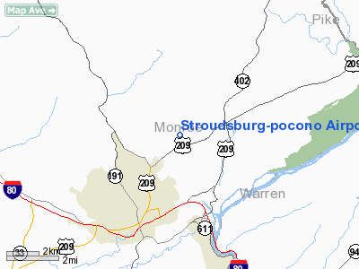
Stroudsburg-pocono Airport |
Location & QuickFacts
| FAA Information Effective: | 2008-09-25 |
| Airport Identifier: | N53 |
| Airport Status: | Operational |
| Longitude/Latitude: | 075-09-38.4440W/41-02-09.1380N
-75.160679/41.035872 (Estimated) |
| Elevation: | 480 ft / 146.30 m (Estimated) |
| Land: | 69 acres |
| From nearest city: | 3 nautical miles N of East Stroudsburg, PA |
| Location: | Monroe County, PA |
| Magnetic Variation: | 11W (1980) |
Owner & Manager
| Ownership: | Privately owned |
| Owner: | Pocono Stroudsburg Airport Inc |
| Address: | 408 Airport Road
East Stroudsburg, PA 18301 |
| Phone number: | 540-980-3550
FAX 540-980-8012 |
| Manager: | Robt Strenz |
| Address: | 408 Airport Road
East Stroudsburg, PA 18301 |
| Phone number: | 540-980-3550
CELL 239-289-6703 |
Airport Operations and Facilities
| Airport Use: | Open to public |
| Wind indicator: | Yes |
| Segmented Circle: | Yes |
| Control Tower: | No |
| Lighting Schedule: | RDO-CTL
ACTVT LIRL RY 08/26 & ROTG BCN - CTAF. |
| Beacon Color: | Clear-Green (lighted land airport) |
| Landing fee charge: | No |
| Sectional chart: | New York |
| Region: | AEA - Eastern |
| Traffic Pattern Alt: | 800 ft |
| Boundary ARTCC: | ZNY - New York |
| Tie-in FSS: | IPT - Williamsport |
| FSS on Airport: | No |
| FSS Toll Free: | 1-800-WX-BRIEF |
| NOTAMs Facility: | IPT (NOTAM-d service avaliable) |
| Federal Agreements: | N |
Airport Communications
| CTAF: | 123.000 |
| Unicom: | 123.000 |
Airport Services
| Fuel available: | 100LL |
| Airframe Repair: | MAJOR |
| Power Plant Repair: | MAJOR |
| Bottled Oxygen: | NONE |
| Bulk Oxygen: | NONE |
Runway Information
Runway 08/26
| Dimension: | 3087 x 30 ft / 940.9 x 9.1 m |
| Surface: | ASPH, Poor Condition
RY ALLEGATOR CRACKING IN PAVEMENT, SPALLING, HEAVING. |
| Edge Lights: | Non-standard lighting system
RY 08/26 NSTD LIRL DUE TO PLACEMENT AND COLOR. |
| |
Runway 08 |
Runway 26 |
| Longitude: | 075-09-56.8650W | 075-09-19.9300W |
| Latitude: | 41-02-03.0950N | 41-02-15.2680N |
| Elevation: | 471.00 ft | 480.00 ft |
| Alignment: | 66 | 127 |
| Traffic Pattern: | Left | Left |
| Markings: | Basic, Fair Condition | Non-precision instrument, Fair Condition |
| Displaced threshold: | 100.00 ft | 770.00 ft |
| Obstruction: | 14 ft brush, 358.0 ft from runway, 31 ft right of centerline, 11:1 slope to clear
RY 08 APCH RATIO 32:1 BASED ON DSPLCD THLD.
BRUSH 13 FT HIGH 74 FT FM THLD 123 FT LEFT. | 26 ft trees, 270.0 ft from runway, 72 ft right of centerline, 2:1 slope to clear
RY 26 APCH RATIO 37:1 TO DSPLCD THLD.
+15 FT ROAD 90 FT FROM THLD EXTENDING ACROSS SAFETY ZONE. |
|
Radio Navigation Aids
| ID |
Type |
Name |
Ch |
Freq |
Var |
Dist |
| EWR | FAN MARKER | Maryann | | | 11W | 48.6 nm |
| LQX | NDB | Carbon | | 339.00 | 12W | 30.3 nm |
| CYE | NDB | Crystal Lake | | 410.00 | 11W | 32.1 nm |
| UKT | NDB | Quakertown | | 208.00 | 12W | 37.3 nm |
| CAT | NDB | Chatham | | 254.00 | 11W | 37.6 nm |
| HXM | NDB | Humbolt | | 366.00 | 10W | 38.0 nm |
| DYL | NDB | Doylestown | | 237.00 | 10W | 42.1 nm |
| MS | NDB | Monga | | 359.00 | 12W | 46.0 nm |
| PNJ | NDB | Paterson | | 347.00 | 12W | 46.1 nm |
| HZL | VOR | Hazleton | | 109.40 | 09W | 43.9 nm |
| STW | VOR/DME | Stillwater | 033X | 109.60 | 11W | 13.4 nm |
| BWZ | VOR/DME | Broadway | 089X | 114.20 | 11W | 21.0 nm |
| SBJ | VOR/DME | Solberg | 076X | 112.90 | 10W | 33.2 nm |
| HUO | VOR/DME | Huguenot | 108X | 116.10 | 11W | 34.2 nm |
| ETX | VOR/DME | East Texas | 039X | 110.20 | 09W | 36.3 nm |
| CKZ | VOR/DME | Pennridge | 025Y | 108.85 | 12W | 39.2 nm |
| ARD | VOR/DME | Yardley | 019X | 108.20 | 10W | 48.4 nm |
| FJC | VORTAC | Allentown | 122X | 117.50 | 10W | 22.9 nm |
| LVZ | VORTAC | Wilkes-barre | 053X | 111.60 | 10W | 27.8 nm |
| SAX | VORTAC | Sparta | 104X | 115.70 | 11W | 28.3 nm |
| LHY | VORTAC | Lake Henry | 045X | 110.80 | 10W | 30.2 nm |
Remarks
- ULTRALIGHTS ON & INVOF ARPT.
- DEER ON & INVOF ARPT.
- EXISTED PRIOR TO 1959.
Images and information placed above are from
http://www.airport-data.com/airport/N53/
We thank them for the data!
| General Info
|
| Country |
United States
|
| State |
PENNSYLVANIA
|
| FAA ID |
N53
|
| Latitude |
41-02-09.138N
|
| Longitude |
075-09-38.444W
|
| Elevation |
480 feet
|
| Near City |
EAST STROUDSBURG
|
We don't guarantee the information is fresh and accurate. The data may
be wrong or outdated.
For more up-to-date information please refer to other sources.
|
|


