 |
|
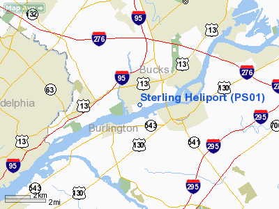
Location & QuickFacts
| FAA Information Effective: | 2008-09-25 |
| Airport Identifier: | PS01 |
| Airport Status: | Operational |
| Longitude/Latitude: | 074-53-39.2000W/40-04-52.6000N
-74.894222/40.081278 (Estimated) |
| Elevation: | 24 ft / 7.32 m (Estimated) |
| Land: | 13 acres |
| From nearest city: | 1 nautical miles SE of Croydon, PA |
| Location: | Bucks County, PA |
| Magnetic Variation: | () |
Owner & Manager
| Ownership: | Privately owned |
| Owner: | Sterling Helicopter |
| Address: | 1226 River Road
Croydon, PA 19021 |
| Phone number: | 215-271-2510 |
| Manager: | Phil Bidden |
| Address: | 1226 River Road
Croydon, PA 19021 |
| Phone number: | 215-271-2510 |
Airport Operations and Facilities
| Airport Use: | Private |
| Wind indicator: | Yes |
| Control Tower: | No |
| Sectional chart: | New York |
| Region: | AEA - Eastern |
| Boundary ARTCC: | ZNY - New York |
| Tie-in FSS: | IPT - Williamsport |
| FSS Toll Free: | 1-800-WX-BRIEF |
Airport Services
| Airframe Repair: | MAJOR |
| Power Plant Repair: | MAJOR |
Runway Information
Helipad H1
| Dimension: | 50 x 50 ft / 15.2 x 15.2 m |
| Surface: | CONC, Good Condition |
| |
Runway H1 |
Runway |
| Traffic Pattern: | Left | Left |
|
Radio Navigation Aids
| ID |
Type |
Name |
Ch |
Freq |
Var |
Dist |
| EWR | FAN MARKER | Maryann | | | 11W | 49.4 nm |
| NXX | NDB | Willow Grove | | 388.00 | 12W | 13.2 nm |
| ING | NDB | Ambler | | 275.00 | 11W | 18.2 nm |
| DYL | NDB | Doylestown | | 237.00 | 10W | 18.5 nm |
| NEL | NDB | Lakehurst | | 396.00 | 13W | 25.8 nm |
| UKT | NDB | Quakertown | | 208.00 | 12W | 27.7 nm |
| RNB | NDB | Rainbow | | 363.00 | 11W | 41.4 nm |
| CAT | NDB | Chatham | | 254.00 | 11W | 45.0 nm |
| NXX | TACAN | Willow Grove | 061X | | 10W | 13.4 nm |
| NEL | TACAN | Lakehurst | 055X | | 11W | 25.0 nm |
| NEL | UHF/NDB | Lakehurst | | 274.80 | 13W | 25.8 nm |
| PNE | VOR | North Philadelphia | | 112.00 | 10W | 5.3 nm |
| ARD | VOR/DME | Yardley | 019X | 108.20 | 10W | 10.4 nm |
| CKZ | VOR/DME | Pennridge | 025Y | 108.85 | 12W | 26.0 nm |
| SBJ | VOR/DME | Solberg | 076X | 112.90 | 10W | 31.0 nm |
| COL | VOR/DME | Colts Neck | 101X | 115.40 | 11W | 36.5 nm |
| BWZ | VOR/DME | Broadway | 089X | 114.20 | 11W | 43.2 nm |
| ETX | VOR/DME | East Texas | 039X | 110.20 | 09W | 47.0 nm |
| GXU | VORTAC | Mc Guire | 043X | 110.60 | 11W | 14.4 nm |
| RBV | VORTAC | Robbinsville | 085X | 113.80 | 10W | 19.7 nm |
| CYN | VORTAC | Coyle | 081X | 113.40 | 10W | 26.6 nm |
| PTW | VORTAC | Pottstown | 112X | 116.50 | 09W | 31.8 nm |
| OOD | VORTAC | Woodstown | 075X | 112.80 | 10W | 32.7 nm |
| VCN | VORTAC | Cedar Lake | 099X | 115.20 | 10W | 32.8 nm |
| MXE | VORTAC | Modena | 079X | 113.20 | 09W | 37.1 nm |
| ACY | VORTAC | Atlantic City | 023X | 108.60 | 10W | 40.4 nm |
| DQO | VORTAC | Dupont | 087X | 114.00 | 10W | 40.8 nm |
| FJC | VORTAC | Allentown | 122X | 117.50 | 10W | 46.5 nm |
| PHL | VOT | Philadelphia Intl | | 109.80 | | 20.5 nm |
Remarks
- CALL PRIOR TO USE FOR PERMISSION, NOISE ABATEMENT PROC & PREFERED FLT ROUTE.
- AVOID OVERFLT OF HOMES & SCHOOL 0.5 NM NE.
- PRVD VFR OPNS, PVT USE, AREA IS MARKED, ALL APCH/DEP FROM 060/240 AND FROM 210/030; WND INDICATOR IS MAINTAINED.
Images and information placed above are from
http://www.airport-data.com/airport/PS01/
We thank them for the data!
| General Info
|
| Country |
United States
|
| State |
PENNSYLVANIA
|
| FAA ID |
PS01
|
| Latitude |
41-02-27.300N
|
| Longitude |
075-57-13.723W
|
| Elevation |
1000 feet
|
| Near City |
HAZLETON
|
We don't guarantee the information is fresh and accurate. The data may
be wrong or outdated.
For more up-to-date information please refer to other sources.
|
|


