 |
|
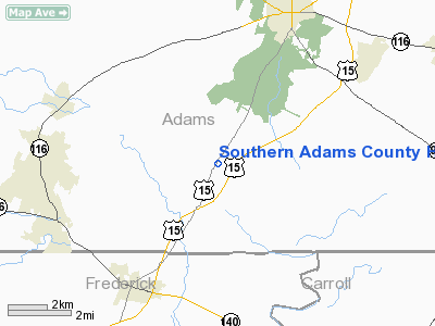
Southern Adams County Heliport |
Location & QuickFacts
| FAA Information Effective: | 2008-09-25 |
| Airport Identifier: | P98 |
| Airport Status: | Operational |
| Longitude/Latitude: | 077-16-30.9490W/39-45-40.3480N
-77.275264/39.761208 (Estimated) |
| Elevation: | 530 ft / 161.54 m (Estimated) |
| Land: | 14 acres |
| From nearest city: | 6 nautical miles S of Gettysburg, PA |
| Location: | Adams County, PA |
| Magnetic Variation: | 10W (1980) |
Owner & Manager
| Ownership: | Privately owned |
| Owner: | East Coast Helicopter, Inc. |
| Address: | 2812 Emmitsburg Rd
Gettysburg, PA 17325-7117 |
| Phone number: | 717-337-1515 |
| Manager: | George P. Kramer |
| Address: | 2812 Emmitsburg Rd
Gettysburg, PA 17325-7117 |
| Phone number: | 717-334-0280 |
Airport Operations and Facilities
| Airport Use: | Open to public |
| Wind indicator: | Yes |
| Segmented Circle: | No |
| Control Tower: | No |
| Landing fee charge: | No |
| Sectional chart: | Washington |
| Region: | AEA - Eastern |
| Boundary ARTCC: | ZNY - New York |
| Responsible ARTCC: | ZDC - Washington |
| Tie-in FSS: | IPT - Williamsport |
| FSS Toll Free: | 1-800-WX-BRIEF |
| NOTAMs Facility: | IPT (NOTAM-d service avaliable) |
Airport Communications
Airport Services
| Airframe Repair: | MAJOR |
| Power Plant Repair: | MAJOR |
Runway Information
Helipad H1
| Dimension: | 60 x 60 ft / 18.3 x 18.3 m |
| Surface: | CONC, Good Condition |
| |
Runway H1 |
Runway |
| Traffic Pattern: | Left | Left |
|
Radio Navigation Aids
| ID |
Type |
Name |
Ch |
Freq |
Var |
Dist |
| EUD | NDB | York | | 254.00 | 11W | 20.7 nm |
| GAI | NDB | Gaithersburg | | 385.00 | 09W | 35.9 nm |
| FND | NDB | Ellicott | | 371.00 | 11W | 36.7 nm |
| IUB | NDB | Institute | | 404.00 | 08W | 41.5 nm |
| BUH | NDB | Anne Arundel | | 260.00 | 10W | 47.2 nm |
| MTN | NDB | Martin | | 342.00 | 11W | 49.9 nm |
| MTN | TACAN | Martin | 068X | | 11W | 47.7 nm |
| FDK | VOR | Frederick | | 109.00 | 08W | 21.5 nm |
| HGR | VOR | Hagerstown | | 109.80 | 07W | 27.1 nm |
| EMI | VORTAC | Westminster | 126X | 117.90 | 08W | 21.1 nm |
| THS | VORTAC | St Thomas | 097X | 115.00 | 07W | 32.9 nm |
| HAR | VORTAC | Harrisburg | 072X | 112.50 | 10W | 33.9 nm |
| MRB | VORTAC | Martinsburg | 058X | 112.10 | 07W | 34.9 nm |
| BAL | VORTAC | Baltimore | 098X | 115.10 | 11W | 45.5 nm |
| MDT | VOT | Harrisburg International | | 110.00 | | 35.3 nm |
Remarks
- NOISE ABATEMENT PROCEDURES IN EFFECT; MAINTAIN 500 FT TIL INBOUND ON APCH HDG - AVOID OVERFLIGHT OF HOUSES N & S OF HELIPORT.
Images and information placed above are from
http://www.airport-data.com/airport/P98/
We thank them for the data!
| General Info
|
| Country |
United States
|
| State |
PENNSYLVANIA
|
| FAA ID |
P98
|
| Latitude |
39-45-40.348N
|
| Longitude |
077-16-30.949W
|
| Elevation |
530 feet
|
| Near City |
GETTYSBURG
|
We don't guarantee the information is fresh and accurate. The data may
be wrong or outdated.
For more up-to-date information please refer to other sources.
|
|


