 |
|
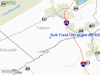
Solt Field Ultralight Airport |
Location & QuickFacts
| FAA Information Effective: | 2008-09-25 |
| Airport Identifier: | 9PA5 |
| Airport Status: | Operational |
| Longitude/Latitude: | 075-42-58.6800W/40-46-48.3370N
-75.716300/40.780094 (Estimated) |
| Elevation: | 520 ft / 158.50 m (Estimated) |
| Land: | 0 acres |
| From nearest city: | 4 nautical miles SW of Leighton, PA |
| Location: | Carbon County, PA |
| Magnetic Variation: | 12W (1990) |
Owner & Manager
| Ownership: | Privately owned |
| Owner: | Gregory Solt |
| Address: | Box 55
Ashfield, PA 18212 |
| Phone number: | 215-837-9421 |
| Manager: | Gregory Solt |
| Address: | Box 55
Ashfield, PA 18212 |
| Phone number: | 215-837-9421 |
Airport Operations and Facilities
| Airport Use: | Private |
| Segmented Circle: | No |
| Control Tower: | No |
| Sectional chart: | New York |
| Region: | AEA - Eastern |
| Boundary ARTCC: | ZNY - New York |
| Tie-in FSS: | IPT - Williamsport |
| FSS on Airport: | No |
| FSS Toll Free: | 1-800-WX-BRIEF |
Runway Information
Runway 08/26
| Dimension: | 600 x 200 ft / 182.9 x 61.0 m |
| Surface: | TURF, |
| |
Runway 08 |
Runway 26 |
| Traffic Pattern: | Left | Left |
| Obstruction: | | 40 ft trees, 1000.0 ft from runway |
|
Radio Navigation Aids
| ID |
Type |
Name |
Ch |
Freq |
Var |
Dist |
| LQX | NDB | Carbon | | 339.00 | 12W | 2.7 nm |
| HXM | NDB | Humbolt | | 366.00 | 10W | 17.9 nm |
| CYE | NDB | Crystal Lake | | 410.00 | 11W | 26.4 nm |
| UKT | NDB | Quakertown | | 208.00 | 12W | 28.7 nm |
| DYL | NDB | Doylestown | | 237.00 | 10W | 38.1 nm |
| BZJ | NDB | Bellgrove | | 328.00 | 10W | 43.4 nm |
| ING | NDB | Ambler | | 275.00 | 11W | 44.0 nm |
| NXX | NDB | Willow Grove | | 388.00 | 12W | 44.1 nm |
| NXX | TACAN | Willow Grove | 061X | | 10W | 43.8 nm |
| HZL | VOR | Hazleton | | 109.40 | 09W | 22.0 nm |
| ETX | VOR/DME | East Texas | 039X | 110.20 | 09W | 12.1 nm |
| CKZ | VOR/DME | Pennridge | 025Y | 108.85 | 12W | 30.5 nm |
| STW | VOR/DME | Stillwater | 033X | 109.60 | 11W | 40.6 nm |
| BWZ | VOR/DME | Broadway | 089X | 114.20 | 11W | 40.7 nm |
| SBJ | VOR/DME | Solberg | 076X | 112.90 | 10W | 46.0 nm |
| ARD | VOR/DME | Yardley | 019X | 108.20 | 10W | 48.7 nm |
| FJC | VORTAC | Allentown | 122X | 117.50 | 10W | 12.3 nm |
| LVZ | VORTAC | Wilkes-barre | 053X | 111.60 | 10W | 29.6 nm |
| PTW | VORTAC | Pottstown | 112X | 116.50 | 09W | 34.3 nm |
| RAV | VORTAC | Ravine | 093X | 114.60 | 11W | 42.5 nm |
| LHY | VORTAC | Lake Henry | 045X | 110.80 | 10W | 43.1 nm |
| MIP | VORTAC | Milton | 029X | 109.20 | 09W | 45.5 nm |
| LRP | VORTAC | Lancaster | 120X | 117.30 | 09W | 47.6 nm |
Remarks
- PRVDD CHURCH 1790 FT N & SCHOOL 1790 FT NE ARE AVOIDED DURING ANY/ALL FLIGHT ACTIVITY UTILIZING THIS FACILITY.
Images and information placed above are from
http://www.airport-data.com/airport/9PA5/
We thank them for the data!
| General Info
|
| Country |
United States
|
| State |
PENNSYLVANIA
|
| FAA ID |
9PA5
|
| Latitude |
40-46-48.337N
|
| Longitude |
075-42-58.680W
|
| Elevation |
520 feet
|
| Near City |
LEIGHTON
|
We don't guarantee the information is fresh and accurate. The data may
be wrong or outdated.
For more up-to-date information please refer to other sources.
|
|


