 |
|
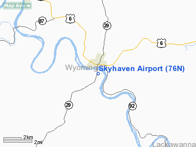
Location & QuickFacts
| FAA Information Effective: | 2008-09-25 |
| Airport Identifier: | 76N |
| Airport Status: | Operational |
| Longitude/Latitude: | 075-56-48.7170W/41-31-45.2760N
-75.946866/41.529243 (Estimated) |
| Elevation: | 639 ft / 194.77 m (Estimated) |
| Land: | 31 acres |
| From nearest city: | 1 nautical miles S of Tunkhannock, PA |
| Location: | Wyoming County, PA |
| Magnetic Variation: | 12W (1985) |
Owner & Manager
| Ownership: | Privately owned |
| Owner: | Steve Gay |
| Address: | 17 Runway Rd
Tunkhannock, PA 18657 |
| Phone number: | 570-836-3884 |
| Manager: | Steve Gay |
| Address: | 25 Runway Rd
Tunkhannock, PA 18657 |
| Phone number: | 570-836-4800 |
Airport Operations and Facilities
| Airport Use: | Open to public |
| Wind indicator: | Yes |
| Segmented Circle: | No |
| Control Tower: | No |
| Lighting Schedule: | NONE |
| Landing fee charge: | No |
| Sectional chart: | New York |
| Region: | AEA - Eastern |
| Traffic Pattern Alt: | 961 ft |
| Boundary ARTCC: | ZNY - New York |
| Tie-in FSS: | IPT - Williamsport |
| FSS on Airport: | No |
| FSS Toll Free: | 1-800-WX-BRIEF |
| NOTAMs Facility: | IPT (NOTAM-d service avaliable) |
Airport Communications
| CTAF: | 122.800 |
| Unicom: | 122.800 |
Airport Services
| Fuel available: | MOGAS |
| Airframe Repair: | MAJOR |
| Power Plant Repair: | MAJOR |
| Bottled Oxygen: | NONE |
| Bulk Oxygen: | NONE |
Runway Information
Runway 01/19
| Dimension: | 2007 x 50 ft / 611.7 x 15.2 m |
| Surface: | ASPH, Good Condition |
| Weight Limit: | Single wheel: 12500 lbs. |
| |
Runway 01 |
Runway 19 |
| Traffic Pattern: | Left | Left |
| Markings: | Basic, Good Condition | Basic, Good Condition |
| Displaced threshold: | 225.00 ft | 438.00 ft |
| Obstruction: | 49 ft tree, 1030.0 ft from runway, 200 ft right of centerline, 16:1 slope to clear
APCH SLOPE 25:1 TO DSPLCD THLD.
PRIVATE ROAD +10 FT; 1 FT FM RY END; EXTENDS ACROSS THR. | 50 ft pole, 553.0 ft from runway, 158 ft left of centerline, 7:1 slope to clear
APCH SLOPE 19:1 TO DSPLCD THLD.
+22 FT BRUSH 155 FT FM RY END 90 FT RIGHT. |
|
Radio Navigation Aids
| ID |
Type |
Name |
Ch |
Freq |
Var |
Dist |
| CYE | NDB | Crystal Lake | | 410.00 | 11W | 19.9 nm |
| HXM | NDB | Humbolt | | 366.00 | 10W | 32.6 nm |
| PIX | NDB | Picture Rocks | | 344.00 | 09W | 37.6 nm |
| LQX | NDB | Carbon | | 339.00 | 12W | 43.9 nm |
| HZL | VOR | Hazleton | | 109.40 | 09W | 34.3 nm |
| FQM | VOR/DME | Williamsport | 091X | 114.40 | 09W | 39.0 nm |
| HNK | VOR/DME | Hancock | 115X | 116.80 | 11W | 42.8 nm |
| LVZ | VORTAC | Wilkes-barre | 053X | 111.60 | 10W | 19.3 nm |
| LHY | VORTAC | Lake Henry | 045X | 110.80 | 10W | 21.1 nm |
| CFB | VORTAC | Binghamton | 059X | 112.20 | 10W | 38.7 nm |
| MIP | VORTAC | Milton | 029X | 109.20 | 09W | 44.5 nm |
Remarks
Images and information placed above are from
http://www.airport-data.com/airport/76N/
We thank them for the data!
| General Info
|
| Country |
United States
|
| State |
PENNSYLVANIA
|
| FAA ID |
76N
|
| Latitude |
41-31-45.276N
|
| Longitude |
075-56-48.717W
|
| Elevation |
639 feet
|
| Near City |
TUNKHANNOCK
|
We don't guarantee the information is fresh and accurate. The data may
be wrong or outdated.
For more up-to-date information please refer to other sources.
|
|


