 |
|
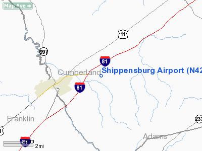
Location & QuickFacts
| FAA Information Effective: | 2008-09-25 |
| Airport Identifier: | N42 |
| Airport Status: | Operational |
| Longitude/Latitude: | 077-27-43.9490W/40-03-30.3230N
-77.462208/40.058423 (Estimated) |
| Elevation: | 760 ft / 231.65 m (Estimated) |
| Land: | 80 acres |
| From nearest city: | 3 nautical miles NE of Shippensburg, PA |
| Location: | Cumberland County, PA |
| Magnetic Variation: | 10W (1985) |
Owner & Manager
| Ownership: | Privately owned |
| Owner: | Mrs Ellen E Baer |
| Address: | 20 Airport Lane
Shippensburg, PA 17257-9600 |
| Phone number: | 717-532-2065 |
| Manager: | James Baer |
| Address: | 625 Prospect Avenue
Shippensburg, PA 17257-8945 |
| Phone number: | 717-532-2065 |
Airport Operations and Facilities
| Airport Use: | Open to public |
| Wind indicator: | Yes |
| Segmented Circle: | No |
| Control Tower: | No |
| Landing fee charge: | No |
| Sectional chart: | Detroit |
| Region: | AEA - Eastern |
| Traffic Pattern Alt: | 800 ft |
| Boundary ARTCC: | ZNY - New York |
| Tie-in FSS: | IPT - Williamsport |
| FSS on Airport: | No |
| FSS Toll Free: | 1-800-WX-BRIEF
FOR PICKUP CLEARANCE TOLL FREE CALL 800-932-0712. |
| NOTAMs Facility: | IPT (NOTAM-d service avaliable) |
Airport Communications
Airport Services
Runway Information
Runway 07/25
| Dimension: | 2300 x 170 ft / 701.0 x 51.8 m |
| Surface: | TURF, Good Condition |
| |
Runway 07 |
Runway 25 |
| Traffic Pattern: | Left | Left |
| Displaced threshold: | 535.00 ft | 595.00 ft |
| Obstruction: | 9 ft brush, 45.0 ft from runway, 5:1 slope to clear
RY 07 APCH RATIO 50:1 TO DSPLCD THLD. | 10 ft brush, 78.0 ft from runway, 98 ft right of centerline, 7:1 slope to clear
RY 25 APCH RATIO 50:1 TO DSPLCD THLD. |
|
Radio Navigation Aids
| ID |
Type |
Name |
Ch |
Freq |
Var |
Dist |
| EUD | NDB | York | | 254.00 | 11W | 28.2 nm |
| RV | NDB | Stroh | | 407.00 | 10W | 35.4 nm |
| BZJ | NDB | Bellgrove | | 328.00 | 10W | 47.5 nm |
| HGR | VOR | Hagerstown | | 109.80 | 07W | 28.3 nm |
| FDK | VOR | Frederick | | 109.00 | 08W | 39.0 nm |
| AOO | VOR | Altoona | | 108.80 | 07W | 41.8 nm |
| HAR | VORTAC | Harrisburg | 072X | 112.50 | 10W | 23.2 nm |
| THS | VORTAC | St Thomas | 097X | 115.00 | 07W | 23.7 nm |
| EMI | VORTAC | Westminster | 126X | 117.90 | 08W | 40.6 nm |
| MRB | VORTAC | Martinsburg | 058X | 112.10 | 07W | 44.2 nm |
| RAV | VORTAC | Ravine | 093X | 114.60 | 11W | 49.5 nm |
| MDT | VOT | Harrisburg International | | 110.00 | | 33.2 nm |
Remarks
Images and information placed above are from
http://www.airport-data.com/airport/N42/
We thank them for the data!
| General Info
|
| Country |
United States
|
| State |
PENNSYLVANIA
|
| FAA ID |
N42
|
| Latitude |
40-03-30.323N
|
| Longitude |
077-27-43.949W
|
| Elevation |
760 feet
|
| Near City |
SHIPPENSBURG
|
We don't guarantee the information is fresh and accurate. The data may
be wrong or outdated.
For more up-to-date information please refer to other sources.
|
|


