 |
|
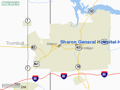
Sharon General Hospital Heliport |
Location & QuickFacts
| FAA Information Effective: | 2008-09-25 |
| Airport Identifier: | PA94 |
| Airport Status: | Operational |
| Longitude/Latitude: | 080-29-47.2530W/41-13-57.2010N
-80.496459/41.232556 (Estimated) |
| Elevation: | 980 ft / 298.70 m (Estimated) |
| Land: | 0 acres |
| From nearest city: | 0 nautical miles N of Sharon, PA |
| Location: | Mercer County, PA |
| Magnetic Variation: | 07W (1985) |
Owner & Manager
| Ownership: | Privately owned |
| Owner: | Sharon Regional Health Sys |
| Address: | 740 E. State Street
Sharon, PA 16146 |
| Phone number: | 412-983-3911 |
| Manager: | Thomas Young |
| Address: | 740 E. State Street
Sharon, PA 16146 |
| Phone number: | 412-983-3911
EXT. 3829. |
Airport Operations and Facilities
| Airport Use: | Private
MEDICAL USE. |
| Wind indicator: | Yes |
| Segmented Circle: | No |
| Control Tower: | No |
| Lighting Schedule: | PHONE REQ
FOR PERIMETER LIGHTS CALL 412-983-3911. |
| Landing fee charge: | No |
| Sectional chart: | Detroit |
| Region: | AEA - Eastern |
| Boundary ARTCC: | ZOB - Cleveland |
| Tie-in FSS: | AOO - Altoona |
| FSS on Airport: | No |
| FSS Toll Free: | 1-800-WX-BRIEF |
Runway Information
Helipad H1
| Dimension: | 65 x 65 ft / 19.8 x 19.8 m |
| Surface: | CONC, |
| |
Runway H1 |
Runway |
| Traffic Pattern: | Left | Left |
|
Radio Navigation Aids
| ID |
Type |
Name |
Ch |
Freq |
Var |
Dist |
| HBD | NDB | Hubbard | | 408.00 | 08W | 5.0 nm |
| UCP | NDB | Castle | | 272.00 | 09W | 13.1 nm |
| AK | NDB | Akron | | 362.00 | 07W | 41.5 nm |
| LQL | NDB | Lakeland | | 263.00 | 08W | 48.1 nm |
| TSO | NDB | Tolson | | 395.00 | 07W | 48.2 nm |
| FKL | VOR | Franklin | | 109.60 | 06W | 31.4 nm |
| ACO | VOR/DME | Akron | 091X | 114.40 | 04W | 32.8 nm |
| JFN | VOR/DME | Jefferson | 099X | 115.20 | 05W | 33.7 nm |
| CXR | VOR/DME | Chardon | 074X | 112.70 | 05W | 34.6 nm |
| CIP | VOR/DME | Clarion | 076X | 112.90 | 06W | 47.3 nm |
| LNN | VOR/DME | Lost Nation | 039X | 110.20 | 08W | 48.5 nm |
| YNG | VORTAC | Youngstown | 027X | 109.00 | 05W | 10.0 nm |
| EWC | VORTAC | Ellwood City | 105X | 115.80 | 08W | 27.7 nm |
| MMJ | VORTAC | Montour | 057X | 112.00 | 08W | 46.8 nm |
| ERI | VORTAC | Erie | 031X | 109.40 | 06W | 48.1 nm |
| CAK | VOT | Akron/canton Regional | | 110.60 | | 46.9 nm |
Images and information placed above are from
http://www.airport-data.com/airport/PA94/
We thank them for the data!
| General Info
|
| Country |
United States
|
| State |
PENNSYLVANIA
|
| FAA ID |
PA94
|
| Latitude |
41-13-57.201N
|
| Longitude |
080-29-47.253W
|
| Elevation |
980 feet
|
| Near City |
SHARON
|
We don't guarantee the information is fresh and accurate. The data may
be wrong or outdated.
For more up-to-date information please refer to other sources.
|
|


