 |
|
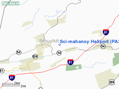
Location & QuickFacts
| FAA Information Effective: | 2008-09-25 |
| Airport Identifier: | PA37 |
| Airport Status: | Operational |
| Longitude/Latitude: | 076-09-43.7400W/40-49-15.3100N
-76.162150/40.820919 (Estimated) |
| Elevation: | 1500 ft / 457.20 m (Estimated) |
| Land: | 0 acres |
| From nearest city: | 1 nautical miles SE of Mahanoy, PA |
| Location: | Schuylkill County, PA |
| Magnetic Variation: | 12W (1995) |
Owner & Manager
| Ownership: | Publicly owned |
| Owner: | Pa Dept Of Corr-sci Mahoney |
| Address: | 301 Morea Rd
Frackville, PA 17932 |
| Phone number: | 717-773-2158 |
| Manager: | Edward J Slane |
| Address: | 301 Morea Rd
Frackville, PA 17932 |
| Phone number: | 717-773-2158 |
Airport Operations and Facilities
| Airport Use: | Private |
| Wind indicator: | Yes |
| Segmented Circle: | No |
| Control Tower: | No |
| Lighting Schedule: | PHONE REQ
FOR PERIMETER LGTS CALL 717-773-2158. |
| Sectional chart: | New York |
| Region: | AEA - Eastern |
| Boundary ARTCC: | ZNY - New York |
| Tie-in FSS: | IPT - Williamsport |
| FSS on Airport: | No |
| FSS Toll Free: | 1-800-WX-BRIEF |
Runway Information
Helipad H1
| Dimension: | 65 x 65 ft / 19.8 x 19.8 m |
| Surface: | ASPH, |
| |
Runway H1 |
Runway |
| Traffic Pattern: | Left | Left |
|
Radio Navigation Aids
| ID |
Type |
Name |
Ch |
Freq |
Var |
Dist |
| HXM | NDB | Humbolt | | 366.00 | 10W | 12.6 nm |
| LQX | NDB | Carbon | | 339.00 | 12W | 18.3 nm |
| CYE | NDB | Crystal Lake | | 410.00 | 11W | 27.8 nm |
| BZJ | NDB | Bellgrove | | 328.00 | 10W | 29.2 nm |
| PIX | NDB | Picture Rocks | | 344.00 | 09W | 37.0 nm |
| UKT | NDB | Quakertown | | 208.00 | 12W | 46.1 nm |
| HZL | VOR | Hazleton | | 109.40 | 09W | 9.4 nm |
| ETX | VOR/DME | East Texas | 039X | 110.20 | 09W | 26.1 nm |
| FQM | VOR/DME | Williamsport | 091X | 114.40 | 09W | 41.7 nm |
| CKZ | VOR/DME | Pennridge | 025Y | 108.85 | 12W | 47.5 nm |
| RAV | VORTAC | Ravine | 093X | 114.60 | 11W | 25.6 nm |
| MIP | VORTAC | Milton | 029X | 109.20 | 09W | 25.9 nm |
| FJC | VORTAC | Allentown | 122X | 117.50 | 10W | 32.7 nm |
| SEG | VORTAC | Selinsgrove | 041X | 110.40 | 08W | 32.9 nm |
| LVZ | VORTAC | Wilkes-barre | 053X | 111.60 | 10W | 34.6 nm |
| LRP | VORTAC | Lancaster | 120X | 117.30 | 09W | 42.5 nm |
| PTW | VORTAC | Pottstown | 112X | 116.50 | 09W | 45.3 nm |
| LHY | VORTAC | Lake Henry | 045X | 110.80 | 10W | 50.0 nm |
| MDT | VOT | Harrisburg International | | 110.00 | | 46.5 nm |
Remarks
- PRVDD LARGEST CLASS OF HELICOPTER SHOULD WEIGH LESS THAN 12500 LBS; IFR OPNS ARE NOT CONDUCTED; APPROPRIATE FENCINGS; MARKINGS & WINDSOCK INSTALLED; OIVERFLIGHT OF SCHOOLS & OTHER AREAS IF PUBLIC ASSEMBLY SHOULD BE AVOIDED & THERE IS A CLEAR 8:1 APCH.
Images and information placed above are from
http://www.airport-data.com/airport/PA37/
We thank them for the data!
| General Info
|
| Country |
United States
|
| State |
PENNSYLVANIA
|
| FAA ID |
PA37
|
| Latitude |
40-49-15.310N
|
| Longitude |
076-09-43.740W
|
| Elevation |
1500 feet
|
| Near City |
MAHANOY
|
We don't guarantee the information is fresh and accurate. The data may
be wrong or outdated.
For more up-to-date information please refer to other sources.
|
|


