 |
|
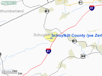
Schuylkill County /joe Zerbey/ Airport |
Schuylkill County Airport
Schuylkill County/Joe Zerbey Airport |
| IATA: none – ICAO: KZER – FAA LID: ZER |
| Summary |
| Airport type |
Public |
| Owner |
Schuylkill County Airport Authority |
| Location |
Pottsville, Pennsylvania |
| Elevation AMSL |
1,734 ft / 529 m |
| Coordinates |
40°42′23″N 076°22′23″W / 40.70639°N 76.37306°W / 40.70639; -76.37306 |
| Runways |
| Direction |
Length |
Surface |
| ft |
m |
| 11/29 |
4,594 |
1,400 |
Asphalt |
| 4/22 |
2,270 |
692 |
Turf |
Schuylkill County Airport (ICAO: KZER, FAA LID: ZER), also known as Schuylkill County/Joe Zerbey Airport, is a public-use airport located eight miles (13 km) west of the central business district of Pottsville, a city in Schuylkill County, Pennsylvania, United States. This airport is publicly owned by Schuylkill County Airport Authority. It is mostly used for general aviation, but is served by one charter service.
Although most U.S. airports use the same three-letter location identifier for the FAA and IATA, Schuylkill County Airport is assigned ZER by the FAA but has no designation from the IATA (which assigned ZER to Zero Airport in Zero, Arunachal Pradesh, India). The airport's ICAO identifier is KZER. Facilities
Schuylkill County Airport covers an area of 34 acres (14 ha) which contains two runways:
- Runway 4/22: 2,270 x 140 ft (692 x 43 m), Surface: Turf
- Runway 11/29: 4,594 x 75 ft (1,400 x 23 m), Surface: Asphalt
Charter Service
The above content comes from Wikipedia and is published under free licenses – click here to read more.
Location & QuickFacts
| FAA Information Effective: | 2008-09-25 |
| Airport Identifier: | ZER |
| Airport Status: | Operational |
| Longitude/Latitude: | 076-22-23.3000W/40-42-23.3000N
-76.373139/40.706472 (Estimated) |
| Elevation: | 1729 ft / 527.00 m (Surveyed) |
| Land: | 34 acres |
| From nearest city: | 8 nautical miles W of Pottsville, PA |
| Location: | Schuylkill County, PA |
| Magnetic Variation: | 12W (2000) |
Owner & Manager
| Ownership: | Publicly owned |
| Owner: | Schuylkill County A/p Auth |
| Address: | Po Box 674
Pottsville, PA 17901 |
| Phone number: | 570-544-6002 |
| Manager: | Ray Green |
| Address: | 240 Airport Road
Pottsville, PA 17901 |
| Phone number: | 570-544-6002 |
Airport Operations and Facilities
| Airport Use: | Open to public |
| Wind indicator: | Yes |
| Segmented Circle: | No |
| Control Tower: | No |
| Lighting Schedule: | DUSK-DAWN
ACTIVATE MIRL RY 11/29, REIL & PAPI RYS 11& 29 - CTAF. |
| Beacon Color: | Clear-Green (lighted land airport) |
| Landing fee charge: | No |
| Sectional chart: | New York |
| Region: | AEA - Eastern |
| Traffic Pattern Alt: | 771 ft |
| Boundary ARTCC: | ZNY - New York |
| Tie-in FSS: | IPT - Williamsport |
| FSS on Airport: | No |
| FSS Toll Free: | 1-800-WX-BRIEF
FOR PICKUP CLEARANCE CALL TOLL FREE CALL 800-932-0712. |
| NOTAMs Facility: | IPT (NOTAM-d service avaliable) |
| Federal Agreements: | NGY |
Airport Communications
| CTAF: | 122.800 |
| Unicom: | 122.800 |
Airport Services
| Fuel available: | 100LLA
AVGAS SELF SERVE WITH CREDIT CARD. |
| Bottled Oxygen: | NONE |
| Bulk Oxygen: | NONE |
Runway Information
Runway 04/22
| Dimension: | 2270 x 140 ft / 691.9 x 42.7 m |
| Surface: | TURF, Good Condition |
| |
Runway 04 |
Runway 22 |
| Longitude: | 076-22-13.9185W | 076-21-58.7400W |
| Latitude: | 40-42-20.2067N | 40-42-39.4300N |
| Alignment: | 31 | 127 |
| Traffic Pattern: | Left | Left |
| Displaced threshold: | 0.00 ft | 200.00 ft |
| Obstruction: | 21 ft trees, 479.0 ft from runway, 273 ft right of centerline, 22:1 slope to clear | 30 ft brush, 630.0 ft from runway, 218 ft right of centerline, 21:1 slope to clear
APCH RATIO 27:1 TO DSPLCD THLD. |
|
Runway 11/29
| Dimension: | 4594 x 75 ft / 1400.3 x 22.9 m |
| Surface: | ASPH, Good Condition |
| Weight Limit: | Single wheel: 21000 lbs. |
| Edge Lights: | Medium |
| |
Runway 11 |
Runway 29 |
| Longitude: | 076-23-01.2890W | 076-22-02.1403W |
| Latitude: | 40-42-23.1515N | 40-42-16.9210N |
| Elevation: | 1729.00 ft | 1706.00 ft |
| Alignment: | 98 | 127 |
| Traffic Pattern: | Left | Left |
| Markings: | Non-precision instrument, Good Condition | Non-precision instrument, Good Condition |
| Crossing Height: | 40.00 ft | 40.00 ft |
| VASI: | 2-light PAPI on left side | 2-light PAPI on left side |
| Visual Glide Angle: | 3.00° | 3.00° |
| Runway End Identifier: | Yes | Yes |
| Obstruction: | 7 ft trees, 368.0 ft from runway, 268 ft right of centerline, 24:1 slope to clear | 5 ft trees, 216.0 ft from runway, 89 ft right of centerline, 3:1 slope to clear
RY 29 HAS BRUSH 86 FT OUT AND 236 FT RIGHT 7 FT HIGH. |
|
Radio Navigation Aids
| ID |
Type |
Name |
Ch |
Freq |
Var |
Dist |
| BZJ | NDB | Bellgrove | | 328.00 | 10W | 18.2 nm |
| HXM | NDB | Humbolt | | 366.00 | 10W | 24.1 nm |
| LQX | NDB | Carbon | | 339.00 | 12W | 28.7 nm |
| PIX | NDB | Picture Rocks | | 344.00 | 09W | 37.5 nm |
| CYE | NDB | Crystal Lake | | 410.00 | 11W | 39.0 nm |
| HZL | VOR | Hazleton | | 109.40 | 09W | 19.7 nm |
| ETX | VOR/DME | East Texas | 039X | 110.20 | 09W | 32.3 nm |
| FQM | VOR/DME | Williamsport | 091X | 114.40 | 09W | 42.1 nm |
| RAV | VORTAC | Ravine | 093X | 114.60 | 11W | 13.8 nm |
| MIP | VORTAC | Milton | 029X | 109.20 | 09W | 23.2 nm |
| SEG | VORTAC | Selinsgrove | 041X | 110.40 | 08W | 23.8 nm |
| LRP | VORTAC | Lancaster | 120X | 117.30 | 09W | 35.5 nm |
| HAR | VORTAC | Harrisburg | 072X | 112.50 | 10W | 40.0 nm |
| FJC | VORTAC | Allentown | 122X | 117.50 | 10W | 41.9 nm |
| LVZ | VORTAC | Wilkes-barre | 053X | 111.60 | 10W | 46.1 nm |
| PTW | VORTAC | Pottstown | 112X | 116.50 | 09W | 47.2 nm |
| MDT | VOT | Harrisburg International | | 110.00 | | 35.4 nm |
Remarks
- DEER ON & INVOF ARPT.
- ULTRA LIGHTS ON & INVOF ARPT
Images and information placed above are from
http://www.airport-data.com/airport/ZER/
We thank them for the data!
| General Info
|
| Country |
United States
|
| State |
PENNSYLVANIA
|
| FAA ID |
ZER
|
| Latitude |
40-42-23.216N
|
| Longitude |
076-22-23.328W
|
| Elevation |
1734 feet
|
| Near City |
POTTSVILLE
|
We don't guarantee the information is fresh and accurate. The data may
be wrong or outdated.
For more up-to-date information please refer to other sources.
|
|


