 |
|
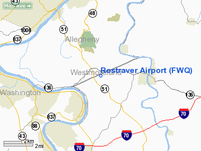
| Rostraver Airport |
| IATA: none – ICAO: KFWQ – FAA LID: FWQ |
| Summary |
| Airport type |
Public |
| Owner |
Westmoreland County Airport Authority |
| Serves |
Monongahela, Pennsylvania |
| Location |
Rostraver Township, Pennsylvania |
| Elevation AMSL |
1,228 ft / 374 m |
| Coordinates |
40°12′35″N 079°49′53″W / 40.20972°N 79.83139°W / 40.20972; -79.83139 |
| Runways |
| Direction |
Length |
Surface |
| ft |
m |
| 8/26 |
4,001 |
1,220 |
Asphalt |
| Statistics (2009) |
| Aircraft operations |
43,542 |
| Based aircraft |
113 |
| Source: Federal Aviation Administration |
Rostraver Airport (ICAO: KFWQ, FAA LID: FWQ, formerly P53) is a public use airport in Westmoreland County, Pennsylvania, United States. It is located five nautical miles (9 km) east of the central business district of Monongahela, Pennsylvania (a suburb of Pittsburgh) in Rostraver Township. It is operated by the Westmoreland County Airport Authority, which also operates the Arnold Palmer Regional Airport in Unity Township, Pennsylvania.
Although most U.S. airports use the same three-letter location identifier for the FAA and IATA, this airport is assigned FWQ by the FAA but has no designation from the IATA.
Facilities and aircraft
Rostraver Airport covers an area of 300 acres (121 ha) at an elevation of 1,228 feet (374 m) above mean sea level. It has one asphalt paved runway designated 8/26 which measures 4,001 by 75 feet (1,220 x 23 m).
For the 12-month period ending April 22, 2009, the airport had 43,542 aircraft operations, an average of 119 per day: 98% general aviation, 2% air taxi and <1% military. At that time there were 113 aircraft based at this airport: 84% single-engine, 11% multi-engine, 4% helicopter, 1% glider and 1% ultralight.
The above content comes from Wikipedia and is published under free licenses – click here to read more.
Location & QuickFacts
| FAA Information Effective: | 2008-09-25 |
| Airport Identifier: | FWQ |
| Airport Status: | Operational |
| Longitude/Latitude: | 079-49-53.2000W/40-12-35.0000N
-79.831444/40.209722 (Estimated) |
| Elevation: | 1228 ft / 374.29 m (Surveyed) |
| Land: | 300 acres |
| From nearest city: | 5 nautical miles E of Monongahela, PA |
| Location: | Westmoreland County, PA |
| Magnetic Variation: | 09W (2005) |
Owner & Manager
| Ownership: | Publicly owned |
| Owner: | Westmoreland Co Arpt Auth |
| Address: | 148 Aviation Lane, Suite 103
Latrobe, PA 15650 |
| Phone number: | 724-539-8100 |
| Manager: | Gabe Monzo |
| Address: | 605 Airport Rd
Belle Vernon, PA 15012 |
| Phone number: | 724-379-6980 |
Airport Operations and Facilities
| Airport Use: | Open to public |
| Wind indicator: | Yes |
| Segmented Circle: | Yes |
| Control Tower: | No |
| Lighting Schedule: | DUSK-DAWN
ACTVT MIRL RY 08/26, VASI RYS 08 & 26, REIL RYS 08 & 26 - CTAF. |
| Beacon Color: | Clear-Green (lighted land airport) |
| Landing fee charge: | No |
| Sectional chart: | Detroit |
| Region: | AEA - Eastern |
| Boundary ARTCC: | ZOB - Cleveland |
| Tie-in FSS: | AOO - Altoona |
| FSS on Airport: | No |
| FSS Toll Free: | 1-800-WX-BRIEF |
| NOTAMs Facility: | AOO (NOTAM-d service avaliable) |
| Federal Agreements: | NGY |
Airport Communications
| CTAF: | 122.800 |
| Unicom: | 122.800 |
Airport Services
| Fuel available: | 100LLA |
| Airframe Repair: | MAJOR |
| Power Plant Repair: | MAJOR |
| Bottled Oxygen: | NONE |
| Bulk Oxygen: | NONE |
Runway Information
Runway 08/26
| Dimension: | 4001 x 75 ft / 1219.5 x 22.9 m |
| Surface: | ASPH, Good Condition |
| Surface Treatment: | Saw-cut or plastic Grooved |
| Weight Limit: | Single wheel: 26000 lbs.
Dual wheel: 30000 lbs. |
| Edge Lights: | Medium |
| |
Runway 08 |
Runway 26 |
| Longitude: | 079-50-17.0562W | 079-49-29.4296W |
| Latitude: | 40-12-27.4397N | 40-12-42.5981N |
| Elevation: | 1228.00 ft | 1223.00 ft |
| Alignment: | 67 | 127 |
| Traffic Pattern: | Left | Left |
| Markings: | Non-precision instrument, Good Condition | Non-precision instrument, Good Condition |
| Crossing Height: | 53.00 ft | 50.00 ft |
| VASI: | 4-box on right side | 4-box on left side |
| Visual Glide Angle: | 3.00° | 3.00° |
| Runway End Identifier: | Yes | Yes |
| Obstruction: | 8 ft brush, 226.0 ft from runway, 183 ft right of centerline, 3:1 slope to clear | 66 ft trees, 2270.0 ft from runway, 3 ft left of centerline, 31:1 slope to clear |
|
Radio Navigation Aids
| ID |
Type |
Name |
Ch |
Freq |
Var |
Dist |
| MKP | NDB | Mc Keesport | | 287.00 | 07W | 9.0 nm |
| PNU | NDB | Washington County | | 255.00 | 08W | 15.7 nm |
| VV | NDB | Camor | | 299.00 | 08W | 20.1 nm |
| BHU | NDB | Benje | | 382.00 | 07W | 27.5 nm |
| SYS | NDB | Stoystown | | 209.00 | 08W | 42.7 nm |
| INP | NDB | Indiana | | 242.00 | 08W | 43.3 nm |
| AGC | VOR/DME | Allegheny | 037X | 110.00 | 09W | 10.5 nm |
| HLG | VOR/DME | Wheeling | 059X | 112.20 | 07W | 34.0 nm |
| AIR | VOR/DME | Bellaire | 118X | 117.10 | 07W | 46.8 nm |
| GRV | VOR/DME | Grantsville | 070X | 112.30 | 06W | 49.9 nm |
| MMJ | VORTAC | Montour | 057X | 112.00 | 08W | 23.6 nm |
| IHD | VORTAC | Indian Head | 019X | 108.20 | 06W | 26.0 nm |
| MGW | VORTAC | Morgantown | 053X | 111.60 | 05W | 39.3 nm |
| EWC | VORTAC | Ellwood City | 105X | 115.80 | 08W | 40.9 nm |
| JST | VORTAC | Johnstown | 077X | 113.00 | 06W | 46.2 nm |
Remarks
- DEER & BIRDS ON & INVOF ARPT.
Images and information placed above are from
http://www.airport-data.com/airport/FWQ/
We thank them for the data!
| General Info
|
| Country |
United States
|
| State |
PENNSYLVANIA
|
| FAA ID |
FWQ
|
| Time |
UTC-5(-4DT)
|
| Latitude |
40.209721
40° 12' 35.00" N
|
| Longitude |
-79.831444
079° 49' 53.20" W
|
| Elevation |
1228 feet
374 meters
|
| Type |
Civil
|
| Magnetic Variation |
009° W (01/06)
|
| Beacon |
Yes
|
| Operating Agency |
U.S.CIVIL AIRPORT WHEREIN PERMIT COVERS USE BY TRANSIT MILITARY AIRCRAFT
|
| Near City |
Monongahela
|
| Operating Hours |
SEE REMARKS FOR OPERATING HOURS OR COMMUNICATIONS FOR POSSIBLE HOURS
|
| Daylight Saving Time |
Second Sunday in March at 0200 to first Sunday in November at 0200 local time (Exception Arizona and that portion of Indiana in the Eastern Time Zone)
|
We don't guarantee the information is fresh and accurate. The data may
be wrong or outdated.
For more up-to-date information please refer to other sources.
|
|


