 |
|
Coordinates: 40°36′25″N 79°49′24″W / 40.60694°N 79.82333°W / 40.60694; -79.82333
Rock Airport
West Penn Airport |
| IATA: none – ICAO: none – FAA LID: 9G1 |
| Summary |
| Airport type |
Public |
| Serves |
Tarentum, Pennsylvania |
| Location |
Indiana Township, West Deer Township, Pennsylvania |
| Elevation AMSL |
1,125 ft / 343 m |
| Website |
www.rock-airport |
| Runways |
| Direction |
Length |
Surface |
| ft |
m |
| 17/35 |
3,550 |
1,082 |
Asphalt |
| Statistics (2008) |
| Aircraft operations |
14,600 |
| Based aircraft |
12 |
| Source: Federal Aviation Administration |
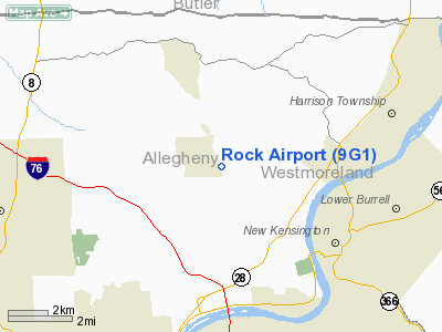
Rock Airport (FAA LID: 9G1) (originally known as West Penn Airport) is an airport northeast of Pittsburgh, Pennsylvania near the boroughs of Tarentum and Springdale.
The property went through a major overhaul between 2000 and 2004, and can now accommodate larger aircraft. The airport is located a few miles north of Pittsburgh Mills shopping mall, which is a major attraction in the Pittsburgh area.
The above content comes from Wikipedia and is published under free licenses – click here to read more.
Location & QuickFacts
| FAA Information Effective: | 2008-09-25 |
| Airport Identifier: | 9G1 |
| Airport Status: | Operational |
| Longitude/Latitude: | 079-49-34.0282W/40-36-12.7666N
-79.826119/40.603546 (Estimated) |
| Elevation: | 1063 ft / 324.00 m (Estimated) |
| Land: | 149 acres |
| From nearest city: | 12 nautical miles NN of Pittsburgh, PA |
| Location: | Allegheny County, PA |
| Magnetic Variation: | 09W (2010) |
Owner & Manager
| Ownership: | Privately owned |
| Owner: | Rock Airport Of Pittsburgh Llc |
| Address: | 1000 Rockpointe Blvd
Pittsburgh, PA 15084 |
| Phone number: | 724-265-1144 |
| Manager: | George Hollibaugh |
| Address: | 1000 Rockpointe Blvd
Pittsburgh, PA 15084 |
| Phone number: | 724-265-1144 |
Airport Operations and Facilities
| Airport Use: | Open to public |
| Wind indicator: | Yes |
| Control Tower: | No |
| Lighting Schedule: | DUSK-0000
ARPT LIGHTING INOP, ARPT CLSD FOR NIGHT OPS INDEFLY. |
| Landing fee charge: | No |
| Sectional chart: | Detroit |
| Region: | AEA - Eastern |
| Boundary ARTCC: | ZOB - Cleveland |
| Tie-in FSS: | AOO - Altoona |
| FSS on Airport: | No |
| FSS Toll Free: | 1-800-WX-BRIEF |
| NOTAMs Facility: | AOO (NOTAM-d service avaliable) |
| Federal Agreements: | N |
Airport Communications
| CTAF: | 122.800 |
| Unicom: | 122.800 |
Airport Services
| Bottled Oxygen: | NONE |
| Bulk Oxygen: | NONE |
Runway Information
Runway 17/35
| Dimension: | 3550 x 100 ft / 1082.0 x 30.5 m |
| Surface: | ASPH, Good Condition |
| Edge Lights: | High
OTS INDEFLY. |
| |
Runway 17 |
Runway 35 |
| Longitude: | 079-49-40.2473W | 079-49-27.8090W |
| Latitude: | 40-36-29.6539N | 40-35-55.8792N |
| Elevation: | 1063.00 ft | 1055.00 ft |
| Traffic Pattern: | Left | Left |
| Obstruction: | 122 ft trees, 1812.0 ft from runway, 257 ft left of centerline, 13:1 slope to clear | 33 ft road, 657.0 ft from runway, 63 ft right of centerline, 13:1 slope to clear |
|
Radio Navigation Aids
| ID |
Type |
Name |
Ch |
Freq |
Var |
Dist |
| MKP | NDB | Mc Keesport | | 287.00 | 07W | 15.1 nm |
| BHU | NDB | Benje | | 382.00 | 07W | 28.8 nm |
| PNU | NDB | Washington County | | 255.00 | 08W | 31.6 nm |
| INP | NDB | Indiana | | 242.00 | 08W | 34.7 nm |
| UCP | NDB | Castle | | 272.00 | 09W | 36.8 nm |
| VV | NDB | Camor | | 299.00 | 08W | 43.5 nm |
| HBD | NDB | Hubbard | | 408.00 | 08W | 46.0 nm |
| AGC | VOR/DME | Allegheny | 037X | 110.00 | 09W | 21.9 nm |
| CIP | VOR/DME | Clarion | 076X | 112.90 | 06W | 36.7 nm |
| HLG | VOR/DME | Wheeling | 059X | 112.20 | 07W | 39.8 nm |
| REC | VOR/DME | Revloc | 043X | 110.60 | 09W | 49.4 nm |
| MMJ | VORTAC | Montour | 057X | 112.00 | 08W | 18.2 nm |
| EWC | VORTAC | Ellwood City | 105X | 115.80 | 08W | 22.0 nm |
| IHD | VORTAC | Indian Head | 019X | 108.20 | 06W | 43.5 nm |
| JST | VORTAC | Johnstown | 077X | 113.00 | 06W | 48.5 nm |
Remarks
- RY CONSTRUCTION IN PROGRESS. PAEW ADJACENT TO RY 17/35.
- PAEW INDEFLY OPERATION OF CONSTRUCTION EQUIPMENT 650 FT FM RY 17 THLD.
- VFR OPNS ONLY
Images and information placed above are from
http://www.airport-data.com/airport/9G1/
We thank them for the data!
| General Info
|
| Country |
United States
|
| State |
PENNSYLVANIA
|
| FAA ID |
9G1
|
| Latitude |
40-36-15.240N
|
| Longitude |
079-49-14.182W
|
| Elevation |
1125 feet
|
| Near City |
TARENTUM
|
We don't guarantee the information is fresh and accurate. The data may
be wrong or outdated.
For more up-to-date information please refer to other sources.
|
|


