|
|
| Pottstown Municipal Airport |
| IATA: none – ICAO: none – FAA LID: N47 |
| Summary |
| Airport type |
Public |
| Owner/Operator |
Borough of Pottstown |
| Serves |
Pottstown, Pennsylvania |
| Elevation AMSL |
256 ft / 78 m |
| Coordinates |
40°15′37″N 075°40′15″W / 40.26028°N 75.67083°W / 40.26028; -75.67083 |
| Website |
www.pottstown.org/... |
| Runways |
| Direction |
Length |
Surface |
| ft |
m |
| 8/26 |
2,704 |
824 |
Asphalt |
| Statistics (2008) |
| Aircraft operations |
24,687 |
| Based aircraft |
62 |
| Source: Federal Aviation Administration |
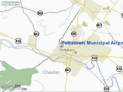
Pottstown Municipal Airport (FAA LID: N47) is a public use airport located in Montgomery County, Pennsylvania, United States. It is owned by the Borough of Pottstown and located two nautical miles (3.7 km) northwest of Pottstown's central business district.
TNT Air, Inc offers regular fixed base operator (FBO) services, as well as flight training. Since 2004, the airport hosts an Annual Airport Community Day to raise awareness of general aviation in its local communities. History
In 1946 John Basco and Charles Novack purchased the land now occupied by the airport. Construction of the buildings began a year later, in 1947, and an Open House was held on September 26, 1948. The airport was originally referred to as Stowe Airport or Basco's Airport. A 2,700-foot (820 m)-long runway was built in 1961, and a parallel taxiway was built in 1965. During the 1980s a business park was added.
As part of the federal Airport Improvement Program, the airport began multiple projects over the last few years. In 2003 a new hangar was completed. The fuel farm tanks were refinished in December 2005. The apron and taxiway was repaved in the spring of 2007.
Facilities and aircraft
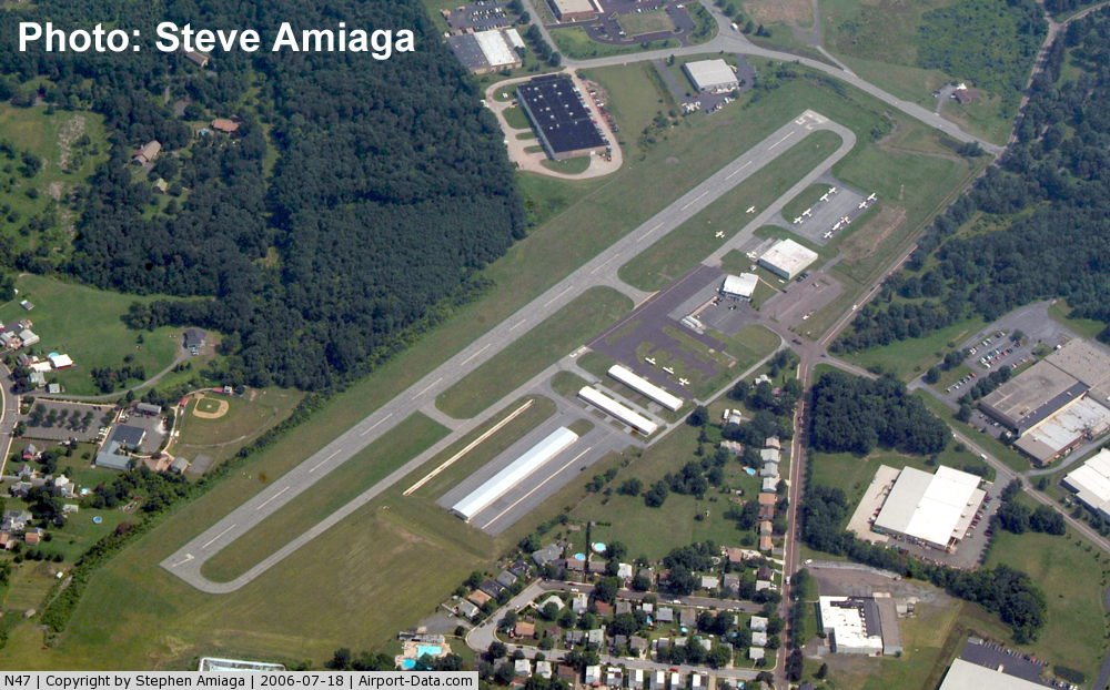
Pottstown Municipal Airport covers an area of 63 acres (25 ha) at an elevation of 256 feet (78 m) above mean sea level. It has one asphalt paved runway designated 8/26 which measures 2,704 by 75 feet (824 x 23 m).
For the 12-month period ending September 9, 2008, the airport had 24,687 aircraft operations, an average of 67 per day: 96% general aviation, 4% air taxi and <1% military. At that time there were 62 aircraft based at this airport: 97% single-engine and 3% multi-engine.
The above content comes from Wikipedia and is published under free licenses – click here to read more.
 |
(Click on the photo to enlarge) |
Location & QuickFacts
| FAA Information Effective: | 2008-09-25 |
| Airport Identifier: | N47 |
| Airport Status: | Operational |
| Longitude/Latitude: | 075-40-15.0710W/40-15-37.4430N
-75.670853/40.260401 (Estimated) |
| Elevation: | 256 ft / 78.03 m (Surveyed) |
| Land: | 63 acres |
| From nearest city: | 2 nautical miles NW of Pottstown, PA |
| Location: | Montgomery County, PA |
| Magnetic Variation: | 09W (1965) |
Owner & Manager
| Ownership: | Publicly owned |
| Owner: | Borough Of Pottstown |
| Address: | 100 E High St
Pottstown, PA 19464 |
| Phone number: | 610-970-6515 |
| Manager: | Angela Noetzel |
| Address: | 1149 Glasgow St
Pottstown, PA 19464 |
| Phone number: | 610-327-9464 |
Airport Operations and Facilities
| Airport Use: | Open to public |
| Wind indicator: | Yes |
| Segmented Circle: | Yes |
| Control Tower: | No |
| Lighting Schedule: | DUSK-DAWN
ACTVT PAPI RY 08; VASI RY 26; REIL RYS 08 & 26 - CTAF. |
| Beacon Color: | Clear-Green (lighted land airport) |
| Landing fee charge: | No |
| Sectional chart: | New York |
| Region: | AEA - Eastern |
| Boundary ARTCC: | ZNY - New York |
| Tie-in FSS: | IPT - Williamsport |
| FSS on Airport: | No |
| FSS Toll Free: | 1-800-WX-BRIEF |
| NOTAMs Facility: | IPT (NOTAM-d service avaliable) |
| Federal Agreements: | NGY |
Airport Communications
| CTAF: | 122.800 |
| Unicom: | 122.800 |
Airport Services
| Fuel available: | 100LLA |
| Airframe Repair: | MAJOR |
| Power Plant Repair: | MAJOR |
| Bottled Oxygen: | NONE |
| Bulk Oxygen: | NONE |
Runway Information
Runway 08/26
| Dimension: | 2704 x 75 ft / 824.2 x 22.9 m |
| Surface: | ASPH, Good Condition |
| Weight Limit: | Single wheel: 12000 lbs. |
| Edge Lights: | Medium |
| |
Runway 08 |
Runway 26 |
| Longitude: | 075-40-31.1150W | 075-39-58.9810W |
| Latitude: | 40-15-32.2860N | 40-15-42.6780N |
| Elevation: | 254.00 ft | 244.00 ft |
| Alignment: | 67 | 127 |
| Traffic Pattern: | Left | Left |
| Markings: | Basic, Good Condition | Basic, Good Condition |
| Crossing Height: | 0.00 ft | 20.00 ft |
| VASI: | 2-light PAPI on left side
RY 07 PAPI OTS INDEFLY. | 2-box on left side |
| Visual Glide Angle: | 0.00° | 3.00° |
| Runway End Identifier: | Yes | Yes |
| Obstruction: | 38 ft tree, 579.0 ft from runway, 155 ft left of centerline, 9:1 slope to clear
RY 7 HAS 6FT BRUSH, 155 FT FM RY END, 117 FT L. | 41 ft tree, 1169.0 ft from runway, 20 ft left of centerline, 23:1 slope to clear
RY 25 HAS 6FT BRUSH, 110 FT FM RY END, ACROSS WIDTH OF PRIMARY SFC. |
|
Radio Navigation Aids
| ID |
Type |
Name |
Ch |
Freq |
Var |
Dist |
| ING | NDB | Ambler | | 275.00 | 11W | 19.5 nm |
| UKT | NDB | Quakertown | | 208.00 | 12W | 19.8 nm |
| NXX | NDB | Willow Grove | | 388.00 | 12W | 24.5 nm |
| DYL | NDB | Doylestown | | 237.00 | 10W | 25.6 nm |
| LQX | NDB | Carbon | | 339.00 | 12W | 33.4 nm |
| BZJ | NDB | Bellgrove | | 328.00 | 10W | 41.8 nm |
| HXM | NDB | Humbolt | | 366.00 | 10W | 46.2 nm |
| APG | NDB | Aberdeen | | 349.00 | 11W | 48.0 nm |
| NXX | TACAN | Willow Grove | 061X | | 10W | 24.4 nm |
| PNE | VOR | North Philadelphia | | 112.00 | 10W | 32.2 nm |
| HZL | VOR | Hazleton | | 109.40 | 09W | 47.7 nm |
| CKZ | VOR/DME | Pennridge | 025Y | 108.85 | 12W | 19.2 nm |
| ETX | VOR/DME | East Texas | 039X | 110.20 | 09W | 19.3 nm |
| ARD | VOR/DME | Yardley | 019X | 108.20 | 10W | 35.0 nm |
| SBJ | VOR/DME | Solberg | 076X | 112.90 | 10W | 46.7 nm |
| PTW | VORTAC | Pottstown | 112X | 116.50 | 09W | 5.6 nm |
| MXE | VORTAC | Modena | 079X | 113.20 | 09W | 20.6 nm |
| LRP | VORTAC | Lancaster | 120X | 117.30 | 09W | 29.7 nm |
| FJC | VORTAC | Allentown | 122X | 117.50 | 10W | 29.7 nm |
| DQO | VORTAC | Dupont | 087X | 114.00 | 10W | 35.1 nm |
| OOD | VORTAC | Woodstown | 075X | 112.80 | 10W | 41.2 nm |
| RAV | VORTAC | Ravine | 093X | 114.60 | 11W | 46.0 nm |
| PHL | VOT | Philadelphia Intl | | 109.80 | | 30.6 nm |
Remarks
- RY 25 DEP CLIMB ON RY HEADING TO 1000 FT BEFORE STARTING TURN.
- DEER & SEAGULLS ON & INVOF ARPT.
- FOR SVC AFTER HRS CNTC 610-858-7453
- BUILT PRIOR TO 1959.
Images and information placed above are from
http://www.airport-data.com/airport/N47/
We thank them for the data!
| General Info
|
| Country |
United States
|
| State |
PENNSYLVANIA
|
| FAA ID |
N47
|
| Latitude |
40-15-37.443N
|
| Longitude |
075-40-15.071W
|
| Elevation |
256 feet
|
| Near City |
POTTSTOWN
|
We don't guarantee the information is fresh and accurate. The data may
be wrong or outdated.
For more up-to-date information please refer to other sources.
|
|