|
|
Pottstown Limerick Airport |
Heritage Field
(Pottstown Limerick Airport) |
| IATA: PTW – ICAO: KPTW – FAA LID: PTW |
| Summary |
| Airport type |
Public use |
| Owner |
Exelon Generation Company, LLC |
| Serves |
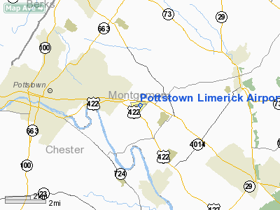
Pottstown, Pennsylvania |
| Elevation AMSL |
309 ft / 94 m |
| Coordinates |
40°14′22″N 075°33′24″W / 40.23944°N 75.55667°W / 40.23944; -75.55667 |
| Runways |
| Direction |
Length |
Surface |
| ft |
m |
| 10/28 |
3,371 |
1,027 |
Asphalt |
| Statistics (2008) |
| Aircraft operations |
37,217 |
| Based aircraft |
98 |
| Source: Federal Aviation Administration |
Heritage Field (Pottstown Limerick Airport) (IATA: PTW, ICAO: KPTW, FAA LID: PTW) is a public use airport located three nautical miles (6 km) east of the central business district of Pottstown, in Montgomery County, Pennsylvania, United States. The airport is privately owned by the Exelon Generation Company which also owns the nearby Limerick Generating Station (power plant).
Penn Airways is a fixed base operator located on the field.
Pottstown Limerick Airport was renamed to Heritage Field in late 2009 and is now referred as that name on the local UNICOM.
Facilities and aircraft
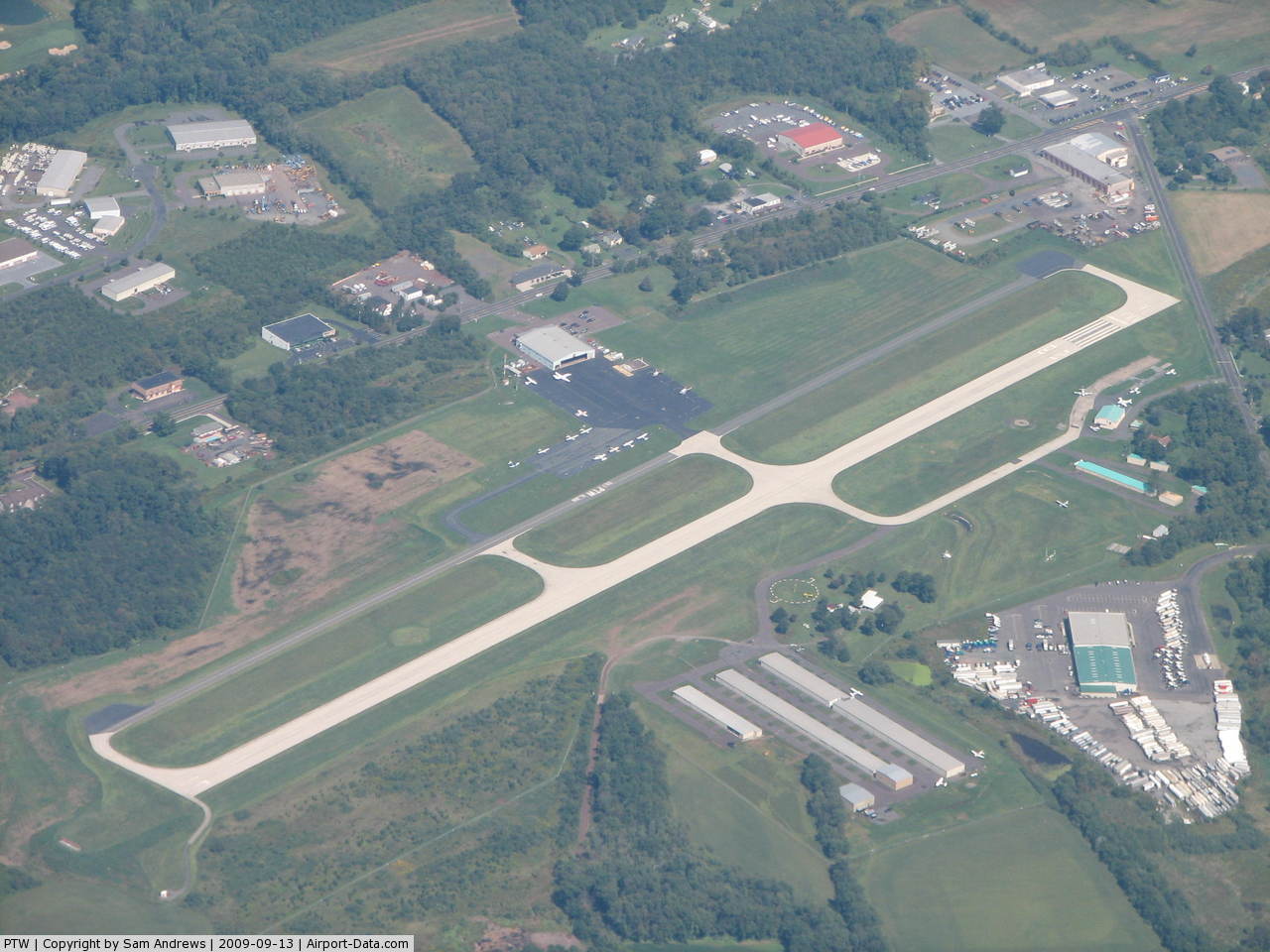
Heritage Field covers an area of 220 acres (89 ha) at an elevation of 309 feet (94 m) above mean sea level. It has one asphalt paved runway designated 10/28 which measures 3,371 by 75 feet (1,027 x 23 m).
For the 12-month period ending June 12, 2008, the airport had 37,217 aircraft operations, an average of 101 per day: 82% general aviation, 17% air taxi and <1% military. At that time there were 98 aircraft based at this airport: 86% single-engine, 8% multi-engine, 2% jet, 2% helicopter, 1% glider, 1% ultralight.
The above content comes from Wikipedia and is published under free licenses – click here to read more.
 |
(Click on the photo to enlarge) |
Location & QuickFacts
| FAA Information Effective: | 2008-09-25 |
| Airport Identifier: | PTW |
| Airport Status: | Operational |
| Longitude/Latitude: | 075-33-24.1100W/40-14-22.4300N
-75.556697/40.239564 (Estimated) |
| Elevation: | 309 ft / 94.18 m (Surveyed) |
| Land: | 220 acres |
| From nearest city: | 3 nautical miles E of Pottstown, PA |
| Location: | Montgomery County, PA |
| Magnetic Variation: | 12W (1990) |
Owner & Manager
| Ownership: | Privately owned |
| Owner: | Exelon Generation Company Llc |
| Address: | Lgs Sanatoga Road
Pottstown, PA 19464 |
| Phone number: | 610-718-3075 |
| Manager: | Michael D'aries |
| Address: | 3310 West Ridge Pike
Pottstown, PA 19464 |
| Phone number: | 610-495-7000 |
Airport Operations and Facilities
| Airport Use: | Open to public |
| Wind indicator: | Yes |
| Segmented Circle: | Yes |
| Control Tower: | No |
| Lighting Schedule: | DUSK-DAWN |
| Beacon Color: | Clear-Green (lighted land airport) |
| Landing fee charge: | Yes |
| Sectional chart: | New York |
| Region: | AEA - Eastern |
| Boundary ARTCC: | ZNY - New York |
| Tie-in FSS: | IPT - Williamsport |
| FSS on Airport: | No |
| FSS Toll Free: | 1-800-WX-BRIEF |
| NOTAMs Facility: | PTW (NOTAM-d service avaliable) |
| Federal Agreements: | NMY |
Airport Communications
| CTAF: | 122.700 |
| Unicom: | 122.700 |
Airport Services
| Fuel available: | 100LLA |
| Airframe Repair: | MAJOR |
| Power Plant Repair: | MAJOR |
| Bottled Oxygen: | NONE |
| Bulk Oxygen: | NONE |
Runway Information
Runway 10/28
| Dimension: | 3371 x 75 ft / 1027.5 x 22.9 m |
| Surface: | ASPH, Good Condition |
| Edge Lights: | Medium |
| |
Runway 10 |
Runway 28 |
| Longitude: | 075-33-45.7300W | 075-33-02.4900W |
| Latitude: | 40-14-20.7200N | 40-14-24.1400N |
| Elevation: | 307.00 ft | 303.00 ft |
| Alignment: | 84 | 127 |
| ILS Type: | | LOCALIZER
|
| Traffic Pattern: | Left | Right |
| Markings: | Basic, Fair Condition | Non-precision instrument, Fair Condition |
| Crossing Height: | 45.00 ft | 45.00 ft |
| Displaced threshold: | 0.00 ft | 200.00 ft |
| VASI: | 2-light PAPI on left side | 2-light PAPI on left side |
| Visual Glide Angle: | 3.00° | 3.00° |
| Runway End Identifier: | Yes | Yes |
| Obstruction: | 39 ft brush, 985.0 ft from runway, 301 ft left of centerline, 20:1 slope to clear | 35 ft trees, 580.0 ft from runway, 283 ft right of centerline, 10:1 slope to clear
RY 28 APCH RATIO 22:1 TO DSPLCD THLD.
+10 FT ROAD 0-200 FT FM THLD. +6 FT SIGN 214 FT LEFT OF THLD. |
|
Radio Navigation Aids
| ID |
Type |
Name |
Ch |
Freq |
Var |
Dist |
| ING | NDB | Ambler | | 275.00 | 11W | 14.2 nm |
| UKT | NDB | Quakertown | | 208.00 | 12W | 16.3 nm |
| NXX | NDB | Willow Grove | | 388.00 | 12W | 19.1 nm |
| DYL | NDB | Doylestown | | 237.00 | 10W | 20.7 nm |
| LQX | NDB | Carbon | | 339.00 | 12W | 35.6 nm |
| BZJ | NDB | Bellgrove | | 328.00 | 10W | 47.1 nm |
| HXM | NDB | Humbolt | | 366.00 | 10W | 49.3 nm |
| APG | NDB | Aberdeen | | 349.00 | 11W | 49.4 nm |
| NXX | TACAN | Willow Grove | 061X | | 10W | 19.0 nm |
| PNE | VOR | North Philadelphia | | 112.00 | 10W | 26.9 nm |
| CKZ | VOR/DME | Pennridge | 025Y | 108.85 | 12W | 15.3 nm |
| ETX | VOR/DME | East Texas | 039X | 110.20 | 09W | 21.3 nm |
| ARD | VOR/DME | Yardley | 019X | 108.20 | 10W | 29.8 nm |
| SBJ | VOR/DME | Solberg | 076X | 112.90 | 10W | 42.6 nm |
| BWZ | VOR/DME | Broadway | 089X | 114.20 | 11W | 47.5 nm |
| PTW | VORTAC | Pottstown | 112X | 116.50 | 09W | 1.1 nm |
| MXE | VORTAC | Modena | 079X | 113.20 | 09W | 20.0 nm |
| FJC | VORTAC | Allentown | 122X | 117.50 | 10W | 29.6 nm |
| DQO | VORTAC | Dupont | 087X | 114.00 | 10W | 33.8 nm |
| LRP | VORTAC | Lancaster | 120X | 117.30 | 09W | 34.5 nm |
| OOD | VORTAC | Woodstown | 075X | 112.80 | 10W | 38.1 nm |
| GXU | VORTAC | Mc Guire | 043X | 110.60 | 11W | 46.3 nm |
| RBV | VORTAC | Robbinsville | 085X | 113.80 | 10W | 48.8 nm |
| PHL | VOT | Philadelphia Intl | | 109.80 | | 26.4 nm |
Remarks
- LGTD & MKD 507' AGL (769' MSL) STACK 6000' W OF RY 10.
- BIRDS & DEER ON & INVOF ARPT.
- ARPT PERMLY CLSD TO ACFT 13500 LBS & OVER.
- EXISTED PRIOR TO 1959.
Images and information placed above are from
http://www.airport-data.com/airport/PTW/
We thank them for the data!
| General Info
|
| Country |
United States
|
| State |
PENNSYLVANIA
|
| FAA ID |
PTW
|
| Latitude |
40-14-22.458N
|
| Longitude |
075-33-23.851W
|
| Elevation |
309 feet
|
| Near City |
POTTSTOWN
|
We don't guarantee the information is fresh and accurate. The data may
be wrong or outdated.
For more up-to-date information please refer to other sources.
|
|