 |
|
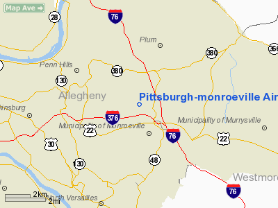
Pittsburgh-monroeville Airport |
Pittsburgh-Monroeville Airport
Harold W. Brown Memorial Airfield |
| IATA: none – ICAO: none – FAA LID: 4G0 |
| Summary |
| Airport type |
Public |
| Owner |
Helen M. Brown |
| Serves |
Monroeville, Pennsylvania |
| Elevation AMSL |
1,187 ft / 362 m |
| Coordinates |
40°27′08″N 079°46′29″W / 40.45222°N 79.77472°W / 40.45222; -79.77472 |
| Runways |
| Direction |
Length |
Surface |
| ft |
m |
| 5/23 |
2,280 |
695 |
Asphalt |
| Statistics (2007) |
| Aircraft operations |
5,709 |
| Based aircraft |
17 |
| Source: Federal Aviation Administration |
Pittsburgh-Monroeville Airport (FAA LID: 4G0) is a public-use airport located one nautical mile (1.8 km) north of the central business district of Monroeville, in Allegheny County, Pennsylvania, United States. The airport is privately owned by Helen M. Brown and is also known as the Harold W. Brown Memorial Field.
The airport no longer offers aviation fuel for sale, but 2,000 planes land and take off at the airport every year, according to Weible. Pilots pay $3 on the honor system to defray the expenses of mowing the grass and maintaining the runway for an overnight stay.
The airport also hosts a gathering every other year for the Aero Club of Pittsburgh. The airport buildings also serve as the meeting place for Cadet Squad 604 of the Civil Air Patrol.
The airfield was used as a filming location in a pivotal scene in the 1978 horror film Dawn of the Dead. History
Harold and Helen Bohinski Brown opened Pittsburgh Monroeville Airport in 1948. Before it closed in the early 1970s, it was noted for its air shows that attracted hundreds of spectators and for handling the air mail for the Wilmerding Post Office.
Pittsburgh-Monroeville Airport currently houses sixteen privately-owned planes in several hangars, down from 74 in 1970, and 112 between 1952 and 1958. Its manager for the past eighteen years, Raymond J. Weible erected a sign along Logans Ferry Road designating the field as Harold W. Brown Memorial Field. "Mrs. Brown is proud she and her late husband, a pilot himself, worked hard to make it a first-class facility in 1948 for small planes to land, flight instruction, and a place to hangar residents’ planes."
Facilities and aircraft
Pittsburgh-Monroeville Airport covers an area of 63 acres (25 ha) at an elevation of 1,187 feet (362 m) above mean sea level. It has one runway designated 5/23 with a 2,280 by 28 ft (695 x 9 m) asphalt surface. For the 12-month period ending June 12, 2007, the airport had 5,709 aircraft operations, an average of 15 per day: 99.8% general aviation and <0.2% military. At that time there were 17 aircraft based at this airport: 94% single-engine and 6% ultralight.
The above content comes from Wikipedia and is published under free licenses – click here to read more.
Location & QuickFacts
| FAA Information Effective: | 2008-09-25 |
| Airport Identifier: | 4G0 |
| Airport Status: | Operational |
| Longitude/Latitude: | 079-46-29.1680W/40-27-08.2460N
-79.774769/40.452291 (Estimated) |
| Elevation: | 1187 ft / 361.80 m (Estimated) |
| Land: | 63 acres |
| From nearest city: | 1 nautical miles N of Monroeville, PA |
| Location: | Allegheny County, PA |
| Magnetic Variation: | 08W (1985) |
Owner & Manager
| Ownership: | Privately owned |
| Owner: | Helen M. Brown |
| Address: | 2388 Tillbrook Dr
Monroeville, PA 15146 |
| Phone number: | 412-372-7342 |
| Manager: | Ray Weible |
| Address: | 122 Carrie Ann Dr
New Kensington, PA 15068 |
| Phone number: | 412-372-2256
ALSO (412) 380-7059 |
Airport Operations and Facilities
| Airport Use: | Open to public |
| Wind indicator: | Yes |
| Segmented Circle: | Yes |
| Control Tower: | No |
| Landing fee charge: | No |
| Sectional chart: | Detroit |
| Region: | AEA - Eastern |
| Traffic Pattern Alt: | 800 ft |
| Boundary ARTCC: | ZOB - Cleveland |
| Tie-in FSS: | AOO - Altoona |
| FSS on Airport: | No |
| FSS Toll Free: | 1-800-WX-BRIEF |
| NOTAMs Facility: | AOO (NOTAM-d service avaliable) |
Airport Communications
Airport Services
| Airframe Repair: | MINOR |
| Power Plant Repair: | MINOR |
| Bottled Oxygen: | NONE |
| Bulk Oxygen: | NONE |
Runway Information
Runway 05/23
| Dimension: | 2280 x 28 ft / 694.9 x 8.5 m |
| Surface: | ASPH, Poor Condition
RY 05/23 EXTENSIVE CRACKS AND UNEVEN PATCHES. |
| |
Runway 05 |
Runway 23 |
| Traffic Pattern: | Left | Right |
| Markings: | Basic, Fair Condition | Basic, Fair Condition |
| Obstruction: | 33 ft trees, 318.0 ft from runway, 78 ft right of centerline, 3:1 slope to clear
RY 05 HAS +25 FT TREES 54 FT FM THLD 117 FT RT, +37 FT TREES 94 FT FM THLD, 109 FT RT AND +30 FT TREES 142 FT FM THLD, 71 FT RT. +7 FT TREES 61 FT FM THLD 66 FT LEFT. | , 50:1 slope to clear |
|
Radio Navigation Aids
| ID |
Type |
Name |
Ch |
Freq |
Var |
Dist |
| MKP | NDB | Mc Keesport | | 287.00 | 07W | 5.8 nm |
| BHU | NDB | Benje | | 382.00 | 07W | 23.5 nm |
| PNU | NDB | Washington County | | 255.00 | 08W | 25.7 nm |
| INP | NDB | Indiana | | 242.00 | 08W | 34.1 nm |
| VV | NDB | Camor | | 299.00 | 08W | 34.3 nm |
| UCP | NDB | Castle | | 272.00 | 09W | 45.0 nm |
| SYS | NDB | Stoystown | | 209.00 | 08W | 45.1 nm |
| AGC | VOR/DME | Allegheny | 037X | 110.00 | 09W | 16.0 nm |
| HLG | VOR/DME | Wheeling | 059X | 112.20 | 07W | 38.2 nm |
| CIP | VOR/DME | Clarion | 076X | 112.90 | 06W | 44.1 nm |
| REC | VOR/DME | Revloc | 043X | 110.60 | 09W | 47.3 nm |
| MMJ | VORTAC | Montour | 057X | 112.00 | 08W | 19.3 nm |
| EWC | VORTAC | Ellwood City | 105X | 115.80 | 08W | 30.0 nm |
| IHD | VORTAC | Indian Head | 019X | 108.20 | 06W | 34.5 nm |
| JST | VORTAC | Johnstown | 077X | 113.00 | 06W | 43.8 nm |
Remarks
- DEER ON AND IN VICINITY OF AIRPORT
- VFR OPERNS ONLY.
Images and information placed above are from
http://www.airport-data.com/airport/4G0/
We thank them for the data!
| General Info
|
| Country |
United States
|
| State |
PENNSYLVANIA
|
| FAA ID |
4G0
|
| Latitude |
40-27-08.246N
|
| Longitude |
079-46-29.168W
|
| Elevation |
1187 feet
|
| Near City |
MONROEVILLE
|
We don't guarantee the information is fresh and accurate. The data may
be wrong or outdated.
For more up-to-date information please refer to other sources.
|
|


