 |
|
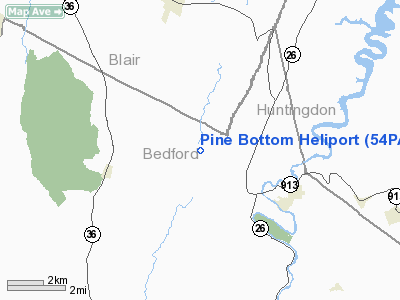
Location & QuickFacts
| FAA Information Effective: | 2008-09-25 |
| Airport Identifier: | 54PA |
| Airport Status: | Operational |
| Longitude/Latitude: | 078-18-19.1100W/40-14-10.4200N
-78.305308/40.236228 (Estimated) |
| Elevation: | 1504 ft / 458.42 m () |
| Land: | 1504 acres |
| From nearest city: | 4 nautical miles S of Martinsburg, PA |
| Location: | Bedford County, PA |
| Magnetic Variation: | () |
Owner & Manager
| Ownership: | Privately owned |
| Owner: | Daniel Lipko |
| Address: | 1702 Pulpit Rd
Martinsburg, PA 16662 |
| Phone number: | 814-793-4548 |
| Manager: | Daniel Lipko |
| Address: | 1702 Pulpit Rd
Martinsburg, PA 16662 |
| Phone number: | 814-793-4548 |
Airport Operations and Facilities
| Airport Use: | Private |
| Wind indicator: | Yes |
| Control Tower: | No |
| Sectional chart: | Detroit |
| Region: | AEA - Eastern |
| Boundary ARTCC: | ZOB - Cleveland |
| Tie-in FSS: | AOO - Altoona |
| FSS Toll Free: | 1-800-WX-BRIEF |
Runway Information
Helipad H1
| Dimension: | 150 x 150 ft / 45.7 x 45.7 m |
| Surface: | TURF, |
| |
Runway H1 |
Runway |
| Traffic Pattern: | Left | Left |
|
Radio Navigation Aids
| ID |
Type |
Name |
Ch |
Freq |
Var |
Dist |
| SYS | NDB | Stoystown | | 209.00 | 08W | 29.5 nm |
| RV | NDB | Stroh | | 407.00 | 10W | 35.2 nm |
| CBE | NDB | Cumberland | | 317.00 | 07W | 40.8 nm |
| INP | NDB | Indiana | | 242.00 | 08W | 42.2 nm |
| BHU | NDB | Benje | | 382.00 | 07W | 45.1 nm |
| AOO | VOR | Altoona | | 108.80 | 07W | 5.4 nm |
| HGR | VOR | Hagerstown | | 109.80 | 07W | 38.4 nm |
| REC | VOR/DME | Revloc | 043X | 110.60 | 09W | 27.5 nm |
| GRV | VOR/DME | Grantsville | 070X | 112.30 | 06W | 49.9 nm |
| THS | VORTAC | St Thomas | 097X | 115.00 | 07W | 24.4 nm |
| JST | VORTAC | Johnstown | 077X | 113.00 | 06W | 24.7 nm |
| TON | VORTAC | Tyrone | 096X | 114.90 | 07W | 30.0 nm |
| PSB | VORTAC | Philipsburg | 102X | 115.50 | 10W | 43.3 nm |
Remarks
- PRVDD VFR/PVT USE; ALL APCH DEP ROUTES USE TOUCHDOWN PAD AS CENTER OF COMPASS ROSE; TAKE-OFF/LANDING AREA MARKED; AND A WIND INDICATOR MAINTAINED.
Images and information placed above are from
http://www.airport-data.com/airport/54PA/
We thank them for the data!
| General Info
|
| Country |
United States
|
| State |
PENNSYLVANIA
|
| FAA ID |
54PA
|
| Latitude |
39-55-30.352N
|
| Longitude |
076-53-58.909W
|
| Elevation |
500 feet
|
| Near City |
THOMASVILLE
|
We don't guarantee the information is fresh and accurate. The data may
be wrong or outdated.
For more up-to-date information please refer to other sources.
|
|


