 |
|
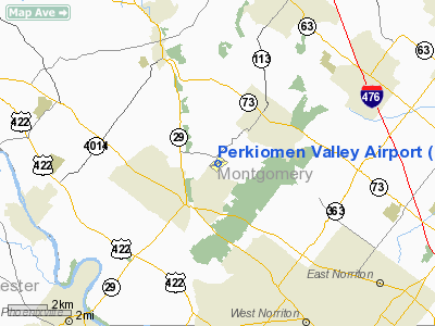
| Perkiomen Valley Airport |
| IATA: none – ICAO: none – FAA LID: N10 |
| Summary |
| Airport type |
Public |
| Owner |
Estate of Lane R. Jubb |
| Serves |
Collegeville, Pennsylvania |
| Elevation AMSL |
277 ft / 84 m |
| Coordinates |
40°12′15″N 075°25′49″W / 40.20417°N 75.43028°W / 40.20417; -75.43028 |
| Runways |
| Direction |
Length |
Surface |
| ft |
m |
| 9/27 |
2,880 |
878 |
Asphalt |
| Statistics (2008) |
| Aircraft operations |
24,340 |
| Based aircraft |
51 |
| Source: Federal Aviation Administration |
Perkiomen Valley Airport (FAA LID: N10) is a public use airport located two nautical miles (3.7 km) northeast of the central business district of Collegeville, in Montgomery County, Pennsylvania, United States. It is privately owned by the estate of Lane R. Jubb. The airport was opened on March 1, 1938.
Facilities and aircraft
Perkiomen Valley Airport covers an area of 60 acres (24 ha) at an elevation of 277 feet (84 m) above mean sea level. It has one runway designated 9/27 with an asphalt surface measuring 2,880 by 40 feet (878 x 12 m).
Valley Forge Aviation is a fixed base operator (FBO) located on the field.
For the 12-month period ending November 4, 2008, the airport had 24,340 aircraft operations, an average of 66 per day: 99.8% general aviation and 0.2% military. At that time there were 51 aircraft based at this airport: 98% single-engine and 2% multi-engine.
The above content comes from Wikipedia and is published under free licenses – click here to read more.
Location & QuickFacts
| FAA Information Effective: | 2008-09-25 |
| Airport Identifier: | N10 |
| Airport Status: | Operational |
| Longitude/Latitude: | 075-25-48.9470W/40-12-14.5740N
-75.430263/40.204048 (Estimated) |
| Elevation: | 277 ft / 84.43 m (Estimated) |
| Land: | 60 acres |
| From nearest city: | 2 nautical miles NE of Collegeville, PA |
| Location: | Montgomery County, PA |
| Magnetic Variation: | 12W (2005) |
Owner & Manager
| Ownership: | Privately owned |
| Owner: | Estate Of Lane R. Jubb |
| Address: | 767 Collegeville Rd
Collegeville, PA 19426 |
| Phone number: | 610-666-5135 |
| Manager: | Abe Jones |
| Address: | 767 Collegeville Rd
Collegeville, PA 19426 |
| Phone number: | 610-489-6011 |
Airport Operations and Facilities
| Airport Use: | Open to public |
| Wind indicator: | Yes |
| Segmented Circle: | No |
| Control Tower: | No |
| Lighting Schedule: | RDO-CTL
ACTVT LIRL RY 09/27 & ROTG BCN - CTAF. |
| Beacon Color: | Clear-Green (lighted land airport) |
| Landing fee charge: | No |
| Sectional chart: | New York |
| Region: | AEA - Eastern |
| Boundary ARTCC: | ZNY - New York |
| Tie-in FSS: | IPT - Williamsport |
| FSS on Airport: | No |
| FSS Toll Free: | 1-800-WX-BRIEF |
| NOTAMs Facility: | IPT (NOTAM-d service avaliable) |
| Federal Agreements: | N |
Airport Communications
| CTAF: | 122.800 |
| Unicom: | 122.800 |
Airport Services
| Fuel available: | 100LL |
| Bottled Oxygen: | NONE |
| Bulk Oxygen: | NONE |
Runway Information
Runway 09/27
| Dimension: | 2880 x 40 ft / 877.8 x 12.2 m |
| Surface: | ASPH, Fair Condition |
| Weight Limit: | Single wheel: 125000 lbs. |
| Edge Lights: | Non-standard lighting system
RY 09/27 NSTD LIRL. |
| |
Runway 09 |
Runway 27 |
| Longitude: | 075-26-06.9530W | 075-25-30.8740W |
| Latitude: | 40-12-11.2280N | 40-12-17.9120N |
| Elevation: | 245.00 ft | 273.00 ft |
| Alignment: | 76 | 127 |
| Traffic Pattern: | Left | Left |
| Markings: | Nonstandard, Good Condition
RY 09/27 NSTD BSC MKGS, ARROWS SMALL AND MISALIGNED, DOUBLE THRESHOLD BAR AND SMALL NUMBERS. | Nonstandard, Good Condition |
| Displaced threshold: | 420.00 ft
RY 09 DSPLCD THLD LTS 150 FT DOWN RY FM THLD MARKING. | 370.00 ft
RY 27 DSPLCD THR MARKED WITH 2 PARALLEL WHITE LINES; LGTD WITH 4 RED & GREEN LGTS EACH SIDE OF RY. |
| Obstruction: | 48 ft trees, 273.0 ft from runway, 186 ft right of centerline, 1:1 slope to clear
RY 09 APCH RATIO 14:1 TO DSPLCD THLD.
RWY 09 +20 FT ROAD AT THLD 37 FT L TO 250 FT R. - MULTIPLE TREES +58 IN OFS - TLN 70 FT FM RWY CLN EXTND 700 FT FRM RWY END | 39 ft trees, 452.0 ft from runway, 192 ft left of centerline, 6:1 slope to clear
RY 27 APCH RATIO 21:1 TO DSPLCD THLD.
RWY 27 +7 FT ROAD AT THLD 135 FT R TO 192 FT L. - TREES +50 21 FT FRM RWY END |
|
Radio Navigation Aids
| ID |
Type |
Name |
Ch |
Freq |
Var |
Dist |
| ING | NDB | Ambler | | 275.00 | 11W | 8.2 nm |
| NXX | NDB | Willow Grove | | 388.00 | 12W | 13.1 nm |
| UKT | NDB | Quakertown | | 208.00 | 12W | 14.6 nm |
| DYL | NDB | Doylestown | | 237.00 | 10W | 16.2 nm |
| LQX | NDB | Carbon | | 339.00 | 12W | 39.5 nm |
| RNB | NDB | Rainbow | | 363.00 | 11W | 49.2 nm |
| NXX | TACAN | Willow Grove | 061X | | 10W | 13.0 nm |
| PNE | VOR | North Philadelphia | | 112.00 | 10W | 20.7 nm |
| CKZ | VOR/DME | Pennridge | 025Y | 108.85 | 12W | 13.0 nm |
| ARD | VOR/DME | Yardley | 019X | 108.20 | 10W | 24.2 nm |
| ETX | VOR/DME | East Texas | 039X | 110.20 | 09W | 25.5 nm |
| SBJ | VOR/DME | Solberg | 076X | 112.90 | 10W | 38.9 nm |
| BWZ | VOR/DME | Broadway | 089X | 114.20 | 11W | 45.3 nm |
| PTW | VORTAC | Pottstown | 112X | 116.50 | 09W | 6.1 nm |
| MXE | VORTAC | Modena | 079X | 113.20 | 09W | 20.4 nm |
| FJC | VORTAC | Allentown | 122X | 117.50 | 10W | 31.4 nm |
| DQO | VORTAC | Dupont | 087X | 114.00 | 10W | 32.6 nm |
| OOD | VORTAC | Woodstown | 075X | 112.80 | 10W | 34.6 nm |
| LRP | VORTAC | Lancaster | 120X | 117.30 | 09W | 39.9 nm |
| GXU | VORTAC | Mc Guire | 043X | 110.60 | 11W | 40.1 nm |
| RBV | VORTAC | Robbinsville | 085X | 113.80 | 10W | 42.9 nm |
| VCN | VORTAC | Cedar Lake | 099X | 115.20 | 10W | 45.4 nm |
| PHL | VOT | Philadelphia Intl | | 109.80 | | 21.8 nm |
Remarks
- EXISTED PRIOR TO MAY 15 1959.
Images and information placed above are from
http://www.airport-data.com/airport/N10/
We thank them for the data!
| General Info
|
| Country |
United States
|
| State |
PENNSYLVANIA
|
| FAA ID |
N10
|
| Latitude |
40-12-14.574N
|
| Longitude |
075-25-48.947W
|
| Elevation |
277 feet
|
| Near City |
COLLEGEVILLE
|
We don't guarantee the information is fresh and accurate. The data may
be wrong or outdated.
For more up-to-date information please refer to other sources.
|
|


