 |
|
| Pennridge Airport |
| IATA: none – ICAO: KCKZ – FAA LID: CKZ |
| Summary |
| Airport type |
Public |
| Owner |
Pennridge Development Ent. Inc. |
| Serves |
Perkasie, Pennsylvania |
| Location |
East Rockhill Township |
| Elevation AMSL |
568 ft / 173 m |
| Coordinates |
40°23′21″N 075°17′26″W / 40.38917°N 75.29056°W / 40.38917; -75.29056 |
| Runways |
| Direction |
Length |
Surface |
| ft |
m |
| 8/26 |
4,215 |
1,285 |
Asphalt |
| Statistics (2008) |
| Aircraft operations |
29,635 |
| Based aircraft |
42 |
| Source: Federal Aviation Administration |
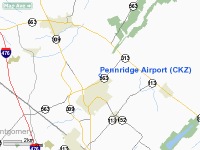
Pennridge Airport (ICAO: KCKZ, FAA LID: CKZ, formerly N70) is a public use airport located one nautical mile (1.85 km) north of the central business district of Perkasie, a borough in Bucks County, Pennsylvania, United States. It is privately owned by Pennridge Development Ent., Inc. The airport is situated in East Rockhill Township.
The airport is located on top of a ridge and is surrounded on every side by trees. Although the daily operations are under 100 takeoffs/landings, it is the largest privately owned airport between Philadelphia and Allentown.
Although most U.S. airports use the same three-letter location identifier for the FAA and IATA, this airport is assigned CKZ by the FAA but has no designation from the IATA (which assigned CKZ to Canakkale Airport in Canakkale, Turkey). History
The airport has been in place in Perkasie since January 23, 1966, but when Byrant Aviation took over in 1968 the activity increased rapidly. In 1981, Andrew Deutsch, a nearby resident, bought the airport to save it from turning into a housing development. For a brief period in the late 1980s, a landing fee of $5-6 was charged to pilots.
On November 1, 2008 John McCain made a stop at Pennridge Airport during his 2008 campaign.
Facilities and aircraft
Pennridge Airport covers an area of 270 acres (109 ha) at an elevation of 568 feet (173 m) above mean sea level. It has one runway designated 8/26 with an asphalt surface measuring 4,215 by 100 feet (1,285 x 30 m).
For the 12-month period ending November 25, 2008, the airport had 29,635 aircraft operations, an average of 81 per day: 99% general aviation and 1% military. At that time there were 42 aircraft based at this airport: 86% single-engine, 12% multi-engine and 2% jet.
The above content comes from Wikipedia and is published under free licenses – click here to read more.
Location & QuickFacts
| FAA Information Effective: | 2008-09-25 |
| Airport Identifier: | CKZ |
| Airport Status: | Operational |
| Longitude/Latitude: | 075-17-25.7330W/40-23-21.0710N
-75.290481/40.389186 (Estimated) |
| Elevation: | 568 ft / 173.13 m (Surveyed) |
| Land: | 270 acres |
| From nearest city: | 1 nautical miles N of Perkasie, PA |
| Location: | Bucks County, PA |
| Magnetic Variation: | 12W (2005) |
Owner & Manager
| Ownership: | Privately owned |
| Owner: | Pennridge Development Ent Inc |
| Address: | 1100 Ridge Road
Perkasie, PA 18944 |
| Phone number: | 215-257-0166 |
| Manager: | Jean Curry |
| Address: | 1100 N Ridge Road
Perkasie, PA 18944 |
| Phone number: | 215-257-0166 |
Airport Operations and Facilities
| Airport Use: | Open to public |
| Wind indicator: | Yes |
| Segmented Circle: | No |
| Control Tower: | No |
| Lighting Schedule: | DUSK-DAWN |
| Beacon Color: | Clear-Green (lighted land airport) |
| Landing fee charge: | No |
| Sectional chart: | New York |
| Region: | AEA - Eastern |
| Boundary ARTCC: | ZNY - New York |
| Tie-in FSS: | IPT - Williamsport |
| FSS on Airport: | No |
| FSS Toll Free: | 1-800-WX-BRIEF |
| NOTAMs Facility: | IPT (NOTAM-d service avaliable) |
Airport Communications
| CTAF: | 123.000 |
| Unicom: | 123.000 |
Airport Services
| Fuel available: | 100LLA |
| Airframe Repair: | MAJOR |
| Power Plant Repair: | MAJOR |
| Bottled Oxygen: | NONE |
| Bulk Oxygen: | NONE |
Runway Information
Runway 08/26
| Dimension: | 4215 x 100 ft / 1284.7 x 30.5 m |
| Surface: | ASPH, Fair Condition |
| Surface Treatment: | Porous Friction Course |
| Weight Limit: | Dual wheel: 26000 lbs. |
| Edge Lights: | Medium |
| |
Runway 08 |
Runway 26 |
| Longitude: | 075-17-51.2330W | 075-17-00.1500W |
| Latitude: | 40-23-13.8430N | 40-23-28.2900N |
| Elevation: | 520.00 ft | 568.00 ft |
| Alignment: | 70 | 127 |
| Traffic Pattern: | Left | Left |
| Markings: | Non-precision instrument, Good Condition | Non-precision instrument, Fair Condition |
| Crossing Height: | 21.00 ft | 21.00 ft |
| Displaced threshold: | 0.00 ft | 360.00 ft |
| VASI: | 2-box SAVASI on left side | 2-box SAVASI on left side |
| Visual Glide Angle: | 4.00° | 4.00° |
| Runway End Identifier: | Yes | Yes |
| Obstruction: | 27 ft trees, 241.0 ft from runway, 46 ft right of centerline, 1:1 slope to clear
RY 08 HAS +21 FT TREES 241 FT FM THLD 0B. | 38 ft trees, 209.0 ft from runway, 241 ft right of centerline
RY 26 APCH RATIO 14:1 TO DSPLCD THLD.
+10 FT FENCE AT THLD. |
|
Radio Navigation Aids
| ID |
Type |
Name |
Ch |
Freq |
Var |
Dist |
| UKT | NDB | Quakertown | | 208.00 | 12W | 2.2 nm |
| DYL | NDB | Doylestown | | 237.00 | 10W | 8.4 nm |
| NXX | NDB | Willow Grove | | 388.00 | 12W | 13.7 nm |
| ING | NDB | Ambler | | 275.00 | 11W | 15.8 nm |
| LQX | NDB | Carbon | | 339.00 | 12W | 33.2 nm |
| CAT | NDB | Chatham | | 254.00 | 11W | 44.6 nm |
| HXM | NDB | Humbolt | | 366.00 | 10W | 48.3 nm |
| NEL | NDB | Lakehurst | | 396.00 | 13W | 48.5 nm |
| NXX | TACAN | Willow Grove | 061X | | 10W | 13.4 nm |
| NEL | TACAN | Lakehurst | 055X | | 11W | 48.0 nm |
| NEL | UHF/NDB | Lakehurst | | 274.80 | 13W | 48.5 nm |
| PNE | VOR | North Philadelphia | | 112.00 | 10W | 22.5 nm |
| CKZ | VOR/DME | Pennridge | 025Y | 108.85 | 12W | 0.1 nm |
| ARD | VOR/DME | Yardley | 019X | 108.20 | 10W | 19.4 nm |
| ETX | VOR/DME | East Texas | 039X | 110.20 | 09W | 21.4 nm |
| SBJ | VOR/DME | Solberg | 076X | 112.90 | 10W | 27.7 nm |
| BWZ | VOR/DME | Broadway | 089X | 114.20 | 11W | 32.6 nm |
| STW | VOR/DME | Stillwater | 033X | 109.60 | 11W | 41.2 nm |
| PTW | VORTAC | Pottstown | 112X | 116.50 | 09W | 15.9 nm |
| FJC | VORTAC | Allentown | 122X | 117.50 | 10W | 21.6 nm |
| MXE | VORTAC | Modena | 079X | 113.20 | 09W | 33.3 nm |
| RBV | VORTAC | Robbinsville | 085X | 113.80 | 10W | 38.2 nm |
| GXU | VORTAC | Mc Guire | 043X | 110.60 | 11W | 39.2 nm |
| DQO | VORTAC | Dupont | 087X | 114.00 | 10W | 45.2 nm |
| OOD | VORTAC | Woodstown | 075X | 112.80 | 10W | 45.3 nm |
| LRP | VORTAC | Lancaster | 120X | 117.30 | 09W | 48.7 nm |
| PHL | VOT | Philadelphia Intl | | 109.80 | | 31.3 nm |
Remarks
- OCCASIONAL DEER AND WILD TURKEYS ON AND IN VCINITY OF RY.
- SKYDIVING ACTIVITIES DAILY DAWN TO DUSK
- FOR SVC AFTER HRS CTC 267-718-4254.
- PPR FOR ACFT OPERATING OVER 26,000 LBS CTC AMGR AT 215-257-0166 PRIOR TO ARRIVAL.
Images and information placed above are from
http://www.airport-data.com/airport/CKZ/
We thank them for the data!
|
|


