 |
|
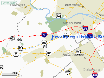
Location & QuickFacts
| FAA Information Effective: | 2008-09-25 |
| Airport Identifier: | 02PN |
| Airport Status: | Operational |
| Longitude/Latitude: | 075-27-18.6950W/40-04-10.3860N
-75.455193/40.069552 (Estimated) |
| Elevation: | 390 ft / 118.87 m (Estimated) |
| Land: | 0 acres |
| From nearest city: | 2 nautical miles N of Berwyn, PA |
| Location: | Chester County, PA |
| Magnetic Variation: | 11W (1985) |
Owner & Manager
| Ownership: | Privately owned |
| Owner: | Philadelphia Electric Co. |
| Address: | 1050 Swedesford Rd.
Berwyn, PA 19312 |
| Phone number: | 215-648-7702 |
| Manager: | Ken Kuhn |
| Address: | 1050 Swedesford Rd
Berwyn, PA 19312 |
| Phone number: | 215-648-7702 |
Airport Operations and Facilities
| Airport Use: | Private |
| Wind indicator: | Yes |
| Segmented Circle: | No |
| Control Tower: | No |
| Lighting Schedule: | RDO-CTL
RDO-CTL 122.9 |
| Landing fee charge: | No |
| Sectional chart: | New York |
| Region: | AEA - Eastern |
| Boundary ARTCC: | ZNY - New York |
| Tie-in FSS: | IPT - Williamsport |
| FSS on Airport: | No |
| FSS Toll Free: | 1-800-WX-BRIEF |
Runway Information
Helipad H1
| Dimension: | 40 x 40 ft / 12.2 x 12.2 m |
| Surface: | ASPH, |
| |
Runway H1 |
Runway |
| Traffic Pattern: | Left | Left |
| Markings: | Nonstandard, Good Condition | , |
|
Radio Navigation Aids
| ID |
Type |
Name |
Ch |
Freq |
Var |
Dist |
| ING | NDB | Ambler | | 275.00 | 11W | 8.5 nm |
| NXX | NDB | Willow Grove | | 388.00 | 12W | 16.0 nm |
| DYL | NDB | Doylestown | | 237.00 | 10W | 22.1 nm |
| UKT | NDB | Quakertown | | 208.00 | 12W | 22.5 nm |
| RNB | NDB | Rainbow | | 363.00 | 11W | 41.8 nm |
| APG | NDB | Aberdeen | | 349.00 | 11W | 44.0 nm |
| LQX | NDB | Carbon | | 339.00 | 12W | 46.7 nm |
| NXX | TACAN | Willow Grove | 061X | | 10W | 16.1 nm |
| PNE | VOR | North Philadelphia | | 112.00 | 10W | 20.5 nm |
| CKZ | VOR/DME | Pennridge | 025Y | 108.85 | 12W | 20.8 nm |
| ARD | VOR/DME | Yardley | 019X | 108.20 | 10W | 27.5 nm |
| ETX | VOR/DME | East Texas | 039X | 110.20 | 09W | 32.5 nm |
| SBJ | VOR/DME | Solberg | 076X | 112.90 | 10W | 45.0 nm |
| PPM | VOR/DME | Phillips | 021X | 108.40 | 09W | 49.1 nm |
| PTW | VORTAC | Pottstown | 112X | 116.50 | 09W | 10.4 nm |
| MXE | VORTAC | Modena | 079X | 113.20 | 09W | 13.5 nm |
| DQO | VORTAC | Dupont | 087X | 114.00 | 10W | 24.5 nm |
| OOD | VORTAC | Woodstown | 075X | 112.80 | 10W | 27.0 nm |
| LRP | VORTAC | Lancaster | 120X | 117.30 | 09W | 38.6 nm |
| VCN | VORTAC | Cedar Lake | 099X | 115.20 | 10W | 39.1 nm |
| FJC | VORTAC | Allentown | 122X | 117.50 | 10W | 39.5 nm |
| GXU | VORTAC | Mc Guire | 043X | 110.60 | 11W | 39.7 nm |
| RBV | VORTAC | Robbinsville | 085X | 113.80 | 10W | 44.8 nm |
| CYN | VORTAC | Coyle | 081X | 113.40 | 10W | 49.5 nm |
| PHL | VOT | Philadelphia Intl | | 109.80 | | 15.4 nm |
Remarks
- VFR SUNRISE TO SUNSET ONLY. INGRESS AND EGRESS ROUTES FROM EAST AND WEST QUADRANTS ONLY.
Images and information placed above are from
http://www.airport-data.com/airport/02PN/
We thank them for the data!
| General Info
|
| Country |
United States
|
| State |
PENNSYLVANIA
|
| FAA ID |
02PN
|
| Latitude |
40-04-10.386N
|
| Longitude |
075-27-18.695W
|
| Elevation |
390 feet
|
| Near City |
BERWYN
|
We don't guarantee the information is fresh and accurate. The data may
be wrong or outdated.
For more up-to-date information please refer to other sources.
|
|


