 |
|
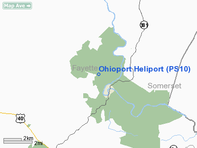
Location & QuickFacts
| FAA Information Effective: | 2008-09-25 |
| Airport Identifier: | PS10 |
| Airport Status: | Operational |
| Longitude/Latitude: | 079-30-27.1390W/39-53-07.2700N
-79.507539/39.885353 (Estimated) |
| Elevation: | 2018 ft / 615.09 m (Estimated) |
| Land: | 2 acres |
| From nearest city: | 1 nautical miles SW of Ohiopyle, PA |
| Location: | Fayette County, PA |
| Magnetic Variation: | 08W (1985) |
Owner & Manager
| Ownership: | Privately owned |
| Owner: | Pa Der, Bureau Of Forestry |
| Address: | P.o. Box 8552
Harrisburg, PA 17105-8552 |
| Phone number: | 717-787-2925 |
| Manager: | Forrest E. Kissinger |
| Address: | P.o. Box 8552
Harrisburg, PA 17105-8552 |
| Phone number: | 412-238-9533 |
Airport Operations and Facilities
| Airport Use: | Private |
| Wind indicator: | Yes |
| Segmented Circle: | No |
| Control Tower: | No |
| Sectional chart: | Cincinnati |
| Region: | AEA - Eastern |
| Boundary ARTCC: | ZOB - Cleveland |
| Tie-in FSS: | AOO - Altoona |
| FSS on Airport: | No |
| FSS Toll Free: | 1-800-WX-BRIEF |
Runway Information
Helipad H1
| Dimension: | 45 x 45 ft / 13.7 x 13.7 m |
| Surface: | ASPH, |
| |
Runway H1 |
Runway |
| Traffic Pattern: | Left | Left |
|
Radio Navigation Aids
| ID |
Type |
Name |
Ch |
Freq |
Var |
Dist |
| VV | NDB | Camor | | 299.00 | 08W | 10.9 nm |
| SYS | NDB | Stoystown | | 209.00 | 08W | 29.8 nm |
| MKP | NDB | Mc Keesport | | 287.00 | 07W | 30.9 nm |
| BHU | NDB | Benje | | 382.00 | 07W | 31.4 nm |
| PNU | NDB | Washington County | | 255.00 | 08W | 33.9 nm |
| CBE | NDB | Cumberland | | 317.00 | 07W | 37.9 nm |
| INP | NDB | Indiana | | 242.00 | 08W | 49.2 nm |
| GRV | VOR/DME | Grantsville | 070X | 112.30 | 06W | 25.9 nm |
| AGC | VOR/DME | Allegheny | 037X | 110.00 | 09W | 34.1 nm |
| ESL | VOR/DME | Kessel | 045X | 110.80 | 06W | 46.4 nm |
| IHD | VORTAC | Indian Head | 019X | 108.20 | 06W | 8.7 nm |
| MGW | VORTAC | Morgantown | 053X | 111.60 | 05W | 25.6 nm |
| JST | VORTAC | Johnstown | 077X | 113.00 | 06W | 40.4 nm |
| MMJ | VORTAC | Montour | 057X | 112.00 | 08W | 48.0 nm |
Images and information placed above are from
http://www.airport-data.com/airport/PS10/
We thank them for the data!
| General Info
|
| Country |
United States
|
| State |
PENNSYLVANIA
|
| FAA ID |
PS10
|
| Latitude |
39-53-07.270N
|
| Longitude |
079-30-27.139W
|
| Elevation |
2018 feet
|
| Near City |
OHIOPYLE
|
We don't guarantee the information is fresh and accurate. The data may
be wrong or outdated.
For more up-to-date information please refer to other sources.
|
|


