|
|
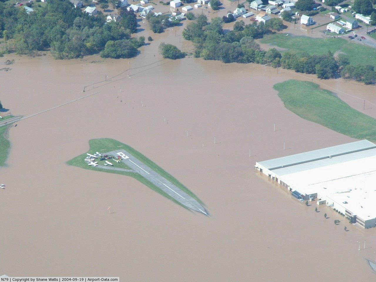
Northumberland County Airport |
 |
(Click on the photo to enlarge) |
Location & QuickFacts
| FAA Information Effective: | 2008-09-25 |
| Airport Identifier: | N79 |
| Airport Status: | Operational |
| Longitude/Latitude: | 076-33-08.8420W/40-50-12.9230N
-76.552456/40.836923 (Estimated) |
| Elevation: | 881 ft / 268.53 m (Surveyed) |
| Land: | 125 acres |
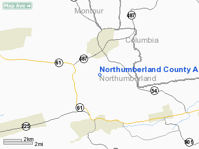
| From nearest city: | 3 nautical miles N of Shamokin, PA |
| Location: | Northumberland County, PA |
| Magnetic Variation: | 11W (1995) |
Owner & Manager
| Ownership: | Publicly owned |
| Owner: | Northumberland Co Apt Auth |
| Address: | 1387 Airport Road
Paxinos, PA 17860 |
| Phone number: | 570-672-2299
AFTER HOURS 570-898-8588 |
| Manager: | Ron Smith |
| Address: | 1387 Airport Road
Paxinos, PA 17860 |
| Phone number: | 570-373-5511 |
Airport Operations and Facilities
| Airport Use: | Open to public |
| Wind indicator: | Yes |
| Segmented Circle: | Yes |
| Control Tower: | No |
| Lighting Schedule: | DUSK-DAWN
ACTVT MIRL RY 08/26 AND PAPI RYS 08 & 26 - 121.8. |
| Beacon Color: | Clear-Green (lighted land airport) |
| Landing fee charge: | No |
| Sectional chart: | New York |
| Region: | AEA - Eastern |
| Boundary ARTCC: | ZNY - New York |
| Tie-in FSS: | IPT - Williamsport |
| FSS on Airport: | No |
| FSS Toll Free: | 1-800-WX-BRIEF
FOR PICKUP CLEARANCE TOLL FREE CALL 800-932-0712. |
| NOTAMs Facility: | IPT (NOTAM-d service avaliable) |
| Federal Agreements: | NGY |
Airport Communications
| CTAF: | 122.800 |
| Unicom: | 122.800 |
Airport Services
| Fuel available: | 100LLA |
| Airframe Repair: | MAJOR |
| Power Plant Repair: | MAJOR |
| Bottled Oxygen: | NONE |
| Bulk Oxygen: | NONE |
Runway Information
Runway 08/26
| Dimension: | 3297 x 75 ft / 1004.9 x 22.9 m |
| Surface: | ASPH, Good Condition |
| Weight Limit: | Single wheel: 12500 lbs. |
| Edge Lights: | Medium |
| |
Runway 08 |
Runway 26 |
| Longitude: | 076-33-29.2870W | 076-32-48.3940W |
| Latitude: | 40-50-08.0030N | 40-50-17.8430N |
| Elevation: | 853.00 ft | 881.00 ft |
| Alignment: | 72 | 127 |
| Traffic Pattern: | Left | Left |
| Markings: | Non-precision instrument, Good Condition | Non-precision instrument, Good Condition |
| Crossing Height: | 40.00 ft | 40.00 ft |
| VASI: | 2-light PAPI on left side | 2-light PAPI on left side |
| Visual Glide Angle: | 3.00° | 3.00° |
| Runway End Identifier: | Yes | Yes |
| Obstruction: | 14 ft trees, 391.0 ft from runway, 258 ft left of centerline, 13:1 slope to clear | 46 ft trees, 1808.0 ft from runway, 239 ft right of centerline, 35:1 slope to clear |
|
Radio Navigation Aids
| ID |
Type |
Name |
Ch |
Freq |
Var |
Dist |
| BZJ | NDB | Bellgrove | | 328.00 | 10W | 24.1 nm |
| HXM | NDB | Humbolt | | 366.00 | 10W | 26.8 nm |
| PIX | NDB | Picture Rocks | | 344.00 | 09W | 27.4 nm |
| LQX | NDB | Carbon | | 339.00 | 12W | 36.1 nm |
| CYE | NDB | Crystal Lake | | 410.00 | 11W | 39.6 nm |
| HZL | VOR | Hazleton | | 109.40 | 09W | 21.1 nm |
| FQM | VOR/DME | Williamsport | 091X | 114.40 | 09W | 31.8 nm |
| ETX | VOR/DME | East Texas | 039X | 110.20 | 09W | 42.5 nm |
| MIP | VORTAC | Milton | 029X | 109.20 | 09W | 12.3 nm |
| SEG | VORTAC | Selinsgrove | 041X | 110.40 | 08W | 15.3 nm |
| RAV | VORTAC | Ravine | 093X | 114.60 | 11W | 17.2 nm |
| HAR | VORTAC | Harrisburg | 072X | 112.50 | 10W | 39.9 nm |
| LRP | VORTAC | Lancaster | 120X | 117.30 | 09W | 44.7 nm |
| LVZ | VORTAC | Wilkes-barre | 053X | 111.60 | 10W | 47.1 nm |
| MDT | VOT | Harrisburg International | | 110.00 | | 39.6 nm |
Remarks
Images and information placed above are from
http://www.airport-data.com/airport/N79/
We thank them for the data!
| General Info
|
| Country |
United States
|
| State |
PENNSYLVANIA
|
| FAA ID |
N79
|
| Latitude |
40-50-12.923N
|
| Longitude |
076-33-08.842W
|
| Elevation |
881 feet
|
| Near City |
SHAMOKIN
|
We don't guarantee the information is fresh and accurate. The data may
be wrong or outdated.
For more up-to-date information please refer to other sources.
|
|