|
|
Northeast Philadelphia Airport |
| Northeast Philadelphia Airport |
 |
| IATA: PNE – ICAO: KPNE – FAA LID: PNE |
| Summary |
| Airport type |
Public |
| Owner |
City of Philadelphia |
| Serves |
Philadelphia, Pennsylvania |
| Elevation AMSL |
121 ft / 37 m |
| Coordinates |
40°04′55″N 075°00′38″W / 40.08194°N 75.01056°W / 40.08194; -75.01056 |
| Website |
www.phl.org/pne/... |
| Runways |
| Direction |
Length |
Surface |
| ft |
m |
| 6/24 |
7,000 |
2,134 |
Asphalt |
| 15/33 |
5,000 |
1,524 |
Asphalt |
| Statistics (2006) |
| Aircraft operations |
105,609 |
| Based aircraft |
203 |
| Sources: airport website and FAA |
Northeast Philadelphia Airport (IATA: PNE, ICAO: KPNE, FAA LID: PNE) is a public airport located just north of the intersection of Grant Avenue and Ashton Road in the Ashton-Woodenbridge neighborhood of Northeast Philadelphia. It is part of the Philadelphia Airport System along with Philadelphia International Airport, and is the general aviation reliever airport for Philadelphia International Airport. Northeast Philadelphia Airport is the sixth busiest airport in Pennsylvania. Services at the airport provided by two fixed base operators include fuel, major aircraft repair, hangar rental, aircraft rental and charter, flight instruction, and aircraft sales. Location
This airport covers 1,240 acres (5 km²), and is located on a site approximately bounded by Grant Avenue to the south, Academy Road to the east, Comly Road to the north, and the Roosevelt Boulevard (U.S. 1) to the west. The airport does not extend all the way to these boundaries, however. Development within these boundaries also includes the Internal Revenue Service Philadelphia Service Center, a Pepsi-Cola bottling plant, an industrial park with aviation-related businesses, and the headquarters of the 8 District of the Philadelphia Police Department. A TJ Maxx distribution center and an ice skating rink opened in 2001 on land leased from the airport.
When this airport was opened, the surrounding area was largely open farmland. Since that time, much growth has taken place in Northeast Philadelphia, and residential neighborhoods and businesses have developed close to the airport. Because of this development, pilots operating in proximity of the airport must observe noise abatement procedures.
History
The Northeast Philadelphia Airport had its origin in the 1930s, maybe in the late 20s, as the Northeast Airport, a grass field with no paved runways. It was one of three small airports in the area for private aviation. Just across Roosevelt Boulevard to the west, adjacent to Red Lion Road, was the Boulevard Airport, the most important of the three. Further west was the Somerton Airport, no longer in existence, close enough that pilots had to be careful not to infringe on adjacent traffic patterns. The site of the Boulevard Airport is now a shopping mall and housing. The Northeast Airport was the site for the development of the large airport that exists today. The United States Army Air Corps began construction of a 545 acre (2.2 km²) airbase in Northeast Philadelphia during World War II, but the project was never completed, and the property was turned over to the city in 1944. After the city finished the work, Philadelphia Northeast Airport opened in June 1945. In 1948, the name of the airport was changed to North Philadelphia Airport. The airport's infrastructure was expanded in 1960 when Runway 6/24 was extended to its present length. The name of the airport was changed once again in 1980, to the present Northeast Philadelphia Airport.
Facilities and aircraft
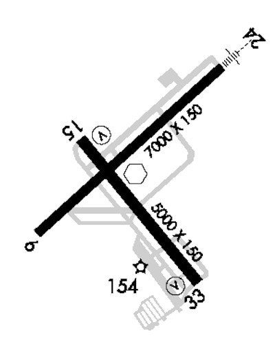
Northeast Philadelphia Airport covers an area of 1,150 acres (465 ha) at an elevation of 121 feet (37 m) above mean sea level. It has two asphalt paved runways: 6/24 measuring 7,000 by 150 feet (2,134 x 46 m) and 15/33 measuring 5,000 by 150 feet (1,524 x 46 m).
For the 12-month period ending December 31, 2006, the airport had 105,609 aircraft operations, an average of 289 per day: 99% general aviation and 1% military. At that time there were 203 aircraft based at this airport: 62% single-engine, 27% multi-engine, 6% jet and 5% helicopter.
The above content comes from Wikipedia and is published under free licenses – click here to read more.

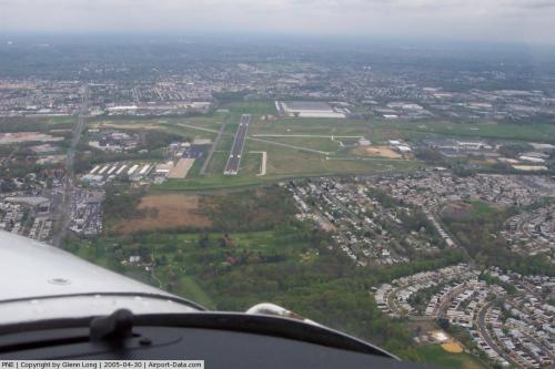 |
(Click on the photo to enlarge) |
Location & QuickFacts
| FAA Information Effective: | 2008-09-25 |
| Airport Identifier: | PNE |
| Airport Status: | Operational |
| Longitude/Latitude: | 075-00-38.1120W/40-04-54.9990N
-75.010587/40.081944 (Estimated) |
| Elevation: | 121 ft / 36.88 m (Surveyed) |
| Land: | 1150 acres |
| From nearest city: | 10 nautical miles NE of Philadelphia, PA |
| Location: | Philadelphia County, PA |
| Magnetic Variation: | 12W (2005) |
Owner & Manager
| Ownership: | Publicly owned |
| Owner: | City Of Philadelphia |
| Address: | Philadelphia Int Arpt
Philadelphia, PA 19153 |
| Phone number: | 215-937-6800 |
| Manager: | John Brewer |
| Address: | 9800 Ashton Road
Philadelphia, PA 19114 |
| Phone number: | 215-937-7968 |
Airport Operations and Facilities
| Airport Use: | Open to public |
| Wind indicator: | Yes |
| Segmented Circle: | No |
| Control Tower: | Yes |
| Lighting Schedule: | DUSK-DAWN
WHEN ATCT CLSD HIRL RY 06/24 PRESET MED INTST; ACTVT MALSR RY 24 - CTAF. |
| Beacon Color: | Clear-Green (lighted land airport) |
| Landing fee charge: | Yes |
| Sectional chart: | New York |
| Region: | AEA - Eastern |
| Boundary ARTCC: | ZDC - Washington |
| Responsible ARTCC: | ZNY - New York |
| Tie-in FSS: | IPT - Williamsport |
| FSS on Airport: | No |
| FSS Toll Free: | 1-800-WX-BRIEF |
| NOTAMs Facility: | PNE (NOTAM-d service avaliable) |
| Federal Agreements: | NGY3 |
Airport Communications
| CTAF: | 126.900 |
| Unicom: | 122.950 |
Airport Services
| Fuel available: | 100LLA |
| Airframe Repair: | MAJOR |
| Power Plant Repair: | MAJOR |
| Bottled Oxygen: | HIGH/LOW |
| Bulk Oxygen: | HIGH |
Runway Information
Runway 06/24
| Dimension: | 7000 x 150 ft / 2133.6 x 45.7 m |
| Surface: | ASPH, Good Condition |
| Surface Treatment: | Saw-cut or plastic Grooved |
| Weight Limit: | Single wheel: 60000 lbs.
Dual wheel: 90000 lbs. |
| Edge Lights: | High |
| |
Runway 06 |
Runway 24 |
| Longitude: | 075-01-12.9370W | 075-00-05.5840W |
| Latitude: | 40-04-39.0230N | 40-05-24.9370N |
| Elevation: | 112.00 ft | 114.00 ft |
| Alignment: | 48 | 127 |
| ILS Type: | | ILS
|
| Traffic Pattern: | Left | Left |
| Markings: | Precision instrument, Good Condition | Precision instrument, Good Condition |
| Crossing Height: | 57.00 ft | 52.00 ft |
| VASI: | 4-light PAPI on left side | 4-light PAPI on right side |
| Visual Glide Angle: | 3.00° | 3.00° |
| Approach lights: | | MALSR |
| Runway End Identifier: | Yes | |
| Obstruction: | 12 ft trees, 425.0 ft from runway, 298 ft right of centerline, 19:1 slope to clear
RY 06 HAS +35 FT TREES, 188 FT FM RY END, 324 FT L. | , 50:1 slope to clear |
|
Runway 15/33
| Dimension: | 5000 x 150 ft / 1524.0 x 45.7 m |
| Surface: | ASPH, Good Condition |
| Surface Treatment: | Saw-cut or plastic Grooved |
| Weight Limit: | Single wheel: 40000 lbs.
Dual wheel: 55000 lbs. |
| Edge Lights: | Medium |
| |
Runway 15 |
Runway 33 |
| Longitude: | 075-00-56.8050W | 075-00-16.0600W |
| Latitude: | 40-05-04.2830N | 40-04-26.0540N |
| Elevation: | 120.00 ft | 109.00 ft |
| Alignment: | 127 | 127 |
| Traffic Pattern: | Left | Left |
| Markings: | Non-precision instrument, Good Condition | Non-precision instrument, Good Condition |
| Crossing Height: | 41.00 ft | 39.00 ft |
| VASI: | 4-box on left side | 4-box on left side |
| Visual Glide Angle: | 3.00° | 3.00° |
| Runway End Identifier: | Yes | Yes |
| Obstruction: | 21 ft gnd, 1027.0 ft from runway, 215 ft left of centerline, 39:1 slope to clear | 22 ft trees, 765.0 ft from runway, 263 ft left of centerline, 25:1 slope to clear |
|
Radio Navigation Aids
| ID |
Type |
Name |
Ch |
Freq |
Var |
Dist |
| NXX | NDB | Willow Grove | | 388.00 | 12W | 8.9 nm |
| ING | NDB | Ambler | | 275.00 | 11W | 12.9 nm |
| DYL | NDB | Doylestown | | 237.00 | 10W | 16.1 nm |
| UKT | NDB | Quakertown | | 208.00 | 12W | 24.5 nm |
| NEL | NDB | Lakehurst | | 396.00 | 13W | 31.1 nm |
| RNB | NDB | Rainbow | | 363.00 | 11W | 40.3 nm |
| CAT | NDB | Chatham | | 254.00 | 11W | 47.7 nm |
| NXX | TACAN | Willow Grove | 061X | | 10W | 9.2 nm |
| NEL | TACAN | Lakehurst | 055X | | 11W | 30.4 nm |
| NEL | UHF/NDB | Lakehurst | | 274.80 | 13W | 31.1 nm |
| ARD | VOR/DME | Yardley | 019X | 108.20 | 10W | 11.3 nm |
| CKZ | VOR/DME | Pennridge | 025Y | 108.85 | 12W | 22.5 nm |
| SBJ | VOR/DME | Solberg | 076X | 112.90 | 10W | 32.5 nm |
| COL | VOR/DME | Colts Neck | 101X | 115.40 | 11W | 41.4 nm |
| ETX | VOR/DME | East Texas | 039X | 110.20 | 09W | 43.0 nm |
| BWZ | VOR/DME | Broadway | 089X | 114.20 | 11W | 43.9 nm |
| GXU | VORTAC | Mc Guire | 043X | 110.60 | 11W | 19.6 nm |
| RBV | VORTAC | Robbinsville | 085X | 113.80 | 10W | 24.8 nm |
| PTW | VORTAC | Pottstown | 112X | 116.50 | 09W | 26.6 nm |
| OOD | VORTAC | Woodstown | 075X | 112.80 | 10W | 30.0 nm |
| CYN | VORTAC | Coyle | 081X | 113.40 | 10W | 31.1 nm |
| MXE | VORTAC | Modena | 079X | 113.20 | 09W | 32.0 nm |
| VCN | VORTAC | Cedar Lake | 099X | 115.20 | 10W | 32.8 nm |
| DQO | VORTAC | Dupont | 087X | 114.00 | 10W | 36.7 nm |
| ACY | VORTAC | Atlantic City | 023X | 108.60 | 10W | 42.6 nm |
| FJC | VORTAC | Allentown | 122X | 117.50 | 10W | 43.8 nm |
| PHL | VOT | Philadelphia Intl | | 109.80 | | 16.7 nm |
Remarks
- TURBOJET ACFT ARE CONFINED TO FULL LENGTH RWY 6/24 UNLESS STRONG WINDS DICTATE OTHERWISE.
- RY 15 IS NOISE SENSITIVE; UNLESS WINDS ARE 110-190 AT 8 KNOTS OR MORE THIS RY WILL NOT BE ASSIGNED. RY 15 ARRIVALS ARE REQUESTED TO FLY AT OR ABOVE GLIDE PATH.
- ARPT CLSD TO ACR WITH 9 OR MORE PASSENGERS.
- DEER & BIRDS ON & INVOF ARPT.
-
- TPA ACFT LESS THAN 12500 LBS 1120 MSL; ACFT 12500 LBS OR MORE & ALL TURBOJET & TURBINE PWRD ACFT 1620 MSL; ROTARY WING ACFT 920 MSL.
- TWYS C FROM C3 TO THE AER 33 AND TWY C3 RSTD TO DESIGN GROUP 1 & 2 ACFT ONLY.
- BE ALERT FOR ARPT VEHICLES WHEN TWR CLSD.
Images and information placed above are from
http://www.airport-data.com/airport/PNE/
We thank them for the data!
| General Info
|
| Country |
United States
|
| State |
PENNSYLVANIA
|
| FAA ID |
PNE
|
| Latitude |
40-04-54.999N
|
| Longitude |
075-00-38.112W
|
| Elevation |
121 feet
|
| Near City |
PHILADELPHIA
|
We don't guarantee the information is fresh and accurate. The data may
be wrong or outdated.
For more up-to-date information please refer to other sources.
|
|