|
|
| New Castle Municipal Airport |
| IATA: none – ICAO: KUCP – FAA LID: UCP |
| Summary |
| Airport type |
Public |
| Owner |
Lawrence County Airport Authority |
| Serves |
New Castle, Pennsylvania |
| Location |
Union Township |
| Elevation AMSL |
1070 ft / 326 m |
| Coordinates |
41°01′31″N 080°24′48″W / 41.02528°N 80.41333°W / 41.02528; -80.41333 |
| Runways |
| Direction |
Length |
Surface |
| ft |
m |
| 5/23 |
3,995 |
1,218 |
Asphalt |
| 13/31 |
2,475 |
837 |
Asphalt |
| Statistics (2009) |
| Aircraft operations |
35,357 |
| Based aircraft |
58 |
| Source: Federal Aviation Administration |
This article is about the airport in Pennsylvania.For other similarly named airports, see New Castle Airport (disambiguation).
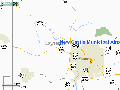
New Castle Municipal Airport (ICAO: KUCP, FAA LID: UCP) is a small municipal airport located in Union Township, Lawrence County, Pennsylvania serving Lawrence County, Pennsylvania. Union Township is an outskirt of New Castle, Pennsylvania hence the name. The airport is located four nautical miles (7 km) northwest of the central business district of New Castle. The airport is a public-owned airport and is controlled by the Lawrence County Airport Authority.
Although most U.S. airports use the same three-letter location identifier for the FAA and IATA, this airport is assigned UCP by the FAA but has no designation from the IATA.
Facilities and aircraft
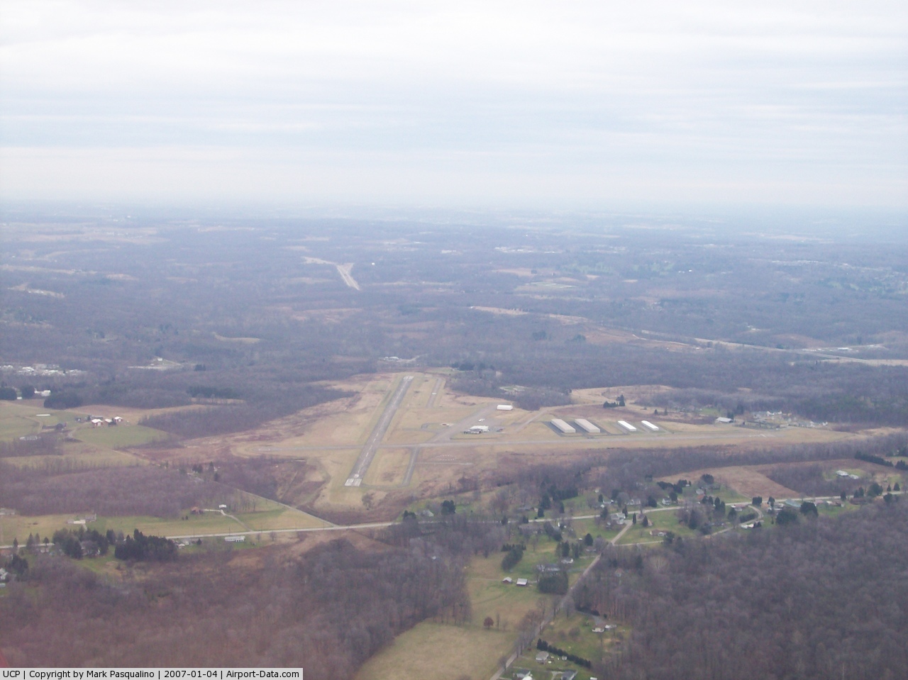
New Castle Municipal Airport covers an area of 320 acres (129 ha) at an elevation of 1,070 feet (326 m) above mean sea level. It has two asphalt paved runways: 5/23 is 3,995 by 75 feet (1,218 x 23 m) and 13/31 is 2,745 by 100 feet (837 x 30 m).
The airport's fixed base operator (FBO) is Haski Aviation.
For the 12-month period ending February 28, 2009, the airport had 35,357 aircraft operations, an average of 96 per day: 97% general aviation, 3% air taxi and <1% military. At that time there were 58 aircraft based at this airport: 96% single-engine, 2% multi-engine and 2% helicopter.
The above content comes from Wikipedia and is published under free licenses – click here to read more.
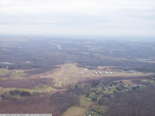 |
(Click on the photo to enlarge) |
Location & QuickFacts
| FAA Information Effective: | 2008-09-25 |
| Airport Identifier: | UCP |
| Airport Status: | Operational |
| Longitude/Latitude: | 080-24-48.4000W/41-01-31.4000N
-80.413444/41.025389 (Estimated) |
| Elevation: | 1070 ft / 326.14 m (Surveyed) |
| Land: | 320 acres |
| From nearest city: | 4 nautical miles NW of New Castle, PA |
| Location: | Lawrence County, PA |
| Magnetic Variation: | 09W (2005) |
Owner & Manager
| Ownership: | Publicly owned |
| Owner: | Lawrence Co. Airport Authority |
| Address: | 230 N Jefferson
New Castle, PA 16101 |
| Phone number: | 724-656-3515 |
| Manager: | Marty Haski |
| Address: | 406 Frank Farone Drive
New Castle, PA 16101 |
| Phone number: | 724-652-5546 |
Airport Operations and Facilities
| Airport Use: | Open to public |
| Wind indicator: | Yes |
| Segmented Circle: | Yes |
| Control Tower: | No |
| Lighting Schedule: | DUSK-DAWN
ACTVT MIRL RY 05/23; PAPI RYS 05/23 & RY 13/31; REILS RYS 05 & 23 - CTAF. |
| Beacon Color: | Clear-Green (lighted land airport) |
| Landing fee charge: | No |
| Sectional chart: | Detroit |
| Region: | AEA - Eastern |
| Boundary ARTCC: | ZOB - Cleveland |
| Tie-in FSS: | AOO - Altoona |
| FSS on Airport: | No |
| FSS Toll Free: | 1-800-WX-BRIEF |
| NOTAMs Facility: | AOO (NOTAM-d service avaliable) |
| Federal Agreements: | NGY |
Airport Communications
| CTAF: | 123.000 |
| Unicom: | 123.000 |
Airport Services
| Fuel available: | 100LLA |
| Airframe Repair: | MAJOR |
| Power Plant Repair: | MAJOR |
| Bottled Oxygen: | NONE |
| Bulk Oxygen: | NONE |
Runway Information
Runway 05/23
| Dimension: | 3995 x 75 ft / 1217.7 x 22.9 m |
| Surface: | ASPH, Fair Condition |
| Weight Limit: | Single wheel: 12500 lbs. |
| Edge Lights: | Medium |
| |
Runway 05 |
Runway 23 |
| Longitude: | 080-25-05.2632W | 080-24-31.9133W |
| Latitude: | 41-01-20.8385N | 41-01-51.1738N |
| Elevation: | 1022.00 ft | 1007.00 ft |
| Alignment: | 39 | 127 |
| Traffic Pattern: | Left | Left |
| Markings: | Non-precision instrument, Fair Condition | Non-precision instrument, Fair Condition |
| Crossing Height: | 53.00 ft | 59.00 ft |
| VASI: | 4-light PAPI on left side | 4-light PAPI on left side |
| Visual Glide Angle: | 3.00° | 3.00° |
| Runway End Identifier: | Yes | Yes |
| Obstruction: | 53 ft tree, 902.0 ft from runway, 300 ft right of centerline, 13:1 slope to clear
RY 5 HAS +6 FT BRUSH, 133 FT FM RY END, 82 FT RT +6 FT BRUSH, 179 FT FM RY END, 78 FT RIGHT. | 31 ft trees, 569.0 ft from runway, 297 ft right of centerline, 11:1 slope to clear
END RAISED BY 9' TAPERING TO HEIGHT OF EXISTING RY 1600' BEHIND THR. |
|
Runway 13/31
| Dimension: | 2745 x 100 ft / 836.7 x 30.5 m |
| Surface: | ASPH, Fair Condition |
| Weight Limit: | Single wheel: 12500 lbs. |
| |
Runway 13 |
Runway 31 |
| Longitude: | 080-25-03.7182W | 080-24-32.3386W |
| Latitude: | 41-01-31.2437N | 41-01-18.1921N |
| Elevation: | 1016.00 ft | 1070.00 ft |
| Alignment: | 118 | 127 |
| Traffic Pattern: | Left | Left |
| Markings: | Basic, Fair Condition | Basic, Fair Condition |
| Crossing Height: | 55.00 ft | 57.00 ft |
| VASI: | 2-light PAPI on left side | 4-light PAPI on left side |
| Visual Glide Angle: | 3.00° | 3.00° |
| Obstruction: | , 50:1 slope to clear
RY 13 HAS +3 FT BRUSH, 120 FT FM RY END, 1 FT LEFT. | 30 ft trees, 420.0 ft from runway, 73 ft right of centerline, 7:1 slope to clear
RY 31 APCH SLOPE 17:1 TO DSPLCD THLD. |
|
Radio Navigation Aids
| ID |
Type |
Name |
Ch |
Freq |
Var |
Dist |
| UCP | NDB | Castle | | 272.00 | 09W | 0.2 nm |
| HBD | NDB | Hubbard | | 408.00 | 08W | 9.3 nm |
| TSO | NDB | Tolson | | 395.00 | 07W | 41.1 nm |
| AK | NDB | Akron | | 362.00 | 07W | 44.2 nm |
| MKP | NDB | Mc Keesport | | 287.00 | 07W | 49.5 nm |
| FKL | VOR | Franklin | | 109.60 | 06W | 35.4 nm |
| ACO | VOR/DME | Akron | 091X | 114.40 | 04W | 36.1 nm |
| CIP | VOR/DME | Clarion | 076X | 112.90 | 06W | 43.9 nm |
| CXR | VOR/DME | Chardon | 074X | 112.70 | 05W | 44.9 nm |
| HLG | VOR/DME | Wheeling | 059X | 112.20 | 07W | 46.6 nm |
| JFN | VOR/DME | Jefferson | 099X | 115.20 | 05W | 46.7 nm |
| AGC | VOR/DME | Allegheny | 037X | 110.00 | 09W | 48.0 nm |
| BSV | VOR/DME | Briggs | 071X | 112.40 | 04W | 49.4 nm |
| EWC | VORTAC | Ellwood City | 105X | 115.80 | 08W | 15.1 nm |
| YNG | VORTAC | Youngstown | 027X | 109.00 | 05W | 21.8 nm |
| MMJ | VORTAC | Montour | 057X | 112.00 | 08W | 33.8 nm |
| CAK | VOT | Akron/canton Regional | | 110.60 | | 47.1 nm |
Remarks
Images and information placed above are from
http://www.airport-data.com/airport/UCP/
We thank them for the data!
| General Info
|
| Country |
United States
|
| State |
PENNSYLVANIA
|
| FAA ID |
UCP
|
| Latitude |
41-01-31.216N
|
| Longitude |
080-24-48.139W
|
| Elevation |
1072 feet
|
| Near City |
NEW CASTLE
|
We don't guarantee the information is fresh and accurate. The data may
be wrong or outdated.
For more up-to-date information please refer to other sources.
|
|