 |
|
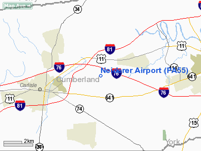
Location & QuickFacts
| FAA Information Effective: | 2008-09-25 |
| Airport Identifier: | PA55 |
| Airport Status: | Operational |
| Longitude/Latitude: | 077-06-58.9260W/40-13-00.3190N
-77.116368/40.216755 (Estimated) |
| Elevation: | 440 ft / 134.11 m (Estimated) |
| Land: | 10 acres |
| From nearest city: | 3 nautical miles E of Carlisle, PA |
| Location: | Cumberland County, PA |
| Magnetic Variation: | 10W (1985) |
Owner & Manager
| Ownership: | Privately owned |
| Owner: | Richard A Neiderer |
| Address: | 281 Old Stone House Rd
Carlisle, PA 17013 |
| Phone number: | 717-243-4402 |
| Address: |
|
Airport Operations and Facilities
| Airport Use: | Private |
| Wind indicator: | No |
| Segmented Circle: | No |
| Control Tower: | No |
| Landing fee charge: | No |
| Sectional chart: | Detroit |
| Region: | AEA - Eastern |
| Boundary ARTCC: | ZNY - New York |
| Tie-in FSS: | IPT - Williamsport |
| FSS on Airport: | No |
| FSS Toll Free: | 1-800-WX-BRIEF |
Airport Services
| Airframe Repair: | NONE |
| Power Plant Repair: | NONE |
Runway Information
Runway E/W
| Dimension: | 1400 x 200 ft / 426.7 x 61.0 m |
| Surface: | TURF, |
| |
Runway E |
Runway W |
| Traffic Pattern: | Left | Left |
|
Radio Navigation Aids
| ID |
Type |
Name |
Ch |
Freq |
Var |
Dist |
| EUD | NDB | York | | 254.00 | 11W | 20.9 nm |
| BZJ | NDB | Bellgrove | | 328.00 | 10W | 29.0 nm |
| RV | NDB | Stroh | | 407.00 | 10W | 36.5 nm |
| HGR | VOR | Hagerstown | | 109.80 | 07W | 46.2 nm |
| FDK | VOR | Frederick | | 109.00 | 08W | 49.8 nm |
| HAR | VORTAC | Harrisburg | 072X | 112.50 | 10W | 5.6 nm |
| RAV | VORTAC | Ravine | 093X | 114.60 | 11W | 31.1 nm |
| SEG | VORTAC | Selinsgrove | 041X | 110.40 | 08W | 36.1 nm |
| LRP | VORTAC | Lancaster | 120X | 117.30 | 09W | 38.3 nm |
| THS | VORTAC | St Thomas | 097X | 115.00 | 07W | 42.0 nm |
| EMI | VORTAC | Westminster | 126X | 117.90 | 08W | 43.8 nm |
| MDT | VOT | Harrisburg International | | 110.00 | | 16.2 nm |
Remarks
Images and information placed above are from
http://www.airport-data.com/airport/PA55/
We thank them for the data!
| General Info
|
| Country |
United States
|
| State |
PENNSYLVANIA
|
| FAA ID |
PA55
|
| Latitude |
40-13-00.319N
|
| Longitude |
077-06-58.926W
|
| Elevation |
440 feet
|
| Near City |
CARLISLE
|
We don't guarantee the information is fresh and accurate. The data may
be wrong or outdated.
For more up-to-date information please refer to other sources.
|
|


