 |
|
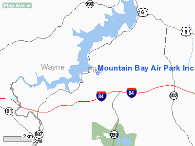
Mountain Bay Air Park Inc Airport |
Location & QuickFacts
| FAA Information Effective: | 2008-09-25 |
| Airport Identifier: | PA49 |
| Airport Status: | Operational |
| Longitude/Latitude: | 075-13-56.6400W/41-22-48.3220N
-75.232400/41.380089 (Estimated) |
| Elevation: | 1500 ft / 457.20 m (Estimated) |
| Land: | 27 acres |
| From nearest city: | 9 nautical miles SW of Hawley, PA |
| Location: | Pike County, PA |
| Magnetic Variation: | 12W (1985) |
Owner & Manager
| Ownership: | Privately owned |
| Owner: | Mountain Bay Airpark Inc |
| Address: | 100 Panderosa Ct
Greentown, PA 18426 |
| Phone number: | 717-857-9366 |
| Manager: | Gunars H. Ramins |
| Address: | 272 Titus Ave
Warrington, PA 18976 |
| Phone number: | 215-343-0708 |
Airport Operations and Facilities
| Airport Use: | Private |
| Wind indicator: | Yes |
| Segmented Circle: | No |
| Control Tower: | No |
| Lighting Schedule: | RDO-CTL
ACTVT MIRL RY 11/29 & ROTG BCN - 122.7. |
| Beacon Color: | Clear-Green (lighted land airport) |
| Landing fee charge: | Yes |
| Sectional chart: | New York |
| Region: | AEA - Eastern |
| Boundary ARTCC: | ZNY - New York |
| Tie-in FSS: | IPT - Williamsport |
| FSS on Airport: | No |
| FSS Toll Free: | 1-800-WX-BRIEF |
Airport Communications
Airport Services
Runway Information
Runway 11/29
| Dimension: | 2230 x 50 ft / 679.7 x 15.2 m |
| Surface: | ASPH, |
| Edge Lights: | Medium |
| |
Runway 11 |
Runway 29 |
| Traffic Pattern: | Left | Left |
| Displaced threshold: | 300.00 ft | 0.00 ft |
| Obstruction: | 10 ft trees, 200.0 ft from runway | |
|
Radio Navigation Aids
| ID |
Type |
Name |
Ch |
Freq |
Var |
Dist |
| MS | NDB | Monga | | 359.00 | 12W | 28.6 nm |
| CYE | NDB | Crystal Lake | | 410.00 | 11W | 28.9 nm |
| LQX | NDB | Carbon | | 339.00 | 12W | 41.7 nm |
| HXM | NDB | Humbolt | | 366.00 | 10W | 41.8 nm |
| SW | NDB | Neely | | 335.00 | 14W | 45.7 nm |
| HZL | VOR | Hazleton | | 109.40 | 09W | 47.2 nm |
| STW | VOR/DME | Stillwater | 033X | 109.60 | 11W | 28.3 nm |
| HUO | VOR/DME | Huguenot | 108X | 116.10 | 11W | 28.9 nm |
| BWZ | VOR/DME | Broadway | 089X | 114.20 | 11W | 39.6 nm |
| HNK | VOR/DME | Hancock | 115X | 116.80 | 11W | 41.2 nm |
| DNY | VOR/DME | De Lancey | 058X | 112.10 | 11W | 49.5 nm |
| LHY | VORTAC | Lake Henry | 045X | 110.80 | 10W | 12.7 nm |
| LVZ | VORTAC | Wilkes-barre | 053X | 111.60 | 10W | 21.6 nm |
| SAX | VORTAC | Sparta | 104X | 115.70 | 11W | 36.6 nm |
| FJC | VORTAC | Allentown | 122X | 117.50 | 10W | 40.5 nm |
Remarks
- TFC PAT ALT 2300 FT MSL.
- CLUB MEMBERSHIP REQUIRED FOR LNDG.
- PRVDD VFR OPNS ONLY.
Images and information placed above are from
http://www.airport-data.com/airport/PA49/
We thank them for the data!
| General Info
|
| Country |
United States
|
| State |
PENNSYLVANIA
|
| FAA ID |
PA49
|
| Latitude |
41-22-48.322N
|
| Longitude |
075-13-56.640W
|
| Elevation |
1500 feet
|
| Near City |
HAWLEY
|
We don't guarantee the information is fresh and accurate. The data may
be wrong or outdated.
For more up-to-date information please refer to other sources.
|
|


