 |
|
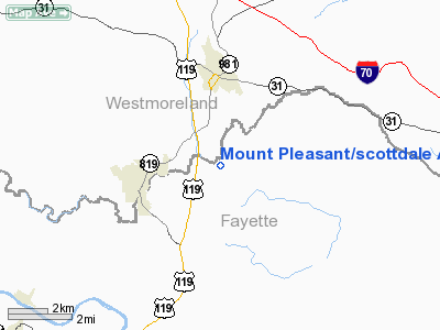
Mount Pleasant/scottdale Airport |
Location & QuickFacts
| FAA Information Effective: | 2008-09-25 |
| Airport Identifier: | P45 |
| Airport Status: | Operational |
| Longitude/Latitude: | 079-32-29.1370W/40-06-30.2600N
-79.541427/40.108406 (Estimated) |
| Elevation: | 1160 ft / 353.57 m (Estimated) |
| Land: | 54 acres |
| From nearest city: | 3 nautical miles S of Mount Pleasant, PA |
| Location: | Fayette County, PA |
| Magnetic Variation: | 08W (1985) |
Owner & Manager
| Ownership: | Privately owned |
| Owner: | James M. Barclay |
| Address: | 276 Airport Rd
Mount Pleasant, PA 15666 |
| Phone number: | 724-887-8888 |
| Manager: | James M. Barclay |
| Address: | 276 Airport Rd
Mount Pleasant, PA 15666 |
| Phone number: | 724-887-8888 |
Airport Operations and Facilities
| Airport Use: | Open to public |
| Wind indicator: | Yes |
| Segmented Circle: | No |
| Control Tower: | No |
| Landing fee charge: | No |
| Sectional chart: | Detroit |
| Region: | AEA - Eastern |
| Boundary ARTCC: | ZOB - Cleveland |
| Tie-in FSS: | AOO - Altoona |
| FSS on Airport: | No |
| FSS Toll Free: | 1-800-WX-BRIEF |
| NOTAMs Facility: | AOO (NOTAM-d service avaliable) |
| Federal Agreements: | N |
Airport Communications
Airport Services
| Fuel available: | 80 |
| Airframe Repair: | MAJOR |
| Power Plant Repair: | MAJOR |
| Bottled Oxygen: | NONE |
| Bulk Oxygen: | NONE |
Runway Information
Runway 06/24
| Dimension: | 2188 x 161 ft / 666.9 x 49.1 m
RWY 06/24 FIRST 375 FT APCH END RY 06 HAS 7 PERCENT GRADIENT. |
| Surface: | TURF, Fair Condition |
| |
Runway 06 |
Runway 24 |
| Traffic Pattern: | Left | Left |
| Markings: | Nonstandard, Fair Condition
RWY 06/24 MKD WITH NSTD YELLOW BOUNDARY MKRS - BARRELS. | Nonstandard, Fair Condition
RWY 06/24 MKD WITH NSTD YELLOW BOUNDARY MKRS - BARRELS. |
| Displaced threshold: | 254.00 ft
RY 06 DSPLCD THLD MKD WITH CONTRASTING RED BOUNDARY MKRS. | 0.00 ft |
| Obstruction: | 48 ft trees, 336.0 ft from runway, 111 ft right of centerline, 7:1 slope to clear
RY 06 APCH RATIO 12:1 TO DSPLCD THLD. | 16 ft pline, 724.0 ft from runway, 105 ft left of centerline, 44:1 slope to clear |
|
Runway 14/32
| Dimension: | 1600 x 220 ft / 487.7 x 67.1 m
RWY 06/24 FIRST 375 FT APCH END RY 06 HAS 7 PERCENT GRADIENT. |
| Surface: | TURF, Fair Condition |
| |
Runway 14 |
Runway 32 |
| Traffic Pattern: | Left | Left |
| Markings: | Nonstandard, Fair Condition
RWY 14/32 MKD WITH YELLOW BOUNDARY MKRS - BARRELS | Nonstandard, Poor Condition
BOUNDARY MARKERS ARE RUSTING. |
| Obstruction: | 11 ft bldg, 4.0 ft from runway, 117 ft right of centerline | 141 ft trees, 2452.0 ft from runway, 301 ft left of centerline, 17:1 slope to clear |
|
Radio Navigation Aids
| ID |
Type |
Name |
Ch |
Freq |
Var |
Dist |
| VV | NDB | Camor | | 299.00 | 08W | 16.5 nm |
| MKP | NDB | Mc Keesport | | 287.00 | 07W | 18.5 nm |
| BHU | NDB | Benje | | 382.00 | 07W | 20.3 nm |
| PNU | NDB | Washington County | | 255.00 | 08W | 28.6 nm |
| SYS | NDB | Stoystown | | 209.00 | 08W | 28.8 nm |
| INP | NDB | Indiana | | 242.00 | 08W | 38.3 nm |
| CBE | NDB | Cumberland | | 317.00 | 07W | 45.9 nm |
| AGC | VOR/DME | Allegheny | 037X | 110.00 | 09W | 25.1 nm |
| GRV | VOR/DME | Grantsville | 070X | 112.30 | 06W | 36.4 nm |
| REC | VOR/DME | Revloc | 043X | 110.60 | 09W | 44.9 nm |
| HLG | VOR/DME | Wheeling | 059X | 112.20 | 07W | 48.0 nm |
| IHD | VORTAC | Indian Head | 019X | 108.20 | 06W | 11.7 nm |
| JST | VORTAC | Johnstown | 077X | 113.00 | 06W | 34.8 nm |
| MGW | VORTAC | Morgantown | 053X | 111.60 | 05W | 36.3 nm |
| MMJ | VORTAC | Montour | 057X | 112.00 | 08W | 37.6 nm |
Remarks
- DURG SPRING THAW & WET PERIODS CALL FOR ARPT AVAILABILITY 724-887-8888.
- EXTSV HELICOPTER ACTVTY AT ADJ HELIPORT.
- ULTRALIGHT ACTIVITY ON & INVOF ARPT.
- BOTH RY SFCS ARE ROLLING.
- VFR OPNS ONLY
Images and information placed above are from
http://www.airport-data.com/airport/P45/
We thank them for the data!
| General Info
|
| Country |
United States
|
| State |
PENNSYLVANIA
|
| FAA ID |
P45
|
| Latitude |
40-06-30.260N
|
| Longitude |
079-32-29.137W
|
| Elevation |
1160 feet
|
| Near City |
MOUNT PLEASANT
|
We don't guarantee the information is fresh and accurate. The data may
be wrong or outdated.
For more up-to-date information please refer to other sources.
|
|


