 |
|
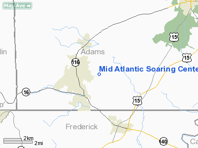
Mid Atlantic Soaring Center Airport |
Location & QuickFacts
| FAA Information Effective: | 2008-09-25 |
| Airport Identifier: | W73 |
| Airport Status: | Operational |
| Longitude/Latitude: | 077-21-04.9540W/39-45-25.3440N
-77.351376/39.757040 (Estimated) |
| Elevation: | 573 ft / 174.65 m (Estimated) |
| Land: | 75 acres |
| From nearest city: | 2 nautical miles SE of Fairfield, PA |
| Location: | Adams County, PA |
| Magnetic Variation: | 10W (1985) |
Owner & Manager
| Ownership: | Privately owned |
| Owner: | Mid-atlantic Soaring Assoc. |
| Address: | 165 Pecher Rd
Fairfield, PA 17320 |
| Phone number: | 717-642-5392 |
| Manager: | Martin Voelk |
| Address: | C/o Mike Higgins, 165 Pecher Rd
Fairfield, PA 17320 |
| Phone number: | 717-642-5392 |
Airport Operations and Facilities
| Airport Use: | Open to public |
| Wind indicator: | Yes |
| Segmented Circle: | No |
| Control Tower: | No |
| Landing fee charge: | No |
| Sectional chart: | Washington |
| Region: | AEA - Eastern |
| Traffic Pattern Alt: | 800 ft |
| Boundary ARTCC: | ZNY - New York |
| Responsible ARTCC: | ZDC - Washington |
| Tie-in FSS: | IPT - Williamsport |
| FSS on Airport: | No |
| FSS Toll Free: | 1-800-WX-BRIEF |
| NOTAMs Facility: | IPT (NOTAM-d service avaliable) |
Airport Communications
Airport Services
| Airframe Repair: | NONE |
| Power Plant Repair: | NONE |
| Bottled Oxygen: | NONE |
| Bulk Oxygen: | NONE |
Runway Information
Runway 15/33
| Dimension: | 2700 x 50 ft / 823.0 x 15.2 m |
| Surface: | ASPH, Poor Condition
SOUTHERN PORTION OF RW 33 CRACKING, RUTTING |
| Weight Limit: | Single wheel: 12500 lbs.
Dual wheel: 12500 lbs. |
| |
Runway 15 |
Runway 33 |
| Traffic Pattern: | Left | Right |
| Markings: | ,
NOT MARKED. | Basic, Poor Condition
MARKINGS EXTREMELY FADED |
| Displaced threshold: | 0.00 ft | 900.00 ft |
| Obstruction: | 18 ft brush, 243.0 ft from runway, 31 ft right of centerline, 2:1 slope to clear
+15 FT ROAD AT THLD 125 FT L/R OF CNTRLN. | 44 ft tree, 268.0 ft from runway, 25 ft left of centerline, 1:1 slope to clear
+62 FT TREES 936 FT FM DSPLCD THLD 40 FT L; 15:1 BASED ON DSPLCD THLD.
+62 FT TREES 0-110 FT FM THLD 25-125 FT L OF CNTRLN. |
|
Radio Navigation Aids
| ID |
Type |
Name |
Ch |
Freq |
Var |
Dist |
| EUD | NDB | York | | 254.00 | 11W | 24.0 nm |
| GAI | NDB | Gaithersburg | | 385.00 | 09W | 36.3 nm |
| FND | NDB | Ellicott | | 371.00 | 11W | 38.8 nm |
| IUB | NDB | Institute | | 404.00 | 08W | 43.9 nm |
| BUH | NDB | Anne Arundel | | 260.00 | 10W | 48.9 nm |
| FDK | VOR | Frederick | | 109.00 | 08W | 20.8 nm |
| HGR | VOR | Hagerstown | | 109.80 | 07W | 23.6 nm |
| EMI | VORTAC | Westminster | 126X | 117.90 | 08W | 23.4 nm |
| THS | VORTAC | St Thomas | 097X | 115.00 | 07W | 29.6 nm |
| MRB | VORTAC | Martinsburg | 058X | 112.10 | 07W | 32.1 nm |
| HAR | VORTAC | Harrisburg | 072X | 112.50 | 10W | 35.2 nm |
| BAL | VORTAC | Baltimore | 098X | 115.10 | 11W | 47.6 nm |
| AML | VORTAC | Armel | 082X | 113.50 | 08W | 49.7 nm |
| MDT | VOT | Harrisburg International | | 110.00 | | 37.9 nm |
Remarks
- EXTSV GLDR OPNS.
- RY 15 CLSD FOR LANDINGS.
- KARLINDO PERSONAL USE ARPT LCTD 1300 FT E OF RYS.
- ARPT CLSD EXCEPT PPR 717-432-0856/703-335-6778 WHEN P-40 EXPANDED TO 10 NM RADIUS.
Images and information placed above are from
http://www.airport-data.com/airport/W73/
We thank them for the data!
| General Info
|
| Country |
United States
|
| State |
PENNSYLVANIA
|
| FAA ID |
W73
|
| Latitude |
39-45-25.344N
|
| Longitude |
077-21-04.954W
|
| Elevation |
573 feet
|
| Near City |
FAIRFIELD
|
We don't guarantee the information is fresh and accurate. The data may
be wrong or outdated.
For more up-to-date information please refer to other sources.
|
|


