|
|
| Mid-State Regional Airport |
 |
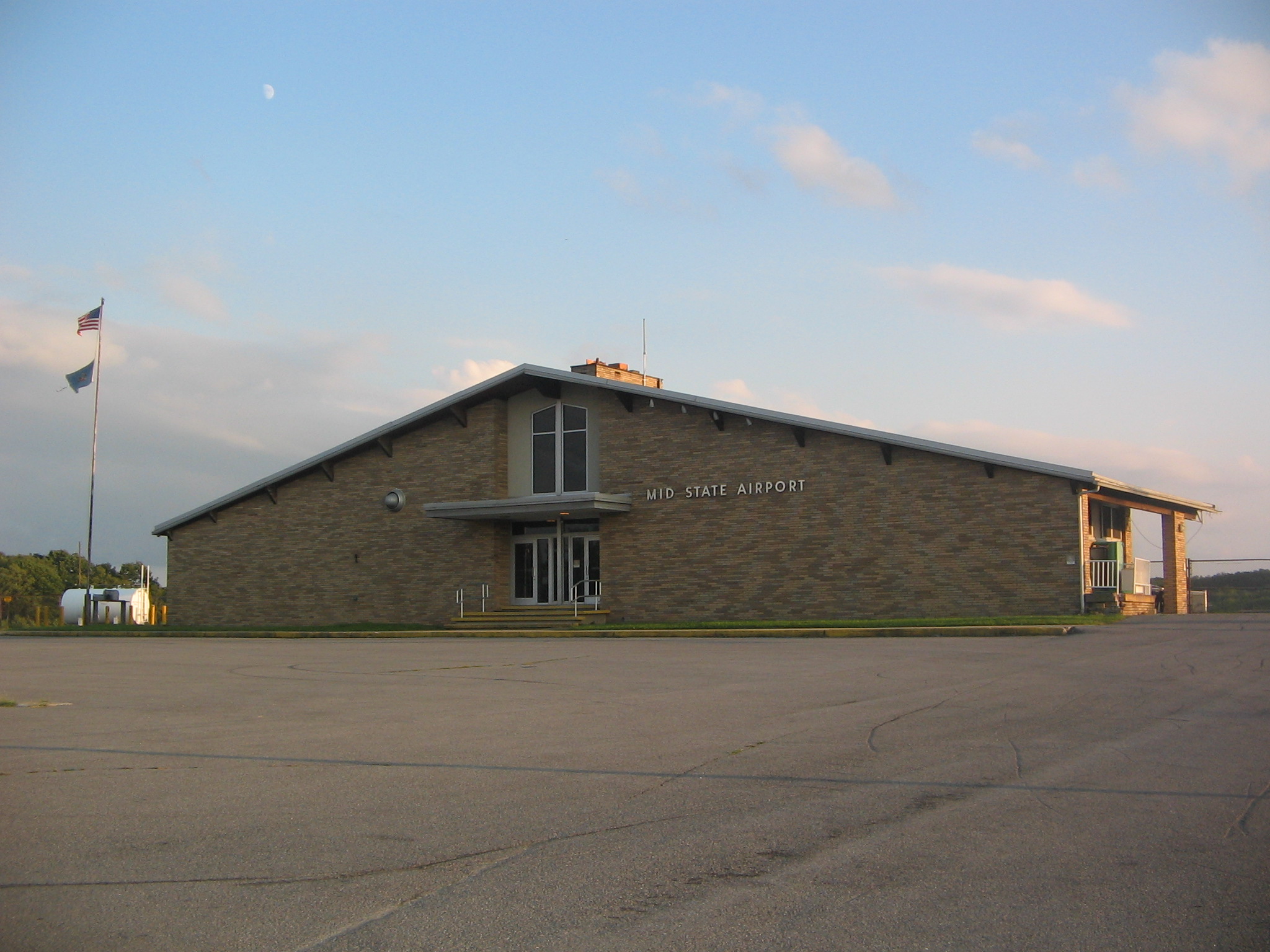
| Main building of Mid-State Regional Airport |
| IATA: PSB – ICAO: KPSB – FAA LID: PSB |
| Summary |
| Airport type |
Public |
| Owner |
Mid-State Regional Airport Authority |
| Serves |
Philipsburg, Pennsylvania |
| Location |
Rush Township, Centre County, Pennsylvania |
| Elevation AMSL |
1909 ft / 582 m |
| Coordinates |
40°53′00″N 78°05′14″W / 40.8833333°N 78.08722°W / 40.8833333; -78.08722 |
| Runways |
| Direction |
Length |
Surface |
| ft |
m |
| 16/34 |
5,711 |
1,741 |
Asphalt |
| 6/24 |
5,006 |
1,526 |
Asphalt |
| Statistics (2007) |
| Aircraft operations |
2,550 |
| Source: Federal Aviation Administration |
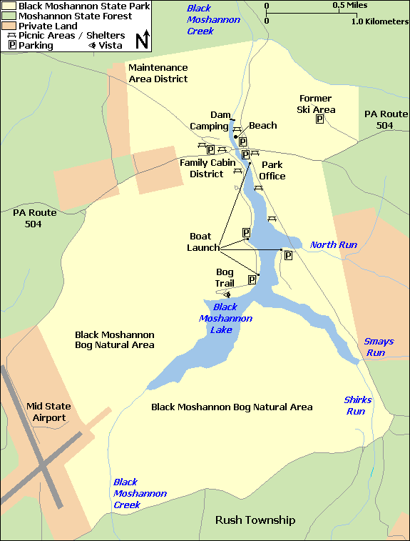
Mid-State Regional Airport (IATA: PSB, ICAO: KPSB, FAA LID: PSB), also known as Mid-State Airport, is a small airport in Rush Township, Centre County in Pennsylvania in the United States. It is located between Black Moshannon State Park to the east and Moshannon State Forest in all other directions.
The airport is 8 nautical miles (15 km) east of the central business district of Philipsburg. It is also 5 miles (8.0 km) from U.S. Route 322 and 10 miles (16 km) from Interstate 80. History
 | |
Location of Mid-State Regional Airport relative to Black Moshannon State Park |
"Black Moshannon Airport" was built on land taken from Black Moshannon State Park and Moshannon State Forest just prior to the Second World War, and was operational by 1942, hosting a Civil Air Patrol training exercise for nearly 300 planes on May 30, 1942. It was re-named "Mid-State Airport" in 1962.
The airport is 20 miles (32 km) from State College and Pennsylvania State University, and until the 1970s it was served by Allegheny Airlines (now US Airways). Over 75% of the airport's passengers were from the State College and Bellefonte area. After the new University Park Airport, owned by Penn State, opened in 1972, Allegheny Airlines gradually switched its service from Mid-State to University Park. Today there is no scheduled airline service to Mid-State Regional Airport.
As of 2008, the official name is "Mid-State Regional Airport" and it has been designated a Keystone Opportunity Zone (KOZ). The KOZ portion of the airport is on 484 acres (1.96 km) to encourage business growth and is designated a KOZ through December 31, 2010. However, there are limitations in state law that prohibit any further development on park or forest lands.
Facilities and aircraft
Mid-State Airport covers an area of 500 acres (2.0 km) which contains two asphalt paved runways: 16/34 measuring 5,711 x 100 ft (1,741 x 30 m) and 6/24 measuring 5,006 x 100 ft (1,526 x 30 m). For the 12-month period ending June 30, 2007, the airport had 2,550 aircraft operations: 98% general aviation and 2% military. Only two aircraft are based at the airport.
There are five taxiways at the airport, designated A, B, C, D, and E. Runway 16/34 is connected to the airport ramp (or apron) by the 69-foot (21 m) wide taxiway A, as well as the 50-foot (15 m) wide taxiways D and E. Both D and E connect to the east side of the runway, with D leading to the large hanger and E to the smaller T-hangar. Runway 6/24 is connected to the airport ramp by the 96-foot (29 m) wide taxiway B, and the 50-foot (15 m) wide taxiway C at the 24-end of the runway. All of the taxiways are asphalt except for E, which is turf for the last 240 feet (73 m) before the runway.
Other Users of the Airport
Based at Mid-State Regional Airport is the Civil Air Patrol Mid-State Composite Squadron 239. The Pennsylvania Bureau of Forestry bases a fire fighting aircraft at the airport during peak forest fire seasons.
The above content comes from Wikipedia and is published under free licenses – click here to read more.

Location & QuickFacts
| FAA Information Effective: | 2008-09-25 |
| Airport Identifier: | PSB |
| Airport Status: | Operational |
| Longitude/Latitude: | 078-05-14.4300W/40-53-03.8090N
-78.087342/40.884391 (Estimated) |
| Elevation: | 1948 ft / 593.75 m (Surveyed) |
| Land: | 500 acres |
| From nearest city: | 8 nautical miles E of Philipsburg, PA |
| Location: | Centre County, PA |
| Magnetic Variation: | 09W (1985) |
Owner & Manager
| Ownership: | Publicly owned |
| Owner: | Mid State Reg Arpt Auth |
| Address: | 451 Airport Road
Philipsburg, PA 16866 |
| Phone number: | 814-342-2280 |
| Manager: | Dave Liebegott |
| Address: | 451 Airport Road
Philipsburg, PA 16866 |
| Phone number: | 814-342-3263 |
Airport Operations and Facilities
| Airport Use: | Open to public |
| Wind indicator: | No |
| Segmented Circle: | Yes |
| Control Tower: | No |
| Lighting Schedule: | DUSK-DAWN
ACTVT MIRL RY 06/24 & 16/34; MALSR RY 16 & PAPI RY 24 - CTAF. |
| Beacon Color: | Clear-Green (lighted land airport) |
| Landing fee charge: | No |
| Sectional chart: | Detroit |
| Region: | AEA - Eastern |
| Boundary ARTCC: | ZNY - New York |
| Tie-in FSS: | AOO - Altoona |
| FSS on Airport: | No |
| FSS Toll Free: | 1-800-WX-BRIEF |
| NOTAMs Facility: | AOO (NOTAM-d service avaliable) |
| Federal Agreements: | NGY |
Airport Communications
Airport Services
| Fuel available: | 100LLA
FOR FUEL AFTER HRS CALL 814-342-1011. |
| Airframe Repair: | MINOR |
| Power Plant Repair: | NONE |
| Bottled Oxygen: | NONE |
| Bulk Oxygen: | NONE |
Runway Information
Runway 06/24
| Dimension: | 5006 x 100 ft / 1525.8 x 30.5 m |
| Surface: | ASPH, Fair Condition |
| Weight Limit: | Single wheel: 48000 lbs.
Dual wheel: 60000 lbs.
Dual tandem wheel: 90000 lbs. |
| Edge Lights: | Medium |
| |
Runway 06 |
Runway 24 |
| Longitude: | 078-05-39.4640W | 078-04-49.7700W |
| Latitude: | 40-52-40.2400N | 40-53-12.2310N |
| Elevation: | 1867.00 ft | 1917.00 ft |
| Alignment: | 50 | 127 |
| Traffic Pattern: | Left | Left |
| Markings: | Non-precision instrument, Poor Condition | Non-precision instrument, Poor Condition
RY 06/24 MKGS FADED. |
| Crossing Height: | 0.00 ft | 55.00 ft |
| VASI: | | 4-light PAPI on left side |
| Visual Glide Angle: | 0.00° | 3.00° |
| Obstruction: | 13 ft trees, 223.0 ft from runway, 129 ft right of centerline, 1:1 slope to clear | 37 ft trees, 442.0 ft from runway, 34 ft left of centerline, 6:1 slope to clear
RY 24 HAS BRUSH/TREES 152 FT WEST ACROSS APCH |
|
Runway 16/34
| Dimension: | 5711 x 100 ft / 1740.7 x 30.5 m |
| Surface: | ASPH, Good Condition |
| Weight Limit: | Single wheel: 48000 lbs.
Dual wheel: 60000 lbs.
Dual tandem wheel: 90000 lbs. |
| Edge Lights: | Medium |
| |
Runway 16 |
Runway 34 |
| Longitude: | 078-05-29.3650W | 078-04-59.2040W |
| Latitude: | 40-53-36.2040N | 40-52-44.6280N |
| Elevation: | 1948.00 ft | 1922.00 ft |
| Alignment: | 127 | 127 |
| ILS Type: | ILS
| |
| Traffic Pattern: | Left | Left |
| Markings: | Precision instrument, Poor Condition | Precision instrument, Poor Condition
RY 16/34 MKGS FADED. |
| Approach lights: | MALSR | |
| Obstruction: | 45 ft trees, 1502.0 ft from runway, 288 ft right of centerline, 28:1 slope to clear | 27 ft trees, 540.0 ft from runway, 428 ft right of centerline, 12:1 slope to clear
RY 34 HAS BRUSH 291 FT EAST ACROSS APCH |
|
Radio Navigation Aids
| ID |
Type |
Name |
Ch |
Freq |
Var |
Dist |
| RV | NDB | Stroh | | 407.00 | 10W | 23.4 nm |
| INP | NDB | Indiana | | 242.00 | 08W | 47.1 nm |
| AOO | VOR | Altoona | | 108.80 | 07W | 35.0 nm |
| REC | VOR/DME | Revloc | 043X | 110.60 | 09W | 36.3 nm |
| PSB | VORTAC | Philipsburg | 102X | 115.50 | 10W | 4.7 nm |
| TON | VORTAC | Tyrone | 096X | 114.90 | 07W | 14.3 nm |
| ETG | VORTAC | Keating | 107X | 116.00 | 10W | 20.0 nm |
| SLT | VORTAC | Slate Run | 086X | 113.90 | 08W | 38.1 nm |
| JST | VORTAC | Johnstown | 077X | 113.00 | 06W | 48.2 nm |
Remarks
- DEER ON & INVOF ARPT.
- HEAVY GLIDER ACTIVITY DURING DALGT HRS, ALL ALTS, WITHIN 15 NM EAST AND SOUTH OF ARPT.
- EXISTENCE PREDATES REQMT FOR ANALYSIS.
Images and information placed above are from
http://www.airport-data.com/airport/PSB/
We thank them for the data!
| General Info
|
| Country |
United States
|
| State |
PENNSYLVANIA
|
| FAA ID |
PSB
|
| Latitude |
40-53-03.809N
|
| Longitude |
078-05-14.430W
|
| Elevation |
1948 feet
|
| Near City |
PHILIPSBURG
|
We don't guarantee the information is fresh and accurate. The data may
be wrong or outdated.
For more up-to-date information please refer to other sources.
|
|