 |
|
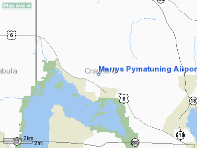
Merrys Pymatuning Airport |
Location & QuickFacts
| FAA Information Effective: | 2008-09-25 |
| Airport Identifier: | PA01 |
| Airport Status: | Operational |
| Longitude/Latitude: | 080-26-04.2430W/41-40-30.1960N
-80.434512/41.675054 (Estimated) |
| Elevation: | 1203 ft / 366.67 m (Estimated) |
| Land: | 147 acres |
| From nearest city: | 1 nautical miles NW of Linesville, PA |
| Location: | Crawford County, PA |
| Magnetic Variation: | 08W (1985) |
Owner & Manager
| Ownership: | Privately owned |
| Owner: | Pymatuningarea Recreatn'l Air |
| Address: | Rd 2, Airport Road
Linesville, PA 16424 |
| Phone number: | 814-382-8828 |
| Manager: | Dale Whitehead |
| Address: | Po Box 193
Conneaut Lake, PA 16316 |
| Phone number: | 814-382-8828 |
Airport Operations and Facilities
| Airport Use: | Private |
| Wind indicator: | Yes |
| Segmented Circle: | No |
| Control Tower: | No |
| Landing fee charge: | No |
| Sectional chart: | Detroit |
| Region: | AEA - Eastern |
| Boundary ARTCC: | ZOB - Cleveland |
| Tie-in FSS: | AOO - Altoona |
| FSS on Airport: | No |
| FSS Toll Free: | 1-800-WX-BRIEF |
Airport Services
| Airframe Repair: | NONE |
| Power Plant Repair: | NONE |
Runway Information
Runway 04/22
| Dimension: | 1815 x 120 ft / 553.2 x 36.6 m |
| Surface: | TURF, Good Condition |
| |
Runway 04 |
Runway 22 |
| Traffic Pattern: | Left | Left |
| Obstruction: | 83 ft trees, 415.0 ft from runway, 143 ft left of centerline, 5:1 slope to clear | 19 ft pole, 380.0 ft from runway, 60 ft left of centerline, 20:1 slope to clear |
|
Radio Navigation Aids
| ID |
Type |
Name |
Ch |
Freq |
Var |
Dist |
| CQD | NDB | Cascade | | 372.00 | 08W | 30.5 nm |
| HBD | NDB | Hubbard | | 408.00 | 08W | 31.7 nm |
| ORJ | NDB | Corry | | 258.00 | 09W | 38.0 nm |
| UCP | NDB | Castle | | 272.00 | 09W | 39.2 nm |
| LQL | NDB | Lakeland | | 263.00 | 08W | 42.4 nm |
| FKL | VOR | Franklin | | 109.60 | 06W | 29.6 nm |
| JFN | VOR/DME | Jefferson | 099X | 115.20 | 05W | 15.0 nm |
| CXR | VOR/DME | Chardon | 074X | 112.70 | 05W | 34.1 nm |
| LNN | VOR/DME | Lost Nation | 039X | 110.20 | 08W | 42.9 nm |
| ACO | VOR/DME | Akron | 091X | 114.40 | 04W | 48.6 nm |
| ERI | VORTAC | Erie | 031X | 109.40 | 06W | 21.5 nm |
| YNG | VORTAC | Youngstown | 027X | 109.00 | 05W | 23.3 nm |
| TDT | VORTAC | Tidioute | 123X | 117.60 | 09W | 45.7 nm |
Remarks
- ARPT GOOD TURF, SOFT DURING SPRING THAWS.
- WINTER USE AT OPTION OF BASED ACFT.
- PRIOR TO 1957
Images and information placed above are from
http://www.airport-data.com/airport/PA01/
We thank them for the data!
| General Info
|
| Country |
United States
|
| State |
PENNSYLVANIA
|
| FAA ID |
PA01
|
| Latitude |
41-40-30.196N
|
| Longitude |
080-26-04.243W
|
| Elevation |
1203 feet
|
| Near City |
LINESVILLE
|
We don't guarantee the information is fresh and accurate. The data may
be wrong or outdated.
For more up-to-date information please refer to other sources.
|
|


