 |
|
Location & QuickFacts
| FAA Information Effective: | 2008-09-25 |
| Airport Identifier: | 76PN |
| Airport Status: | Operational |
| Longitude/Latitude: | 080-19-09.2250W/40-42-40.2360N
-80.319229/40.711177 (Estimated) |
| Elevation: | 1132 ft / 345.03 m (Surveyed) |
| Land: | 0 acres |
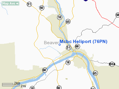
| From nearest city: | 1 nautical miles NW of Beaver, PA |
| Location: | Beaver County, PA |
| Magnetic Variation: | 07W (1985) |
Owner & Manager
| Ownership: | Privately owned |
| Owner: | The Med Ctr Of Beaver, Pa Inc |
| Address: | 1000 Dutch Ridge Road
Beaver, PA 15009 |
| Phone number: | 412-728-7000 |
| Manager: | Robert N. Gibson |
| Address: | 1000 Dutch Ridge Road
Beaver, PA 15009 |
| Phone number: | 412-728-7000 |
Airport Operations and Facilities
| Airport Use: | Private
MEDICAL USE. |
| Wind indicator: | Yes |
| Segmented Circle: | No |
| Control Tower: | No |
| Lighting Schedule: | PHONE REQ
PHONE 412-728-7000 FOR BEACON & HELIPAD LIGHTS. |
| Landing fee charge: | No |
| Sectional chart: | Detroit |
| Region: | AEA - Eastern |
| Boundary ARTCC: | ZOB - Cleveland |
| Tie-in FSS: | AOO - Altoona |
| FSS on Airport: | No |
| FSS Toll Free: | 1-800-WX-BRIEF |
Runway Information
Helipad H1
| Dimension: | 100 x 80 ft / 30.5 x 24.4 m |
| Surface: | CONC, |
| Edge Lights: | Low |
| |
Runway H1 |
Runway |
| Traffic Pattern: | Left | Left |
| Markings: | Basic, | , |
|
Radio Navigation Aids
| ID |
Type |
Name |
Ch |
Freq |
Var |
Dist |
| UCP | NDB | Castle | | 272.00 | 09W | 19.3 nm |
| HBD | NDB | Hubbard | | 408.00 | 08W | 28.2 nm |
| MKP | NDB | Mc Keesport | | 287.00 | 07W | 32.6 nm |
| PNU | NDB | Washington County | | 255.00 | 08W | 34.8 nm |
| TSO | NDB | Tolson | | 395.00 | 07W | 35.7 nm |
| CFX | NDB | Cadiz | | 239.00 | 07W | 42.7 nm |
| FKL | VOR | Franklin | | 109.60 | 06W | 48.5 nm |
| AGC | VOR/DME | Allegheny | 037X | 110.00 | 09W | 28.9 nm |
| HLG | VOR/DME | Wheeling | 059X | 112.20 | 07W | 29.4 nm |
| ACO | VOR/DME | Akron | 091X | 114.40 | 04W | 46.6 nm |
| CIP | VOR/DME | Clarion | 076X | 112.90 | 06W | 47.0 nm |
| AIR | VOR/DME | Bellaire | 118X | 117.10 | 07W | 47.6 nm |
| EWC | VORTAC | Ellwood City | 105X | 115.80 | 08W | 8.4 nm |
| MMJ | VORTAC | Montour | 057X | 112.00 | 08W | 14.6 nm |
| YNG | VORTAC | Youngstown | 027X | 109.00 | 05W | 40.6 nm |
Images and information placed above are from
http://www.airport-data.com/airport/76PN/
We thank them for the data!
| General Info
|
| Country |
United States
|
| State |
PENNSYLVANIA
|
| FAA ID |
76PN
|
| Latitude |
40-42-40.236N
|
| Longitude |
080-19-09.225W
|
| Elevation |
1132 feet
|
| Near City |
BEAVER
|
We don't guarantee the information is fresh and accurate. The data may
be wrong or outdated.
For more up-to-date information please refer to other sources.
|
|


