 |
|
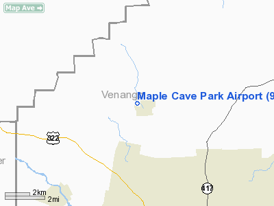
Location & QuickFacts
| FAA Information Effective: | 2008-09-25 |
| Airport Identifier: | 93PA |
| Airport Status: | Operational |
| Longitude/Latitude: | 079-52-53.2040W/41-30-12.2000N
-79.881446/41.503389 (Estimated) |
| Elevation: | 1180 ft / 359.66 m (Estimated) |
| Land: | 0 acres |
| From nearest city: | 1 nautical miles W of Cooperstown, PA |
| Location: | Venango County, PA |
| Magnetic Variation: | 08W (1985) |
Owner & Manager
| Ownership: | Privately owned |
| Owner: | P.e. Deeter |
| Address: | 117 Mill St Box 117
Cooperstown, PA 16317 |
| Phone number: | 814-374-4668 |
| Manager: | P.e. Deeter |
| Address: | 117 Mill St Box 117
Cooperstown, PA 16317 |
| Phone number: | 814-374-4668 |
Airport Operations and Facilities
| Airport Use: | Private |
| Wind indicator: | Yes |
| Segmented Circle: | No |
| Control Tower: | No |
| Landing fee charge: | No |
| Sectional chart: | Detroit |
| Region: | AEA - Eastern |
| Boundary ARTCC: | ZOB - Cleveland |
| Tie-in FSS: | AOO - Altoona |
| FSS on Airport: | No |
| FSS Toll Free: | 1-800-WX-BRIEF |
Runway Information
Runway N/S
| Dimension: | 2000 x 100 ft / 609.6 x 30.5 m |
| Surface: | TURF, |
| |
Runway N |
Runway S |
| Traffic Pattern: | Left | Left |
|
Radio Navigation Aids
| ID |
Type |
Name |
Ch |
Freq |
Var |
Dist |
| ORJ | NDB | Corry | | 258.00 | 09W | 26.7 nm |
| HBD | NDB | Hubbard | | 408.00 | 08W | 36.1 nm |
| UCP | NDB | Castle | | 272.00 | 09W | 37.6 nm |
| CQD | NDB | Cascade | | 372.00 | 08W | 38.3 nm |
| FKL | VOR | Franklin | | 109.60 | 06W | 4.0 nm |
| CIP | VOR/DME | Clarion | 076X | 112.90 | 06W | 28.7 nm |
| JFN | VOR/DME | Jefferson | 099X | 115.20 | 05W | 41.9 nm |
| TDT | VORTAC | Tidioute | 123X | 117.60 | 09W | 24.4 nm |
| ERI | VORTAC | Erie | 031X | 109.40 | 06W | 36.0 nm |
| YNG | VORTAC | Youngstown | 027X | 109.00 | 05W | 37.2 nm |
| EWC | VORTAC | Ellwood City | 105X | 115.80 | 08W | 43.4 nm |
Images and information placed above are from
http://www.airport-data.com/airport/93PA/
We thank them for the data!
| General Info
|
| Country |
United States
|
| State |
PENNSYLVANIA
|
| FAA ID |
93PA
|
| Latitude |
41-30-12.200N
|
| Longitude |
079-52-53.204W
|
| Elevation |
1180 feet
|
| Near City |
COOPERSTOWN
|
We don't guarantee the information is fresh and accurate. The data may
be wrong or outdated.
For more up-to-date information please refer to other sources.
|
|


