 |
|
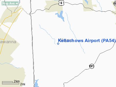
Location & QuickFacts
| FAA Information Effective: | 2008-09-25 |
| Airport Identifier: | PA54 |
| Airport Status: | Operational |
| Longitude/Latitude: | 075-23-45.6500W/41-31-20.3060N
-75.396014/41.522307 (Estimated) |
| Elevation: | 1430 ft / 435.86 m (Estimated) |
| Land: | 0 acres |
| From nearest city: | 6 nautical miles SE of Carbondale, PA |
| Location: | Wayne County, PA |
| Magnetic Variation: | 12W (1985) |
Owner & Manager
| Ownership: | Privately owned |
| Owner: | Vladimer Kellachow |
| Address: | Rd2 Box 190
Waymart, PA 18472 |
| Phone number: | 717-937-4317 |
| Manager: | Vladimer Kellachow |
| Address: | Rd 2, Box 190
Waymart, PA 18472 |
| Phone number: | 717-937-4317 |
Airport Operations and Facilities
| Airport Use: | Private |
| Wind indicator: | Yes |
| Segmented Circle: | No |
| Control Tower: | No |
| Sectional chart: | New York |
| Region: | AEA - Eastern |
| Boundary ARTCC: | ZNY - New York |
| Tie-in FSS: | IPT - Williamsport |
| FSS Toll Free: | 1-800-WX-BRIEF |
Runway Information
Runway 01/19
| Dimension: | 2555 x 100 ft / 778.8 x 30.5 m |
| Surface: | TURF, |
| |
Runway 01 |
Runway 19 |
| Traffic Pattern: | Left | Left |
| Displaced threshold: | 680.00 ft | 460.00 ft |
| Obstruction: | 20 ft pline, 125.0 ft from runway | , 400.0 ft from runway |
|
Radio Navigation Aids
| ID |
Type |
Name |
Ch |
Freq |
Var |
Dist |
| CYE | NDB | Crystal Lake | | 410.00 | 11W | 27.2 nm |
| MS | NDB | Monga | | 359.00 | 12W | 28.2 nm |
| HXM | NDB | Humbolt | | 366.00 | 10W | 42.0 nm |
| LQX | NDB | Carbon | | 339.00 | 12W | 45.7 nm |
| HZL | VOR | Hazleton | | 109.40 | 09W | 46.6 nm |
| HNK | VOR/DME | Hancock | 115X | 116.80 | 11W | 32.7 nm |
| HUO | VOR/DME | Huguenot | 108X | 116.10 | 11W | 36.9 nm |
| STW | VOR/DME | Stillwater | 033X | 109.60 | 11W | 39.6 nm |
| DNY | VOR/DME | De Lancey | 058X | 112.10 | 11W | 44.1 nm |
| LHY | VORTAC | Lake Henry | 045X | 110.80 | 10W | 4.8 nm |
| LVZ | VORTAC | Wilkes-barre | 053X | 111.60 | 10W | 20.0 nm |
| SAX | VORTAC | Sparta | 104X | 115.70 | 11W | 47.4 nm |
| FJC | VORTAC | Allentown | 122X | 117.50 | 10W | 47.9 nm |
Remarks
- PRVDD RY 01 THR DSPLCD 275' TO ENSURE A 20:1 OBST CLNC SLOPE OVER 20' PLINE 125' S OF RY. ENSURE DSPLCD THR IS PROPERLY MARKED.
Images and information placed above are from
http://www.airport-data.com/airport/PA54/
We thank them for the data!
| General Info
|
| Country |
United States
|
| State |
PENNSYLVANIA
|
| FAA ID |
PA54
|
| Latitude |
41-31-20.306N
|
| Longitude |
075-23-45.650W
|
| Elevation |
1430 feet
|
| Near City |
CARBONDALE
|
We don't guarantee the information is fresh and accurate. The data may
be wrong or outdated.
For more up-to-date information please refer to other sources.
|
|


