 |
|
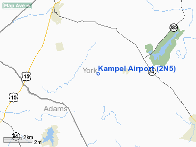
Location & QuickFacts
| FAA Information Effective: | 2008-09-25 |
| Airport Identifier: | 2N5 |
| Airport Status: | Operational |
| Longitude/Latitude: | 076-58-40.9160W/40-02-54.3390N
-76.978032/40.048428 (Estimated) |
| Elevation: | 610 ft / 185.93 m (Estimated) |
| Land: | 14 acres |
| From nearest city: | 2 nautical miles W of Wellsville, PA |
| Location: | York County, PA |
| Magnetic Variation: | 10W (1985) |
Owner & Manager
| Ownership: | Privately owned |
| Owner: | Kampel Ent. Inc. |
| Address: | 8930 Carlisle Rd
Wellsville, PA 17365 |
| Phone number: | 717-432-9688 |
| Manager: | Thomas E Kampel |
| Address: | 8930 Carlisle Rd
Wellsville, PA 17365 |
| Phone number: | 717-432-9688 |
Airport Operations and Facilities
| Airport Use: | Open to public |
| Wind indicator: | Yes |
| Segmented Circle: | No |
| Control Tower: | No |
| Landing fee charge: | No |
| Sectional chart: | New York |
| Region: | AEA - Eastern |
| Boundary ARTCC: | ZNY - New York |
| Tie-in FSS: | IPT - Williamsport |
| FSS on Airport: | No |
| FSS Toll Free: | 1-800-WX-BRIEF
FILE IFR & PICKUP CLEARANCE...TOLL FREE NR 800-932-0712. |
| NOTAMs Facility: | IPT (NOTAM-d service avaliable) |
Airport Communications
Airport Services
| Fuel available: | 100LL |
| Airframe Repair: | MINOR |
| Power Plant Repair: | NONE |
| Bottled Oxygen: | NONE |
| Bulk Oxygen: | NONE |
Runway Information
Runway 05/23
| Dimension: | 2500 x 100 ft / 762.0 x 30.5 m |
| Surface: | TURF, Good Condition |
| |
Runway 05 |
Runway 23 |
| Traffic Pattern: | Left | Left |
| Displaced threshold: | 0.00 ft | 300.00 ft
DSPLCD THR MKD WITH 2 YELLOW CONES EACH SIDE OF RY. |
| Obstruction: | 48 ft tank, 1123.0 ft from runway, 178 ft right of centerline, 23:1 slope to clear | 64 ft trees, 899.0 ft from runway, 42 ft right of centerline, 14:1 slope to clear
RY 23 APCH SLOPE 18:1 TO DSPLCD THLD. |
|
Radio Navigation Aids
| ID |
Type |
Name |
Ch |
Freq |
Var |
Dist |
| EUD | NDB | York | | 254.00 | 11W | 9.0 nm |
| BZJ | NDB | Bellgrove | | 328.00 | 10W | 30.4 nm |
| FND | NDB | Ellicott | | 371.00 | 11W | 46.7 nm |
| RV | NDB | Stroh | | 407.00 | 10W | 48.0 nm |
| IUB | NDB | Institute | | 404.00 | 08W | 48.6 nm |
| FDK | VOR | Frederick | | 109.00 | 08W | 42.4 nm |
| HGR | VOR | Hagerstown | | 109.80 | 07W | 45.6 nm |
| HAR | VORTAC | Harrisburg | 072X | 112.50 | 10W | 15.8 nm |
| LRP | VORTAC | Lancaster | 120X | 117.30 | 09W | 31.9 nm |
| EMI | VORTAC | Westminster | 126X | 117.90 | 08W | 33.3 nm |
| RAV | VORTAC | Ravine | 093X | 114.60 | 11W | 35.0 nm |
| SEG | VORTAC | Selinsgrove | 041X | 110.40 | 08W | 44.8 nm |
| THS | VORTAC | St Thomas | 097X | 115.00 | 07W | 45.3 nm |
| MDT | VOT | Harrisburg International | | 110.00 | | 13.3 nm |
Remarks
- ARPT CLSD TO TRANSIENT ACFT DEC-MAR.
- VFR USE ONLY.
Images and information placed above are from
http://www.airport-data.com/airport/2N5/
We thank them for the data!
| General Info
|
| Country |
United States
|
| State |
PENNSYLVANIA
|
| FAA ID |
2N5
|
| Latitude |
40-02-54.339N
|
| Longitude |
076-58-40.916W
|
| Elevation |
610 feet
|
| Near City |
WELLSVILLE
|
We don't guarantee the information is fresh and accurate. The data may
be wrong or outdated.
For more up-to-date information please refer to other sources.
|
|


