 |
|
John Murtha Johnstown-cambria Co Airport |
| John Murtha Johnstown-Cambria County Airport |
 |
| IATA: JST – ICAO: KJST – FAA LID: JST |
| Summary |
| Airport type |
Public |
| Owner |
Johnstown-Cambria County Airport Authority |
| Operator |
www.flyjohnstownairport.com |
| Serves |
Johnstown, Pennsylvania |
| Elevation AMSL |
2,284 ft / 696 m |
| Coordinates |
40°18′58″N 078°50′02″W / 40.31611°N 78.83389°W / 40.31611; -78.83389 |
| Runways |
| Direction |
Length |
Surface |
| ft |
m |
| 15/33 |
7,003 |
2,135 |
Concrete |
| 5/23 |
4,386 |
1,337 |
Asphalt |
| Statistics (2007) |
| Aircraft operations |
59,430 |
| Based aircraft |
69 |
| Source: Federal Aviation Administration |
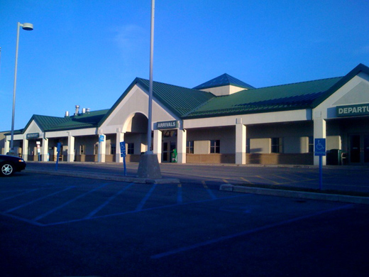
The John Murtha Johnstown-Cambria County Airport in Johnstown, Pennsylvania is mostly used for general aviation, but is also served by one commercial airline. Service is subsidized by the Essential Air Service.
The John Murtha Johnstown-Cambria County (JMJCC) Airport is home to several military units. The airport houses the Pennsylvania Army National Guard 1-104th Attack Reconnaissance Battalion (Company's HHC,A,C,D, and E) and Det 1, 1-169th Aviation (Med-Evac). It also houses the 258th Air Traffic Control Squadron of the Pennsylvania Air National Guard, the Marine Wing Support Squadron 471 (MWSS-471), Detachment A, and the Marine Light Attack Helicopter Squadron 775 (HMLA-775), Detachment A. These military units use helicopters, rather than fixed-wing planes. Facilities and aircraft
John Murtha Johnstown-Cambria County Airport covers an area of 650 acres (263 ha) at an elevation of 2,284 feet (696 m) above mean sea level. It has one asphalt paved, R/W 23/5 and one concrete runway R/W 33/15]s: 15/33 measuring 7,003 x 150 feet (2,135 x 46 m) and 5/23 measuring 4,386 x 100 feet (1,337 x 30 m).
For the 12-month period ending December 31, 2007, the airport had 59,430 aircraft operations, an average of 162 per day: 64% general aviation, 29% military, 6% air taxi and 2% scheduled commercial. At that time there were 69 aircraft based at this airport: 38% single-engine, 6% multi-engine, 1% jet and 55% military.
Airlines and destinations
| Airlines |
Destinations |
| United Express operated by Colgan Air |
Washington-Dulles, Altoona-Blair County |
History
The airport was dedicated in 1948, and at one time was served by both Allegheny Airlines and Mohawk. When US Airways ended service to Altoona, Pennsylvania and Pittsburgh, United Express picked it up with service to Altoona and Washington-Dulles.
Finances
Although the airport only offers three commercial flights and has very little other activity, as of April 2009, the airport had received almost $200 million in federal subsidies. That funding has not been used to subsidize the facility’s commercial, corporate and general aviation operations, including the terminal. Those funds have been used to construct a concrete reinforced runway for military purposes and to build military installations located near and around the airport proper. The airport is in the bottom 28% of all facilities receiving EAS funding. In 2004, an $8 million air traffic radar system was installed at the airport, but as of April 2009, it has never been used.
The above content comes from Wikipedia and is published under free licenses – click here to read more.
Location & QuickFacts
| FAA Information Effective: | 2008-09-25 |
| Airport Identifier: | JST |
| Airport Status: | Operational |
| Longitude/Latitude: | 078-50-02.2000W/40-18-58.0000N
-78.833944/40.316111 (Estimated) |
| Elevation: | 2284 ft / 696.16 m (Surveyed) |
| Land: | 650 acres |
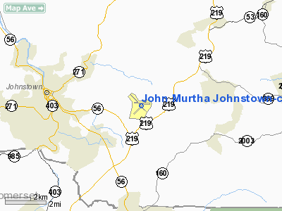
| From nearest city: | 3 nautical miles NE of Johnstown, PA |
| Location: | Cambria County, PA |
| Magnetic Variation: | 07W (1980) |
Owner & Manager
| Ownership: | Publicly owned |
| Owner: | Johnstown-cambria Co Apt Auth |
| Address: | 479 Arpt Road
Johnstown, PA 15904 |
| Phone number: | 814-536-0002 |
| Manager: | Terry Summerson |
| Address: | 479 Arpt Road
Johnstown, PA 15904 |
| Phone number: | 814-536-0002 |
Airport Operations and Facilities
| Airport Use: | Open to public |
| Wind indicator: | Yes |
| Segmented Circle: | No |
| Control Tower: | Yes |
| Lighting Schedule: | DUSK-DAWN
WHEN TWR CLSD ACTVT HIRL RY 15/33, MALSR RY 33, PAPI RY 33, TWY LGTS TWYS A, B, & G, & MAIN TERMINAL APRON - CTAF. MIRL RWY 5/23 UNAVAILABLE WHEN TOWER CLOSED. |
| Beacon Color: | Clear-Green (lighted land airport) |
| Landing fee charge: | Yes |
| Sectional chart: | Detroit |
| Region: | AEA - Eastern |
| Boundary ARTCC: | ZOB - Cleveland |
| Tie-in FSS: | AOO - Altoona |
| FSS Toll Free: | 1-800-WX-BRIEF |
| NOTAMs Facility: | JST (NOTAM-d service avaliable) |
| Certification type/date: | I A S 03/1974
48 HRS PPR FOR UNSCHEDULED ACR OPNS WITH MORE THAN 30 PSGR SEATS; CALL AMGR (814) 536-0002. |
| Federal Agreements: | NGYH3 |
Airport Communications
| CTAF: | 125.750 |
| Unicom: | 122.950
UNICOM FREQ 122.950 AVBL FOR GND SVCS ONLY. |
Airport Services
| Fuel available: | 100LLA |
| Airframe Repair: | MAJOR |
| Power Plant Repair: | MAJOR |
Runway Information
Runway 05/23
| Dimension: | 4386 x 100 ft / 1336.9 x 30.5 m |
| Surface: | ASPH, Good Condition |
| Surface Treatment: | Saw-cut or plastic Grooved |
| Weight Limit: | Single wheel: 62000 lbs.
Dual wheel: 87000 lbs. |
| Edge Lights: | Medium |
| |
Runway 05 |
Runway 23 |
| Longitude: | 078-50-21.6366W | 078-49-45.7320W |
| Latitude: | 40-18-37.4274N | 40-19-10.9490N |
| Elevation: | 2270.00 ft | 2280.00 ft |
| Alignment: | 39 | 127 |
| Traffic Pattern: | Left | Left |
| Markings: | Non-precision instrument, Good Condition | Non-precision instrument, Good Condition |
| Crossing Height: | 41.00 ft | 49.00 ft |
| VASI: | 4-light PAPI on left side | 4-box on left side |
| Visual Glide Angle: | 3.00° | 3.00° |
| Runway End Identifier: | | Yes |
| Obstruction: | , 50:1 slope to clear | 12 ft pole, 642.0 ft from runway, 165 ft right of centerline, 36:1 slope to clear |
|
Runway 15/33
| Dimension: | 7003 x 150 ft / 2134.5 x 45.7 m |
| Surface: | ASPH, Good Condition |
| Surface Treatment: | Saw-cut or plastic Grooved |
| Weight Limit: | Single wheel: 62000 lbs.
Dual wheel: 87000 lbs. |
| Edge Lights: | High |
| |
Runway 15 |
Runway 33 |
| Longitude: | 078-50-31.9405W | 078-49-38.9876W |
| Latitude: | 40-19-25.1720N | 40-18-29.0934N |
| Elevation: | 2270.00 ft | 2260.00 ft |
| Alignment: | 127 | 127 |
| ILS Type: | | ILS
|
| Traffic Pattern: | Left | Left |
| Markings: | Precision instrument, Good Condition | Precision instrument, Good Condition |
| Crossing Height: | 52.00 ft | 53.00 ft |
| VASI: | 4-box on left side | 4-light PAPI on right side |
| Visual Glide Angle: | 3.00° | 3.00° |
| Approach lights: | | MALSR |
| Obstruction: | 16 ft trees, 380.0 ft from runway, 485 ft left of centerline, 11:1 slope to clear | 22 ft ant, 1050.0 ft from runway, 620 ft left of centerline, 38:1 slope to clear |
|
Radio Navigation Aids
| ID |
Type |
Name |
Ch |
Freq |
Var |
Dist |
| SYS | NDB | Stoystown | | 209.00 | 08W | 14.4 nm |
| BHU | NDB | Benje | | 382.00 | 07W | 20.4 nm |
| INP | NDB | Indiana | | 242.00 | 08W | 21.7 nm |
| CBE | NDB | Cumberland | | 317.00 | 07W | 40.3 nm |
| MKP | NDB | Mc Keesport | | 287.00 | 07W | 43.5 nm |
| VV | NDB | Camor | | 299.00 | 08W | 49.3 nm |
| AOO | VOR | Altoona | | 108.80 | 07W | 24.3 nm |
| REC | VOR/DME | Revloc | 043X | 110.60 | 09W | 14.4 nm |
| GRV | VOR/DME | Grantsville | 070X | 112.30 | 06W | 42.1 nm |
| IHD | VORTAC | Indian Head | 019X | 108.20 | 06W | 31.7 nm |
| TON | VORTAC | Tyrone | 096X | 114.90 | 07W | 34.1 nm |
| THS | VORTAC | St Thomas | 097X | 115.00 | 07W | 46.7 nm |
Remarks
- ARNG: ALL TFC TO ARNG RAMP 1300-2130Z++WKDAY CTC KEYSTONE OPS, OT PPR C814-532-7714. RAMP PILOT CTL LGT 143.3.
- AR: ALL F/W RAMP USE PPR CTC AR 1300-2130Z++WKD C814-532-7600. F/W PRK FIRST 5 PADS FACING HGR. LTD MAINT F/W. RAMP PILOT CTL LGT TWY AND PRK, 143.3.
- BEARING STRENGTH RWYS 05-23 AND 15-33: ST110
- DEER & BIRDS ON & IN VICINITY AIRPORT.
- MILITARY USE: FSS-ALTOONA AOO-NOTAM JST
Images and information placed above are from
http://www.airport-data.com/airport/JST/
We thank them for the data!
| General Info
|
| Country |
United States
|
| State |
PENNSYLVANIA
|
| FAA ID |
JST
|
| Latitude |
40-18-58.000N
|
| Longitude |
078-50-02.200W
|
| Elevation |
2284 feet
|
| Near City |
JOHNSTOWN
|
We don't guarantee the information is fresh and accurate. The data may
be wrong or outdated.
For more up-to-date information please refer to other sources.
|
|


